Sold2020Johann Matthias Hase Homann Heirs World MapJohann Mathias Hase (1684-1742), "Planiglobii Terrestris Mappa Universalis: Utrumque Hemisphaerium Orient. et Occidentale Repraesentans," Nuremberg: Homann Heirs, 1746. Hand colored map of the world iSee Sold Price
Sold2022G.M. Lowitz Hand Colored Map EngravingG.M. Lowitz Hand Colored Map Engraving, Planiglobii Terrestris Mappa Universalis; Mappemonde Qui Représente Les Deux Hemisspheres Homann Heirs 1746, double page, crease marks, staining, soiling, foSee Sold Price
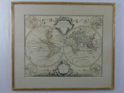
Sold2020Homann World Map*** START PRICE IS THE RESERVE *** [World] HOMANN, Heirs (18th century). Planiglobii Terrestris Mappa Universalis utrumque. Engraved map with original hand color in part. Nuremberg: Homann Heirs, 1746See Sold Price
Sold2022World Map Mappe-Monde ou Carte Generale du GlobeTitle: World Map Mappe-Monde ou Carte Generale du Globe Terrestre Date Printed: 1678 Cartographer: Sanson, Nicholas Material/Medium: atlas map, engraved, hand colored Size: 17 x 23 Condition: The mapSee Sold Price
Sold2022[ANTIQUE MAPS] DE VAUGONDY - MAPPE MONDE 1804[ANTIQUE MAPS] dE VAUGONDY, ROBERT. "MAPPE MONDE dressée suivant les nouvelles relations et assujettie aux observations astronomiques" 1804, 72X44cm. Hand-coloured. Frame not included. Map will beSee Sold Price
Sold2023[MAP] VALCK. MAPPE-MONDE GEO-HYDROGRAPHIQUE (1686)Valck, Gerard. MAPPE-MONDE GEO-HYDROGRAPHIQUE, OU DESCRIPTION GENERAL DU GLOBE TERRESTRE ET AQUATIQUE EN DEUX-PLANS-HEMISPHERES... Amsterdam, (circa 1686). Beautiful map, fully handcoloured, richly deSee Sold Price
Sold2016Large Framed World Map w/ Latin InscriptionsLarge Framed World Map w/ Latin Inscriptions. Hand colored. Professionally framed and matted. Titled Mappe Monde. Measures 28 by 33 inches.See Sold Price
Sold20171746 Homann World MapTitle: 1746 Homann World Map -- Planiglobii Terrestris Mappa Universalis utrumque Hemisphaerium Orient et Occidentale Repraesentans ex IV. Mappis Generalibus ... / Mappe-Monde qui Represente les DeuxSee Sold Price
Sold2019HOMANN HEIRS. Neue Welt Karte. Nuremberg, 1784. HOMANN HEIRS. Neue Welt Karte. Nuremberg, 1784. Engraved double hemisphere world map with hand-coloring in wash and outline, sheet 20 3/8 x 25 3/8 in. (518 x 647 mm), plate 18 1/2 x 21 7/8 in. (46See Sold Price
Sold2019Delamarche, Felix 1829 Map of World Hemispheres"Mappe-Monde ou Carte Generale du Globe Terrestre" Copper Engraved Map Published 1829, Paris for "Atlas de La Geographie..." by Felix Delamarche. Contemporary outline hand colour. Centre fold as publiSee Sold Price
Sold2015A. M. Perrot. Map of the World. 1837.Print of hand colored steel engraving titled Mappe - Monde“.Author A. M. Perrot.Engraved by unknown.From Dictionnaire universel Geographie moderne, description physique, politique et historique de tSee Sold Price
Sold2015Victor Lavasseur. Map of the world. 1830.Print of hand colored steel engraving titled Mappemonde“.Author Victor Lavasseur.Engraved by unknown.From Atlas classique universel de Geographie anciene et moderne“ by Victor Levasseur. Paris. 18See Sold Price
Sold2016Map of the World. 1854.Print of hand colored steel engraving titled „Mappemonde Physique et Politique”.Drawn by L. Dussieux. Engraved by unknown.From „Atlas General De Geographie physique, politique et historique parSee Sold Price
Sold2017Homann Heirs: Antique Map of North & South America 1746Title/Content of Map: Americae mappa generalis Date Printed: 1746 Cartographer: Homann Heirs Material/Medium: Paper Size: 23 1/2" x 21" Hand colored copperplate engraved. Published in Nuremberg. Map hSee Sold Price
Sold2017Homann Heirs: Antique Map of Europe, 1746Map: Europe ** Nuremberg?? Date Printed: 1746 Cartographer: Homann Heirs Material/Medium: Paper Size: 21" x 23 1/4" Nuremberg. Hand colored copperplate engraved. Beautiful baroque style cartouche. PleSee Sold Price
Sold2017Homann Heirs: Antique Map of Asia, 1746Map: Asia Date Printed: 1746 Cartographer: Homann Heirs Material/Medium: Paper Size: 23 3/4" x 21" Printed in Nuremberg. Hand colored copperplate engraved. Beautiful baroque style cartouche. Please noSee Sold Price
Sold2017Homman Heirs: Antique Map of Africa, 1746Map: Africa Date Printed: 1746 Cartographer: Homann Heirs Material/Medium: Paper Size: 23 1/4" x 21" Printed in Nuremberg. Thick paper. Hand colored copperplate engraved. Beautiful baroque style cartoSee Sold Price
Sold20181745 Covens and Mortier World Map -- Mappe-MondeTitle/Content of Map: 1745 Covens and Mortier World Map -- Mappe-Monde Dressee sur les Observations de Mrs. de l'Academie Royale des Sciences et Quelques Autres et sur les Memoires les Plus Recens DatSee Sold Price
20181745 Covens and Mortier World Map -- Mappe-MondeTitle/Content of Map: 1745 Covens and Mortier World Map -- Mappe-Monde Dressee sur les Observations de Mrs. de l'Academie Royale des Sciences et Quelques Autres et sur les Memoires les Plus Recens DatSee Sold Price
Sold20231651 Sanson World Map -- Mappe-Monde, ou Carte Generale du Monde; Dessignee en DeuxTitle: 1651 Sanson World Map -- Mappe-Monde, ou Carte Generale du Monde; Dessignee en Deux Plan-Hemispheres… Cartographer: N Sanson Year / Place: 1651, Paris Map Dimension (in.): 13.8 X 20.6 in.See Sold Price
Sold2019Antique Hand Colored Map Titled MappeAntique Hand Colored Map Mappe-Monde Indiquant les Possessions Coloniales des diverses Puissances By Drioux, Claude Joseph (1820 - 1898) [M. Drioux et Ch. Leroy] | Published Paris, Belin, 1859 | 19thSee Sold Price
Sold2017A Blondeau: Mappe-Monde ou Carte Generale de la TerreMap: Mappe-Monde ou Carte Generale de la Terre, 1817 Maker: A Blondeau Date: 1817, Paris Description: An uncommon two hemisphere world map. The shown US border far exceeds into Canada north of MinnesoSee Sold Price
Sold2021Rare Jaeger LeCoultre Mappemonde Illuminated Deco DeskBrand: Jaeger Le Coultre Model: World Map Illuminated Table Clock Approximate Dimensions: 250mm height x 200mm diameter Base: Octagonal Marble Base MovemeSee Sold Price
Sold2015AFTER GERARD VALCK MAP 1827AFTER GERARD VALCK (1651-1726), MAP, 1827, 17'' X 21'', MAPPE MONDE GEO HYDROGRAPHIQUE DU GLOBE, NOT FRAMED:Engraved, hand colored map showing the southern polar region, northern polar regions, and twSee Sold Price
May 22Hannam's Auctioneers LtdThe Complete Atlas of Modern, Classical and Celestial Maps, together with Plans of the Principal Cit£240
Jun 07Freeman's | Hindman[MAPS]. HOMANN, Johann Baptist, HOMANN HEIRS, and Georg Matthäus SEUTTER. [Composite Atlas].US$15,000
May 30Forum AuctionsMeunier (Charles, binder).- Haraucourt (Edmond) L'Effort: La Madone. L'Antéchrist. L'Immortalité.£2,600
May 29Carlo Bonte AuctionsJohn Lizars (ca. 1792-1860), a System of Anatomical Plates of the Human Body. Edinburgh: W.H. Lizars€425(2 bids)
May 26Ararity AuctionsThomson's 1817 Hand Colored Map Comparative Heights of the World's Great MountainsUS$50
9 hrs LeftWorld Auction Gallery LLCFramed Reproduction of an Antique Map of Iceland by Georgio CaroloUS$30
Jun 07Freeman's | Hindman[MAP]. ORTELIUS, Abraham. Americae Sive Novi Orbis, Nova Descriptio. 1573.US$1,000(1 bid)


![Homann World Map: *** START PRICE IS THE RESERVE *** [World] HOMANN, Heirs (18th century). Planiglobii Terrestris Mappa Universalis utrumque. Engraved map with original hand color in part. Nuremberg: Homann Heirs, 1746](https://p1.liveauctioneers.com/1968/163248/82424684_1_x.jpg?height=310&quality=70&version=1583340284)

![[ANTIQUE MAPS] DE VAUGONDY - MAPPE MONDE 1804: [ANTIQUE MAPS] dE VAUGONDY, ROBERT. "MAPPE MONDE dressée suivant les nouvelles relations et assujettie aux observations astronomiques" 1804, 72X44cm. Hand-coloured. Frame not included. Map will be](https://p1.liveauctioneers.com/8321/253807/131946557_1_x.jpg?height=310&quality=70&version=1657219401)
![[MAP] VALCK. MAPPE-MONDE GEO-HYDROGRAPHIQUE (1686): Valck, Gerard. MAPPE-MONDE GEO-HYDROGRAPHIQUE, OU DESCRIPTION GENERAL DU GLOBE TERRESTRE ET AQUATIQUE EN DEUX-PLANS-HEMISPHERES... Amsterdam, (circa 1686). Beautiful map, fully handcoloured, richly de](https://p1.liveauctioneers.com/8124/310027/165853628_1_x.jpg?height=310&quality=70&version=1700184289)


![Antique Hand Colored Map Titled Mappe: Antique Hand Colored Map Mappe-Monde Indiquant les Possessions Coloniales des diverses Puissances By Drioux, Claude Joseph (1820 - 1898) [M. Drioux et Ch. Leroy] | Published Paris, Belin, 1859 | 19th](https://p1.liveauctioneers.com/6084/152756/77258508_1_x.jpg?height=310&quality=70&version=1573249011)


![[MAP]. SPEED, John. A New Mappe of the Romane Empire. 1676. (1 of 2)](https://p1.liveauctioneers.com/197/329395/177650541_1_x.jpg?height=282&quality=70&version=1715364962)

![[MAPS]. HOMANN, Johann Baptist, HOMANN HEIRS, and Georg Matthäus SEUTTER. [Composite Atlas]. (1 of 5)](https://p1.liveauctioneers.com/197/329395/177650530_1_x.jpg?height=282&quality=70&version=1715364962)


![[MAP]. ORTELIUS, Abraham. Americae Sive Novi Orbis, Nova Descriptio. 1573. (1 of 2)](https://p1.liveauctioneers.com/197/329395/177650534_1_x.jpg?height=282&quality=70&version=1715364962)
![[MAP]. ORTELIUS, Abraham. Aevi Veteris, Typus Geographicus. 1601. (1 of 3)](https://p1.liveauctioneers.com/197/329395/177650532_1_x.jpg?height=282&quality=70&version=1715364962)
![[MAPS]. A group of 3 engraved maps, most with hand-coloring. (1 of 4)](https://p1.liveauctioneers.com/197/328642/177014805_1_x.jpg?height=282&quality=70&version=1714760103)

