Sold20231899 State of New York Framed Railroad Map - Colton Ohman & Co. PrinterLarge framed 1899 railroad map of the state of New York. This map was created by James B. Lyon to accompany the seventeenth annual report of the Board of Commissioners of the State of New York. The maSee Sold Price
Sold2023Delaware and Hudson RR Framed Bridge Line Route Map 1823-1973This large framed poster/map is from the Delaware and Hudson Railroad and shows their routes for both canal and railroad from 1823 to 1973, between New England and Canada. An excellent, full color pieSee Sold Price
Sold2016* Maine Railroad Map Framed 1914A large Railroad map of Maine dated to 1914. This map has been professionally framed. The frame measures 27" by 35". It's heavy. The map has a key showing the different railroad lines and each countySee Sold Price
Sold2020Large Framed Map of London, 1861Depicts London from the South Side of the Thames, this was a fold-out supplement to the illustrated London News, February 9, 1861, Rob Loudon Sr. Folds, creases, water stains in areas. Overall size: 2See Sold Price
Sold2022Large Framed Map of the City of Worcesterhas some creasing but presents nicely in the frame - Frame 71" x 61" Please see photos and come to the 2 day preview for condition.See Sold Price
Sold2023ESTATE OF SEYMOUR STEIN: 3 LARGE FRAMED MAPS/PRINTS - NY, PEEKSILL, PHILADELPIA EXHIBITION, LARGESTESTATE OF SEYMOUR STEIN: 3 LARGE FRAMED MAPS/PRINTS - NY, PEEKSILL, PHILADELPIA EXHIBITION, LARGEST IS 40" X 41"See Sold Price
Sold2018Large Framed 1794 Map of America Laurie & Whittle1794, London New Map of America & The West India Islands. With detailed side maps of California, and Baffin & Hudson Bay. Published by Laurie and Whittle. Map measures approximately 43.5" L x 49.5" H,See Sold Price
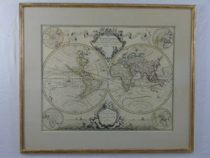
Sold2016Large Framed World Map w/ Latin InscriptionsLarge Framed World Map w/ Latin Inscriptions. Hand colored. Professionally framed and matted. Titled Mappe Monde. Measures 28 by 33 inches.See Sold Price
Sold2022Large Framed 1846 Map of FloridaLarge Framed 1846 Map of Florida; a reprint of the original, matted, glazed, and mounted in a wood frame. This map shows the state when central Florida was one large county aptly named Mosquito. All aSee Sold Price
Sold2024Mid-Century Modern American Map Co. 'Cleartype Colorprint' Map of the United StatesMid-Century American Map Co. 'Cleartype Colorprint' Map of the United States. This large wood framed map features a color print of North America, mainly looking at the USA with parts of Canada and MexSee Sold Price
Sold2021Large Matted and Framed Map of Norfolk Virginia:Large Matted and Framed Map of Norfolk Virginia: Stylized Blazon Coat of Arms of Howard Duke of Norfolk (Premier Duke of England) Motto is "Virtuecont Alone is Invincible". Labeled JH DINGEE, Banker,See Sold Price
Sold2018Large 19th C. Framed Map of FloridaLarge 19th C. Framed Map of Florida. Image size: 26.5 inches.See Sold Price
Sold2021Large Hand Colored Framed Map of Italy, StanfordsLarge Hand Colored Framed Map of Italy, Stanfords. Dated 1859. Sight size: 4'8"h x 47-1/2"w Overall: 5'4"h x 4'7"w. Item cannot be unframed as it consists of multiple hand colored maps completing theSee Sold Price
Sold2022Two railroad framed maps:Nickel Plate - the New York, Chicago, St. Louis RR, 18"x34", AND Detroit United Railways Interurban Lines, 11"x34"See Sold Price
Sold20241869 Map of the Railroads of New Jersey1869 Map of the Railroads of New Jersey A framed Map of the Railroads of New Jersey dated 1869 from the Pennsylvania Railroad General Office Library. The 19 1/2" x 27 1/2" wooden frame holds a map takSee Sold Price
Sold2020SOUTHERN STATES TRADE ROUTE MAPLarge Framed Trade Route Map showing waterways and towns from the Mississippi River to Charles Town. Geographic Area Covered: Southern States, South Carolina,Santee River Valley, Savannah River ValleySee Sold Price
Sold20241864 Map of Virginiaprinted at the Coast Survey Office. A.D. Bache Supdt. Civil War era railroad map. Framed and under glass. Overall size is 27" x 41" Map has some creases from being folded and stains.See Sold Price
Sold20182-pg. Plan of Boston, Mitchell 1872Reserve Reduced! Impressive layout of Boston, hand colored by wards. Highly detailed large format map shows railroad lines, roads, streets, wharfs, bridges, buildings, rivers and other landmarks. ExteSee Sold Price
Sold2023Eastern and Maine Central RR 1875 Public TimetableThis is an Eastern and Maine Central Railroad 1875 public timetable. It has 18 numbered pages, plus a large map of area railroad routes on the inside. There are a few small tears and frays at the edgeSee Sold Price
Sold2023FRAMED MAP OF US MILITARY RAILROADSMRKD. 1866, LITHO BY J. BIEN CO. NY. TOTAL FRAMED SIZE 32 1/4" X 42 1/4". Terms: PLEASE READ CAREFULLY - Terms for Purchasing and Shipping of Auction Items. Please read carefully before bidding. All pSee Sold Price
Sold2022Large Framed Johnson's Mercator's Projection Map of the World 40"x34" World MarketLarge Framed Johnson's Mercator's Projection Map of the World 40"x34" World MarketSee Sold Price
Sold2022FRAMED 1914 RAILROAD MAP OF MAINEPresented by the Railroad Commissioners of Maine, showing steam railroad lines only, engraved and printed by George F. Cram of New York and Chicago. In modern black bullnose frame, under glass, 42" xSee Sold Price
Sold20211916 Official Large WI Railroad MapThis 1916 official Railroad map of Wisconsin is paper with a canvas backing on a scale of 1 inch=10 square miles. It has come lose in some spots from its wood top bar, and has a little loss to the uppSee Sold Price
Sold2022Pan American Clipper Club World Pushpin MapLarge Framed Pan American World Map which reads “Be it witnessed and Known The Clipper travel on this map is that flown by Joel Bonsall distinguished member of the Pan Am Clipper Club” witSee Sold Price
Oct 12JM Hobby Supply and Railroad Artifact AuctionsChicago Burlington and Quincy RR 1921 United States MapUS$20(1 bid)
18 hrs LeftJasper52Map Accompanying Reports of the Artesian Wells Investigation [in North and South Dakota]US$80
Oct 12JM Hobby Supply and Railroad Artifact AuctionsErie and Western Transportation Company 1901 TimetableUS$40
Oct 12JM Hobby Supply and Railroad Artifact AuctionsChicago Rock Island and Gulf RY Employee Timetable #14 Supplement A-10/19/1910US$10
Oct 12JM Hobby Supply and Railroad Artifact AuctionsChicago Burlington and Quincy RR November 30, 1887 Public TimetableUS$40(1 bid)
2 days LeftLeland LittleRobert de Vaugondy's 18th-Century French Map of North America's Eastern SeaboardUS$50
2 days LeftSwann Auction GalleriesEGBERT L. VIELE; and G.W. & C.B. COLTON Map of the City of New York Showing the Proposed Route ofUS$600
6 days LeftKCM GalleriesLarge Detailed Original Oil Painting United States Map Julius Lira Salazar 48 x 36 inchesUS$1,800
3 days LeftAlex CooperNicolas Visscher. "Orbis Terrarum Tabula Recens Emendata et in Lucem Edita Per N. Visscher,"US$400
Oct 18Rail & Road AuctionsFour Early Railroad Timetables and Travel Brochures - Grand Rapids and Indiana, Chicago Milwaukee &US$40
Oct 18Rail & Road AuctionsEarly 1900s Central of Georgia Railway Lithograph Poster Advertising Tybee ExcursionsUS$70
Oct 18Rail & Road AuctionsEarly Northern Pacific Railroad and Oregon Railway & Navigation Co. Promotional Brochure w/ MapUS$30
Oct 12JM Hobby Supply and Railroad Artifact AuctionsPullman Enriched Loaf Bread 1930s Bread Loaf Wrapper US$30(1 bid)


![Map Accompanying Reports of the Artesian Wells Investigation [in North and South Dakota] (1 of 4)](https://p1.liveauctioneers.com/5584/343693/186665649_1_x.jpg?height=282&quality=70&version=1726603887)


