Sold2024MAGHREB. North Africa Morocco Algeria & Tunisia. JOHNSTON 1913 old antique mapTitle: MAGHREB. North Africa Morocco Algeria & Tunisia. JOHNSTON 1913 old antique map Description: N.W. Africa Comprising Morocco, Algeria & Tunis' by W. & A.K. Johnston, Limited, Edinburgh & London (See Sold Price
Sold2024NORTH AFRICA. Morocco Algeria Tunis Tunisia Egypt. Cairo. BARTHOLOMEW 1901 mapTITLE/CONTENT OF MAP: 'Morocco, Algeria, & Tunis; Upper & Lower Egypt; Inset map of Cairo' DATE PRINTED: 1901 IMAGE SIZE: Approx 33.5 x 44.0cm, 13.25 x 17.25 inches (Large); Please note that this is aSee Sold Price
Sold2023NORTH AFRICA. Morocco Algeria Tunis Tunisia Egypt. Cairo. BARTHOLOMEW 1901 mapTITLE/CONTENT OF MAP: 'Morocco, Algeria, & Tunis; Upper & Lower Egypt; Inset map of Cairo' DATE PRINTED: 1901 IMAGE SIZE: Approx 33.5 x 44.0cm, 13.25 x 17.25 inches (Large); Please note that this is aSee Sold Price
Sold2024North East Africa 1885 old antique vintage map plan chartTITLE/CONTENT OF MAP: 'North East Africa' DATE PRINTED: 1885 IMAGE SIZE: Approx 31.5 x 23.0cm, 12.5 x 9 inches (Large); Please note that this is a folding map. TYPE: Antique colour map CONDITION: GoodSee Sold Price
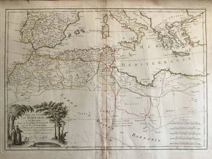
Sold2020Barbary coat. North west Africa. Morocco, Tunisia,Title: Barbary coat. North west Africa. Morocco, Tunisia, Algeria and Libya.. Date/Period: 1762 - 1771 Materials: Copperplate engraved Size: 20”x 14 1/2”. Barbary coast, shows North African countrSee Sold Price
Sold2020d'Urville, Dumont 1839 Lot of 6 Prints. North AfricaIncl Morocco, Algeria and Tunisia. Etchings Published 1834 by Chez Furne et Ce, Paris for "Voyage pittoresque autour du Monde - Résumé général des voyages de découvertes..." By Jules Dumont d'UrvSee Sold Price
Sold20181851 Tallis Map of North Africa -- Northern AfricaTitle/Content of Map: 1851 Tallis Map of North Africa -- Northern Africa Date: 1851, London Cartographer: J Tallis Size: 10 x 12.4 in. A very nice map of North Africa, including Tunisia, Algeria and MSee Sold Price
Sold2024PERSIA & AFGHANISTAN. South West Asia. Iran Baluchistan. JOHNSTON 1913 old mapCAPTION PRINTED BELOW PICTURE: 'Persia and Afghanistan' DATE PRINTED: 1913 IMAGE SIZE: Approx 34.5 x 45.0cm, 13.5 x 17.75 inches (Large); Please note that this is a folding map. TYPE: Antique colour aSee Sold Price
Sold20241837. Map of Barbary Coast. Northwest Africa. Morocco, Algeria, Libya and Tunisia. By A. PerrotTitle: 1837. Map of Barbary Coast. Northwest Africa. Morocco, Algeria, Libya and Tunisia. By A. Perrot Date/Period: 1837 Materials: Hand-colored steel engraving Size: 7 x 10 3/4” This is a map oSee Sold Price
Sold2021North Africa Nations Stamp CollectionNorth Africa Nations stamp collection. This collection contains 1 and a half double-sided sheets. Countries included are Morocco, Algeria, Mauritania and Tunisia. Please see photos.See Sold Price
Sold20231892 Black Map of Africa [on Separate Sheet] Morocco, Algeria to Tunisia [on Separate Sheet] EgyptTitle: 1892 Black Map of Africa [on Separate Sheet] Morocco, Algeria to Tunisia [on Separate Sheet] Egypt Cartographer: A&C Black Year / Place: 1892, Edinburgh Map Dimension (in.): 21.3 X 16.8 in. LarSee Sold Price
Sold2024Manchuria and Chosen'. The Korean peninsula & North East China 1913 old mapTITLE/CONTENT OF MAP: Manchuria and Chosen [Korea] DATE PRINTED: 1913 IMAGE SIZE: Approx 52.5 x 34.0cm, 20.5 x 13.25 inches (Large); Please note that this is a folding map. TYPE: Antique colour map COSee Sold Price
Sold2018Old Berber Leather hand bag fascinating embellishmentsThis is a beautiful antique leather satchel or hand bag from Morocco , North Africa. This hand bag was created and used by the Berber peoples and shows years of embellishments and decorative additionsSee Sold Price
Sold2018Old Berber Leather hand bag with fascinating adornmentThis is a beautiful antique leather satchel or hand bag from Morocco , North Africa. This hand bag was created and used by the Berber peoples and shows years of embellishments and decorative additionsSee Sold Price
Sold2024COLONIAL AFRICA. Kamerun borders reflect 1911 Treaty of Fez. JOHNSTON 1913 mapCAPTION PRINTED BELOW PICTURE: 'Africa' DATE PRINTED: 1913 IMAGE SIZE: Approx 35.5 x 44.0cm, 14 x 17.25 inches (Large); Please note that this is a folding map. TYPE: Antique colour atlas map; Scale 1:See Sold Price
Sold202117th C. French Engraving Map of N. Africa MoroccoFrench hand-colored engraving of North Africa, including Morrocco, parts of Algeria, Strait of Gibraltar. Dated 1655. Measures 16"H x 21"W visual image , 23.75"H x 27.75"W framed. Condition report: GoSee Sold Price
Sold2023MAP, Africa, MercatorNorthwestern Africa. Mercator/Hondius, Fessae Regnum, from Atlas Minor, 1609 (published). Hand Color. This charming small map of Morocco and Algeria extends south to Beninia and Nussini and includes tSee Sold Price
Sold2019Beni Mguild Pile RugFirst quarter 20th century, 380 x 170 cm, North Africa, Morocco, Middle Atlas Rather than a monochrome surface, the open field of this large Berber carpet presents the sum of various shades of crimsonSee Sold Price
Sold2021Rare Fossilized Rugops Raptor Killing Claw - Large!North Africa, Morocco, Kem Kem Formation, Middle Cretaceous Period, ca. 98 to 93 million years ago. An amazing, fossilized raptor claw, possibly from the Rugops genus of dinosaurs, a rare species thatSee Sold Price
Sold2018Rare Mesozoic Open Coil Heteromorph Ammonite FossilNorth Africa, Agadir, Morocco, mid-Cretaceous period, ca. 112 to 97 million years ago. Heteromorph or "uncoiled" ammonites are a type of cephalopod that are much more rare than typical solid coil ammoSee Sold Price
Sold2020Ait Ouaouzguite RugSecond quarter 20th century, 236 x 137 cm, North Africa, southern Morocco Comparatively fine in weave, this Berber rug is the work of the Ait Ouaouzguite tribe of the High Atlas region. The blue fieldSee Sold Price
Sold2017Levasseur: Antique Map of North America, 1840Title/Content of Map: 1840 Levasseur Map of North America - Amerique Septrentionale Date Printed: 1840 Paris Cartographer: V. Levasseur Size: 11 x 16.5 in. Condition: Excellent. Minor age toning; issuSee Sold Price
Sold2017Jaillot: Antique Map of North America, 1696Map: 1696 Jaillot Map of North America (California as an Island) -- Amerique Septentrionale Divisee en ses Principales Parties Date Printed: 1696 Amsterdam Cartographer: H. Jaillot Size: 19.3 x 23 in.See Sold Price
Sold2016Carthage Gold AV Stater, Zeugitana, North AfricaCarthage Gold AV Stater, Zeugitana, North Africa. Obverse head of Tanit left, wreathed in grain, wearing necklace and triple-drop earring, dot border. Reverse horse standing with three pellates and doSee Sold Price
Jul 06Case Antiques, Inc. Auctions & AppraisalsColton's Atlas of the World, 1856, in Two Volumes; plus Africa / Mahdist War MapUS$500
2 days LeftBroward Auction GalleryAdelaide Everhart (GA,NC,1865-1958) oil painting antiqueUS$30(3 bids)


![1892 Black Map of Africa [on Separate Sheet] Morocco, Algeria to Tunisia [on Separate Sheet] Egypt: Title: 1892 Black Map of Africa [on Separate Sheet] Morocco, Algeria to Tunisia [on Separate Sheet] Egypt Cartographer: A&C Black Year / Place: 1892, Edinburgh Map Dimension (in.): 21.3 X 16.8 in. Lar](https://p1.liveauctioneers.com/5584/279105/146836151_1_x.jpg?height=310&quality=70&version=1677020518)
![Manchuria and Chosen'. The Korean peninsula & North East China 1913 old map: TITLE/CONTENT OF MAP: Manchuria and Chosen [Korea] DATE PRINTED: 1913 IMAGE SIZE: Approx 52.5 x 34.0cm, 20.5 x 13.25 inches (Large); Please note that this is a folding map. TYPE: Antique colour map CO](https://p1.liveauctioneers.com/5584/318248/170784932_1_x.jpg?height=310&quality=70&version=1707248973)


