Sold2016Malte-Brun: Afrique Septentionale, 1812Map: Afrique Septentionale Maker: M Malte-Brun Date: 1812 Origin: Paris Size: 8.7 x 12.7 inches An excellent map of North Africa, rich with topographical and political division details. It shows the eSee Sold Price
Sold2017Malte-Brun: Antique Map of Northern Africa, 1812Map: 1812 Malte-Brun Map of Northern Africa -- Afrique Ancienne Cartographer: M Malte-Brun Year / Place: 1812, Paris Map Dimensions: 8.7 X 12.7 in. Condition: Very Good - Excellent. Color outlined onSee Sold Price
Sold2017Afrique Ancienne, 1812Map: Afrique Ancienne From Malte-Brun's Atlas Complet An excellent map of North Africa from approximately Biblical times. It shows the extend of the Sahara. A few of the very early cross-Sahara, routeSee Sold Price
Sold20171812 Malte-Brun Map of Siberian and Alaskan RussiaTitle: 1812 Malte-Brun Map of Siberian and Alaskan Russia -- Siberie avec lAmerique RussePartie Meridionale de la Russie d'Europe Cartographer: M Malte-Brun Origin/Date: 1812, Paris Size: 8.7 inches XSee Sold Price
Sold20171812 Malte-Brun Map of the Known WorldTitle: 1812 Malte-Brun Map of the Known World -- Systemes Geographiques de Ptolemee… Cartographer: M Malte-Brun Origin/Date: 1812, Paris Size: 8.7 inches X 11.7 inches An excellent and very interestSee Sold Price
Sold20201812 Malte-Brun Map of Ancient Civilized World -- MondeTitle/Content of Map: 1812 Malte-Brun Map of Ancient Civilized World -- Monde Connu des Anciens Cartographer: M Malte-Brun Year/Place: 1812, Paris Size: 8.7 X 11.7 in. An excellent map showing the geoSee Sold Price
Sold20191812 Malte-Brun Map of Germany -- Confederat du RhinTitle/Content of Map: 1812 Malte-Brun Map of Germany -- Confederat du Rhin Date: 1812, Paris Cartographer: M Malte-Brun Size: 11.7 x 8.8 in. An attractive map of German states, showing its political dSee Sold Price
Sold20201812 Malte-Brun Map of Scandinavia -- Danemark Suede etTitle/Content of Map: 1812 Malte-Brun Map of Scandinavia -- Danemark Suede et Norwege Cartographer: M Malte-Brun Year/Place: 1812, Paris Size: 11.7 x 8.8 in. A handsome map of Scandinavia. Finland isSee Sold Price
Sold20171812 Malte-Brun Double Map of Europe in 1500s and 1789Item: 1812 Malte-Brun Double Map of Europe in 1500s and 1789 Description: An interesting double map of Europe in the the period of Charles V's reign in the first half of 1500s and Europe in 1789. MostSee Sold Price
Sold2017Malte-Brun: Antique Map of the World per Herodotus 1812Title/Content of Map: 1812 Malte-Brun Map of the Known World per Herodotus -- Geographie d'Herodote Date Printed: 1812, Paris Cartographer: M Malte-Brun Size: 8.7 X 11.7 in. An excellent and very inteSee Sold Price
Sold2017Malte-Brun: Map of Europe during Hun invasion in 370Map: 1812 Malte-Brun Map of Europe during the Hun invasion in 370 -- L'Europe avant l'invasion des Huns vers l'an 370 Date Printed: 1812, Paris Cartographer: M Malte-Brun Size: 8.7 X 11.7 in. ConditioSee Sold Price
Sold2017Malte-Brun: Antique Double Map of Europe in 1500 & 1789Title/Content of Map: 1812 Malte-Brun Map Double Map of Europe in 1500s and 1789 -- Europe sons Charles-Quint [together with] Europe en 1789 Date Printed: 1812, Paris Cartographer: M Malte-Brun Size:See Sold Price
Sold2017Malte-Brun: Map of North France Belgium & Holland, 1812Map: 1812 Malte-Brun Map of Northern France, Belgium and Holland -- Partie Septentrionale de l'Empire Francis Cartographer: M Malte-Brun Year / Place: 1812, Paris Dimensions: 8.7 X 11.7 in. Condition:See Sold Price
Sold2017Malte-Brun: Antique Map of Portugal & Spain, 1812Title/Content of Map: Portugal with parts of Western Spain Date Printed: 1812 Cartographer: Malte-Brun Material/Medium: Paper Size: 10" x 13 1/2" Published in Paris Conrad Malte-Brun (1775 - 1826), boSee Sold Price
Sold2017Malte-brun: Double Map of Europe in 900 and 1100, 1812Malte-brun Map Double Map of Europe in 900 and 1100 -- Europe En 900 [together With] Europe En 1100. 1812, Paris. 8.7 X 11.7 in. An interesting double map of Europe in the middle ages -- 900 and 1100.See Sold Price
Sold2023Carte de L'Afrique. Map of Africa. Takrur Guinea Congo. MALTE-BRUN c1871TITLE/CONTENT OF MAP: 'Carte de l'Afrique [Map of Africa]' DATE PRINTED: c1871 IMAGE SIZE: Approx 35.0 x 45.0cm, 13.75 x 17.75 inches (Large); Please note that this is a folding map. TYPE: Antique 19tSee Sold Price
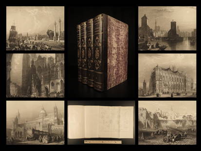
Sold20221841 BEAUTIFUL Geography by Malte-Brun Illustrated1841 BEAUTIFUL Geography by Malte-Brun Illustrated Jerusalem Edinburg Ruins 4v Conrad Malte-Brun was a French geographer and cartographer known for his impressive journal-like atlases and geography boSee Sold Price
Sold2017Malte-Brun: Map of Asia, 1830Map: Asia Maker: John Grigg, Malte-brun, Conrad/j. H. Young, Sc. Publication Date: 1830 Publisher: John Grigg Size: Quarto – 8.00 H x 9.75 W Inches From Malte-Brun's "A new General atlas, exhibitingSee Sold Price
Sold2017Malte-Brun: Map of Europe, Barbarian Invasions, 1811Map: 1811 Malte-Brun Map of Europe during the Barbarian Invasions -- L'Europe apres l'invasion des Barbares Cartographer: M Malte-Brun Year / Place: 1811, Paris Map Dimensions: 8.7 X 11.7 An outstandiSee Sold Price
Sold2018Malte-Brun: Antique Map of Central Oceanica, 1830Title/Content of Map: Central Oceanica Date Printed: 1830 Cartographer: MALTE-BRUN, CONRAD/J. H. YOUNG, sc. Size (inches): 7.5x7.5 From Malte-Brun's "A new General atlas, exhibiting the five great divSee Sold Price
Sold2017Malte-Brun: Antique Map of Europe in 1829Title/Content of Map: 1829 Malte-Brun Map of Europe in 1829 -- Europe en 1829 Date Printed: 1829, Paris Cartographer: M Malte-Brun Size: 8.7 X 11.7 in. An attractive map of Europe showing its politicaSee Sold Price
Sold20171834 Malte-Brun Map of Ireland1834 Malte-Brun Map of Ireland -- Ireland. M. Malte-Brun / S. Walker. 1834, Boston. 9.3 x 7.5 in. An attractive and highly detailed map with topographical and settlement details. From the American ediSee Sold Price
Sold2017Malte-Brun: Antique Map of Italy, 1834Title/Content of Map: 1834 Malte-Brun Map of Italy -- Italy Date Printed: 1834, Boston Cartographer: M. Malte-Brun / S. Walker Size: 9.3 x 7.5 in. An attractive and highly detailed map with topographiSee Sold Price
Sold2017Malte-Brun Map of the Spice Islands, 18341834 Malte-Brun Map of the Spice Islands -- East India Islands (S China Sea). An attractive and highly detailed map the East India Islands with topographical and settlement details. From the AmericanSee Sold Price
Jun 02Carlsen Gallery, Inc.MOHAWK VALLEY PAINT DECORATED BLANKET CHEST SHOE FOOT, ALL ORIGINAL (181/2" X 43" X 17")US$500
87 Lots AwayUniversity ArchivesJames Monroe During War of 1812: "You know but little of the heavy pressure…"US$1,000
88 Lots AwayUniversity ArchivesJames Monroe DS as Sec. of State: Instructions for Public and Private Armed Vessels, 1812US$300(1 bid)
3 days LeftBlackstone Valley Auctions & Estates LLCWar of 1812 Era Cartridge Box with Tin Tubes.US$150
Swann Auction GalleriesVigée Le Brun, Élisabeth (1755-1842) Memoirs of Madame Vigée Lebrun, in a Deluxe CoswUS$5,000(3 bids)
Jun 02Schilb Antiquarian Rare Books1833 President Andrew Jackson Military Politics US Revolutionary War of 1812US$4(3 bids)
4 days LeftThe Heritage Gallery at Sayville Antiques, IncSCHWEIZER MUSTERMESSE BASEL Poster Donald BrunUS$50(1 bid)
3 days LeftTrillium Antique Prints & Rare BooksLe Brun - 4 Lithographs portraying Man as AnimalUS$75(1 bid)
1 day LeftPotter & Potter AuctionsAUDIBERTI, J. Choain. Afrique Equatoriale Francaise. Paris:...US$100(1 bid)
421 Lots AwayHermann Historica GmbHAn English silver tankard with cover, Sheffield, 1812See Sold Price
1 day LeftPotter & Potter AuctionsGUERRA, Vincent. Air France / Afrique Occidentale. Paris: A...US$300
3 days LeftClars Auction GalleryA Federal style eglomise mirror with titled naval scene of the Constitution [sic] & Guereriere 1812US$20


![Malte-Brun: Antique Double Map of Europe in 1500 & 1789: Title/Content of Map: 1812 Malte-Brun Map Double Map of Europe in 1500s and 1789 -- Europe sons Charles-Quint [together with] Europe en 1789 Date Printed: 1812, Paris Cartographer: M Malte-Brun Size:](https://p1.liveauctioneers.com/5584/112159/57581953_1_x.jpg?height=310&quality=70&version=1510710796)


![Malte-brun: Double Map of Europe in 900 and 1100, 1812: Malte-brun Map Double Map of Europe in 900 and 1100 -- Europe En 900 [together With] Europe En 1100. 1812, Paris. 8.7 X 11.7 in. An interesting double map of Europe in the middle ages -- 900 and 1100.](https://p1.liveauctioneers.com/5584/102658/52470396_1_x.jpg?height=310&quality=70&version=1492118289)
![Carte de L'Afrique. Map of Africa. Takrur Guinea Congo. MALTE-BRUN c1871: TITLE/CONTENT OF MAP: 'Carte de l'Afrique [Map of Africa]' DATE PRINTED: c1871 IMAGE SIZE: Approx 35.0 x 45.0cm, 13.75 x 17.75 inches (Large); Please note that this is a folding map. TYPE: Antique 19t](https://p1.liveauctioneers.com/5584/308981/165185437_1_x.jpg?height=310&quality=70&version=1699996168)


![A Federal style eglomise mirror with titled naval scene of the Constitution [sic] & Guereriere 1812 (1 of 1)](https://p1.liveauctioneers.com/306/329433/177664976_1_x.jpg?height=282&quality=70&version=1715393381)