Sold2017Map of Detroit and Vicinity, 1898Map: Detroit and Vicinity Rand, McNally & Co. 1898 New Standard Atlas of the World Size: 28 x 21.5 inches No Reserve: This lot starts at $1 and has no reserve as a courtesy so that collectors can deteSee Sold Price
Sold2022Alaska Map, 1898 [155038]1898 Alaska route of military expedition in charge of Captain EF Glenn, from Knik Arm to Tanana River. 31x12".Date: Country (if not USA): State: AlaskaCity: Provenance:See Sold Price
Sold2023Williamson, Lieut. R. S. 1856 Map. Vicinity of San Francisco California"Geological Map of the Vicinity of San Francisco" by William P. Blake. Lithograph Map Published 1853-61, Washington for "Reports of explorations and surveys, to ascertain the most practicable and econSee Sold Price
Sold20201898 Rand McNally Chart of World Flags -- [World Flags]Title/Content of Map: 1898 Rand McNally Chart of World Flags -- [World Flags] Cartographer: Rand McNally Year/Place: 1898, Chicago Size: 12.5 X 9.2 in. This is a very nice chart of 60 world flags, orgSee Sold Price
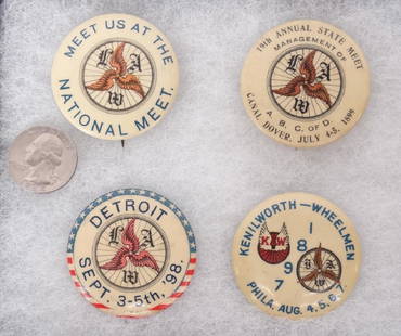
Sold2018Wheelmen PinbacksLot (4) Wheelmen pinbacks. Detroit 1898, Canal Dover 1899, Philadelphia 1897. 1 3/4" each. Good condition. Case included.See Sold Price
Sold2023Signed 19th Century Detroit Harbor PaintingAn exceptional and large painting of a boy fishing. The bottom right corner is signed H.R ANDERSON / DETROIT 1898. In the background the painting features a skyline. Some deep areas of crackolier. AnSee Sold Price
Sold20201898 Rand McNally Chart of Tallest Buildings -- NotableTitle/Content of Map: 1898 Rand McNally Chart of Tallest Buildings -- Notable High Buildings of the World Cartographer: Rand McNally Year/Place: 1898, Chicago Size: 12.5 X 9.2 in. This is a very niceSee Sold Price
Sold20201898 Rand McNally Map of Texas and IndianTitle/Content of Map: 1898 Rand McNally Map of Texas and Indian Territory/Oklahoma -- Texas; Oklahoma and Indian Territory Date: 1898, Chicago Cartographer: Rand McNally Size: 9.2 x 12.5 in. This mapSee Sold Price
Sold2017Rand McNally Map India, Burma, Nepal and Ceylon, 1898Map: 1898 Rand McNally India, Burma, Nepal and Ceylon -- India Cartographer: Rand McNally Year / Place: 1898, Chicago Map Dimension: 26.2 X 19.2 in. A very nice map of South East Asia. Highly detailedSee Sold Price
Sold20191898 Rand McNally Map of Louisiana -- [Louisiana]Title/Content of Map: 1898 Rand McNally Map of Louisiana -- [Louisiana] Date: 1898 Chicago Cartographer: Rand Mcnally Size: 13 X 19.4 in. This is a highly detailed, larger map of Lousiana. It color coSee Sold Price
Sold20201898 Rand McNally Map of Asia from China, Japan toTitle/Content of Map: 1898 Rand McNally Map of Asia from China, Japan to Indonesia -- China, French Indo-China, Siam, Malaysia & Korea Cartographer: Rand McNally Year/Place: 1898, Chicago Size: 18.6 xSee Sold Price
Sold2017Map of Hawaii and the Philippines, 1898Map: 1898 Map of Hawaii and the Philippines -- The Philippine Islands and Hawaii Cartographer: Century Co. Year / Place: 1898, New York Map Dimensions: 10.4 x 14.7 in. An unsual, rare and interestingSee Sold Price
Sold20201898 c. Cram View of the Proposed Nicaraguan Canal --Title/Content of Map: 1898 c. Cram View of the Proposed Nicaraguan Canal -- Birds Eye View of the Maritime Canal of Nicaragua Cartographer: G Cram Year/Place: 1898 c., Chicago Size: 7.8 X 12.4 in. ThiSee Sold Price
Sold20191898 Rand McNally Map of San FranciscoTitle/Content of Map: 1898 Rand McNally Map of San Francisco Date: 1905, Chicago Cartographer: Rand McNally Size: 13.5 x 11 in. A very nice map od San Francisco from the late 19th century. The map comSee Sold Price
Sold20201898 Rand McNally Map of Utah [verso] Wyoming -- UtahTitle/Content of Map: 1898 Rand McNally Map of Utah [verso] Wyoming -- Utah [verso] Wyoming Cartographer: Rand McNally Year/Place: 1898 Chicago Size: 12.2 X 9.3 in. This is very nice map of Utah and WSee Sold Price
Sold20201898 Rand McNally Map of the United States -- UnitedTitle/Content of Map: 1898 Rand McNally Map of the United States -- United States Cartographer: Rand McNally Year/Place: 1898, Chicago Size: 9.2 X 12.4 in. This is a quite detailed political map of thSee Sold Price
Sold20201898 Rand McNally Map of the United States -- UnitedTitle/Content of Map: 1898 Rand McNally Map of the United States -- United States Cartographer: Rand McNally Year/Place: 1898, Chicago Size: 9.2 X 12.4 in. This is a quite detailed political map of thSee Sold Price
Sold2024Detroit 1889Title/Content of Map: Detroit 1889 Date Printed: 1889 Material/Medium: paper Size: Approx. 14.5x10.5 inches Cram's Unrivaled Atlas of the World. W.H. Stewart Publisher, Rochester Reserve: $35.00 ShippSee Sold Price
Sold2024Detroit 1895Title/Content of Map: Detroit 1895 Date Printed: 1895 Material/Medium: paper Size: approx. 13.5"x11" Rand McNally & Co. Universal Atlas of the World Reserve: $35.00 Shipping: Domestic: Flat-rate of $See Sold Price
Sold20181898 Cram Map of Toronto -- TorontoReserve Reduced! Title/Content of Map: 1898 Cram Map of Toronto -- Toronto Date: 1898, Chicago Cartographer: G Cram Size: 9.6 X 12 in. This is a nice, and highly detailed map of Toronto. Shown are roaSee Sold Price
Sold20191898 Cram map of the Bahamas [verso] Haiti, DominicanTitle/Content of Map: 1898 Cram map of the Bahamas [verso] Haiti, Dominican Republic and Jamaica -- Map of the Bahama Islands [verso] Map of Jamaica, Haiti and San Domingo Date: 1898, ChicagoCartograpSee Sold Price
Sold20221898 Map of WorcesterMatte 24" x 36". Map 21" x 31" Please see photos and come to the 2 day preview for condition.See Sold Price
Sold2024Union Trust Co. Map of DetroitAn early 20th century Union Trust Company map of Detroit. Lithograph with colors map, printed by the National Lithograph Co. of Detroit. Rippling, some creases and toning. Mounted to a wooden stretcheSee Sold Price
Sold20221842 US Army Map of Lake St. Clair by Detroit -- Map of the Delta of the St. Clair…Title: 1842 US Army Map of Lake St. Clair by Detroit -- Map of the Delta of the St. Clair… Cartographer: US Army Year/Place: 1842 Dimensions: 27.8 X 47 in. Description: This superb and quite uncSee Sold Price
19 hrs LeftJasper52HAWAII HISPANIOLA. Hawaiian Isles; Haiti San Domingo Dominican Republic 1898 mapUS$20
19 hrs LeftJasper52West Indies and Central America; Inset British Guiana. Caribbean 1898 old mapUS$15
19 hrs LeftJasper52CARIBBEAN. West Indies & Central America. Britannica 9th edition 1898 old mapUS$20
May 16Potter & Potter AuctionsPictorial Map of Hollywood and Vicinity / Hollywood Film Ca...US$125(1 bid)
7 days LeftJasper521898 Rand McNally Map of Texas [verso] Indian Territory and Oklahoma -- Texas [verso] Oklahoma andUS$70
2 days LeftRail & Road AuctionsFour Early 1900s Steamship Timetables and Travel Brochures - Detroit & Cleveland, Dominion AtlanticUS$20
May 16DuMouchellesGlobe of the World, Mahogany Frame, by Weber Costello Co., H 40" Dia. 23"US$150(1 bid)


![Alaska Map, 1898 [155038]: 1898 Alaska route of military expedition in charge of Captain EF Glenn, from Knik Arm to Tanana River. 31x12".Date: Country (if not USA): State: AlaskaCity: Provenance:](https://p1.liveauctioneers.com/2699/258185/134287533_1_x.jpg?height=310&quality=70&version=1660347389)

![1898 Rand McNally Chart of World Flags -- [World Flags]: Title/Content of Map: 1898 Rand McNally Chart of World Flags -- [World Flags] Cartographer: Rand McNally Year/Place: 1898, Chicago Size: 12.5 X 9.2 in. This is a very nice chart of 60 world flags, org](https://p1.liveauctioneers.com/5584/173638/87405912_1_x.jpg?height=310&quality=70&version=1594766493)


![1898 Rand McNally Map of Louisiana -- [Louisiana]: Title/Content of Map: 1898 Rand McNally Map of Louisiana -- [Louisiana] Date: 1898 Chicago Cartographer: Rand Mcnally Size: 13 X 19.4 in. This is a highly detailed, larger map of Lousiana. It color co](https://p1.liveauctioneers.com/5584/133765/67934968_1_x.jpg?height=310&quality=70&version=1546475054)


![1898 Rand McNally Map of Utah [verso] Wyoming -- Utah: Title/Content of Map: 1898 Rand McNally Map of Utah [verso] Wyoming -- Utah [verso] Wyoming Cartographer: Rand McNally Year/Place: 1898 Chicago Size: 12.2 X 9.3 in. This is very nice map of Utah and W](https://p1.liveauctioneers.com/5584/182355/91727155_1_x.jpg?height=310&quality=70&version=1603285541)


![1898 Cram map of the Bahamas [verso] Haiti, Dominican: Title/Content of Map: 1898 Cram map of the Bahamas [verso] Haiti, Dominican Republic and Jamaica -- Map of the Bahama Islands [verso] Map of Jamaica, Haiti and San Domingo Date: 1898, ChicagoCartograp](https://p1.liveauctioneers.com/5584/144953/73284241_1_x.jpg?height=310&quality=70&version=1562102885)


![1898 Rand McNally Map of Texas [verso] Indian Territory and Oklahoma -- Texas [verso] Oklahoma and (1 of 2)](https://p1.liveauctioneers.com/5584/328338/176911581_1_x.jpg?height=282&quality=70&version=1715113718)


