Sold2018Map of Patagonia & Falkland Islands, 1859Title/Content of Map: Patagonia & Falkland Is. Date Printed: 1859 Cartographer: Material/Medium: Paper Size: 14 x 17" Provenance: New York Please note that this lot has a confidential reserve. When yoSee Sold Price
Sold2023Map of 1859. Patagonia, Falkland Islands by ColtonTitle: Map of 1859. Patagonia, Falkland Islands by Colton Date/Period: 1859 Materials: Hand colored steering engraved Size: 17 1/2 x 14 1/2” br>Patagonia is still not controlled by Chile or ArgeSee Sold Price
Sold2017Colton: Antique Map of Patagonia, Falkland Islands 1861Title/Content of Map: Patagonia, Falkland Islands Date Printed: 1861 Cartographer: J.H. Colton Material/Medium: Paper Size: 17 1/2" x 14" Hand colored, steel engraved. From 'Colton's General Atlas.' PSee Sold Price
Sold2017Tallis: Antique Map Falkland Islands & Patagonia, 1851Title/Content of Map: 1851 Tallis Map of Falkland Islands and Patagonia -- Falkland Islands and Patagonia Date Printed: 1851, London Cartographer: J Tallis Size: 13.3 x 9.6 in. A very attractive map iSee Sold Price
Sold2021Tallis, John (Pub) 1852 Map Falkland Islands, PatagoniaSteel Engraved Map with Original Outline Hand Color Published 1852-56 by John Tallis, London for "The Universal Pronouncing Dictionary" by Thomas Wright. Drawn & Engraved by John Rapkin. Centre fold aSee Sold Price
Sold2018Bellin: Patagonia / Magellanica / Falkland Islands 1753Carte Reduite de la Partie la plus Meridionale de l'Amerique Bellin's detailed map of the "southernmost part of America"— Patagonia, Tierra del Fuego, and the Falkland, or Malouine, islands, from thSee Sold Price
Sold2018Meyer: Patagonia, Magellanica, Falkland IslandsReserve Reduced! Title of Map: Sudlichster Theil von America enthaltend Patagonia, Feuerland & Falklands Gruppe 1857 Cartographer: Joseph Meyer / Bibliographischen Instituts Place / Date: HildburghausSee Sold Price
Sold2019Falkland Islands And Patagonia.Title: Falkland Islands And Patagonia. Publication Date: 1850 Cartographer: RAPKIN, J. Publisher: TALLIS, J. & F.Size: 13.5Height - 9.75Width Interesting maps of southern Argentina decorated with vignSee Sold Price
Sold2016Patagonia, South Orkney, South Georgia & FalklandOriginal engraving by Colton, 1875. Map features insets of South Orkney, South Georgia & Falkland Islands. Dimensions: 13 3/4" x 17 1/4" Shipping Domestic: Shipping rates are determind by destination.See Sold Price
Sold2018Map of Falkland IslandsReserve Reduced! Title/Content of Map: Map of Falkland IslandsDate: 1770 Cartographer: LODGE, J. Material/Medium: D. HENRY/F. NEWBERY Size: 6.5 x 9.3 inches in the latitude of 51 deg. 22' South, longiSee Sold Price
Sold20241756 Port Julian, River, and True Justice Island, Patagonia, Argentina Map by G. AnsonTitle: 1756 Port Julian, River, and True Justice Island, Patagonia, Argentina Map by G. Anson Date/Period: 1756 Materials: Copper plate engraved Size: 18? x 11? This 1756 map showcases the view of PorSee Sold Price
Sold2018Colton: Antique Map, Sizes of Lakes and Islands, 1859Title/Content of Map: Sizes of Lakes and Islands by Colton Date Printed: 1859 Cartographer: H.J. Colton Material/Medium: Paper Size: 17 1/2" x 15" Hand colored steel engraved Map. From 'Colton's GenerSee Sold Price
Sold2024SOUTH AMERICA. Inset Buenos Aires Valparaiso Falklands Rio de Janeiro 1891 mapTITLE/CONTENT OF MAP: 'South America; Inset maps of Buenos Ayres; Valparaiso; Falkland Islands; Rio de Janeiro' DATE PRINTED: 1891 IMAGE SIZE: Approx 46.5 x 32.5cm, 18.25 x 12.75 inches (Large); PleasSee Sold Price
Sold2023S AMERICA. Bolivia-Paraguay Gran Chaco border dispute. Chile Argentina 1920 mapTitle: S AMERICA. Bolivia-Paraguay Gran Chaco border dispute. Chile Argentina 1920 map Description: South America ( Section III ); Inset Falkland Islands' by Harmsworth (1920). Vintage colour map, 34.See Sold Price
Sold2024Argentina Chile Uruguay. Buenos Ayres plan. South America. TIMES 1957 old mapTITLE/CONTENT OF MAP: 'Argentina // Chile // Uruguay // Buenos Aires // South Georgia // Falkland Islands // South Sandwich Islands' DATE PRINTED: 1957 IMAGE SIZE: Approx 47.5 x 59.5cm, 18.75 x 23.25See Sold Price
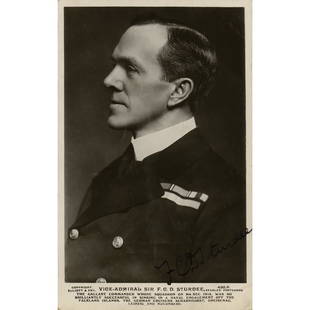
Sold2022Doveton Sturdee Signed PhotographRoyal Navy officer (1859-1925) celebrated for his success against the Imperial German Navy at the Battle of the Falkland Islands during World War I. Vintage glossy 3.5 x 5.5 photo of Vice Admiral SturSee Sold Price
Sold2017South America From Original Documents......Including the Survey by the Officers of H. M. Ships Adventure and Beagle (London: John Arrowsmith, 1839), with inset maps showing the Galapagos Islands, Port San Carlos, the Falkland Islands, and TSee Sold Price
Sold2023New Zealand Sandwich Galapagos Islands. Papuan Archipelago. Melanesia 1859 mapNew Zealand. // Sandwich Islands, or Hawaiian Group, // Galapagos Islands // Papuan Archipelago' by John Bartholomew (1859). Antique engraved atlas map with original hand colour/color, 37.0 x 53.5cm,See Sold Price
Sold2023Framed Map of Long Island by George H. Moore, The Dukes Plan 1859Framed Map of Long Island by George H. Moore, The Dukes Plan 1859. This is an excellent framed map of Long "Isleland." It is labeled, "The Dukes Plan." And it is, "A Description of the towne of MannadSee Sold Price
Sold20231859 Map of Massachusetts and Rhode Island. Insert of Boston by ColtonTitle: 1859 Map of Massachusetts and Rhode Island. Insert of Boston by Colton1859 Materials: Steel engraved Size: 17 1/2 x 14 1/2” Massachusetts and Rhode Island. With insert of Boston and surroundiSee Sold Price
Sold20231974 Falkland Islands Gold Coin Proof Set 1.85oz.Royal mint in original packaging.See Sold Price
Sold20231995 Falkland Islands V.E. Day Gold Coin Proof 47.54 g 22KTProof in original box. With COASee Sold Price
178 Lots AwayMynt Auctions1943 Port Stanley Falkland island Cover to Clarion IA USA Via Uruguay CensoredUS$530
1 day LeftJasper52COREA JAPAN FORMOSA. Korea Taiwan Hachijo "penal settlement".JOHNSTON 1897 mapUS$55
6 hrs LeftJasper521822 MAP of LEEWARD ISLANDS GEOGRAPHICAL STATISTICAL HISTORICAL antique 17.5x22"US$120
6 hrs LeftJasper521760 MAP CARTE PARTICULIERE DE L'ISLE DE JUAN FERNANDES antique Robinson CrusoeUS$55
Jun 08Leon GalleryRobert Dudley (1573 - 1649) - Carta particolare del'Isola Mindano parte Australe con Celebes e₱500,000
4 days LeftTrillium Antique Prints & Rare BooksSanson - Map of the Sunda Islands, Sumatra, Java, & BorneoUS$75
4 days LeftTrillium Antique Prints & Rare BooksSanson - Map of the Philippines and Ladrones IslandsUS$75
1 day LeftJasper52SOUTH ASIA. India Ceylon Sri Lanka Indochina Maldives. 'Inde'. MALLET 1683 mapUS$60
Featured7 hrs LeftJasper521764 Bellin Map of Lesser Antilles Northern Portion -- Petites Antilles ou Isles du Vent 3e. Partie.US$130
1 day LeftJasper52Les Indes Orientales… South Asia India Indochina. SANTINI / VAUGONDY 1784 mapUS$85
4 days LeftTrillium Antique Prints & Rare BooksDe Jode, Rare, pub. 1593 - Map of Europe (Nova Totius Europae Tabula)US$160(4 bids)
Featured1 day LeftJasper52Suite de l’Ocean Oriental…' East Asia/Indies. Western Pacific. BELLIN 1746 mapUS$200