Sold2019Map of Ukraine and Crimea, 1740Heading: Author: Seutter, Matthew Title: Theatrum Belli Russorum Victoriis illustratum sive Nova et accurata Turcicarum et Tartaricum... Place Published: Augsburg Publisher: Date Published:See Sold Price
Sold20231730 MAP UKRAINE CRIMEA RUSSIA BLACK & AZOV SEA antique NOVA MAPPA GEOGRAPHICANOVA MAPPA GEOGRAPHICA MARIS ASSOVIENSIS vel de ZABACHE et PALUDIS MAEOTIDIS accuratè aeri incisa et in lucem edita per Matthaeum Seutter chalcograph. Augsburg; 1730 Overall size 21.5 by 25.5" ImSee Sold Price
Sold2017Sanson: Antique Map Crimea / Ukraine, 1665Map: Antique Map Crimea / Ukraine -- Cimmeria quae Postea Scythia Europaea seu Parua Scythia… Cartographer: N. Sanson / P. Mariette Year / Place: 1665-94. Paris Dimensions: 15.7 x 19 in. Condition:See Sold Price
Sold2021Rapkin, John 1857 Map of The Crimea. Ukraine RussiaSteel Engraved Map Published 1857, London for "England's Battles by Sea and Land..." by Lieut-Colonel Williams. Centre fold as issued. Drawn & Engraved by John Rapkin. Paper Size: 14 x 10.5 inch (36 xSee Sold Price
Sold2021Rapkin, John 1857 Map of The Crimea. Ukraine RussiaSteel Engraved Map Published 1857, London for "England's Battles by Sea and Land..." by Lieut-Colonel Williams. Centre fold as issued. Drawn & Engraved by John Rapkin. Paper Size: 14 x 10.5 inch (36 xSee Sold Price
Sold2019Tallis (Pub) 1858 Map of The Crimea. Russia UkraineSteel Engraved Map Published 1858 by the London Printing and Publishing Co., London for "The History Of The War With Russia: Giving Full Details Of The Operations Of The Allied Armies" by Henry TyrrelSee Sold Price
Sold2019MAP - Ukraine. MercatorUkraine. Mercator/Hondius, Taurica Chersonesus, 1613 (published). Hand Color. Lovely miniature map of the region north of the Black Sea encompassing the Crimea and the southern steppes of Ukraine. TheSee Sold Price
Sold2018Mortier: Antique Map of Crimea & South Russia, 1705Title/Content of Map: Crimea and Southern Russia Ukraine area during classical times Date Printed: 1705-06 Cartographer: Pierre Mortier Material/Medium: Paper Size: 17" x 23 2/3" Antique Map. CopperplSee Sold Price
Sold2017Seutter: Opulentissimum Sinarum Imperium Map, 1740Opulentissimum Sinarum Imperium. Asia with Korea as Peninsula map by M. Seutter, 1740 (62.5 x 52.5 cm) Please note that this lot has a confidential reserve. When you leave a bid in advance of the auctSee Sold Price
Sold2017Homann: British West Indies/Atlantic Islands Map, 1740Map: Dominia Anglorum. British West Indies/Atlantic islands of St Christopher (St Kitts), Antigua, Bermuda, Jamaica & Barbados Date Printed: c1740 Image Size: Approx 52.5 x 59.5cm, 20.5 x 23.25 inchesSee Sold Price
Sold2018Western or Atlantic Ocean Color Map 1740A New Map or Chart of the Western or Atlantic Ocean, with part of Europe, Africa & America. 1740. Printed for E. Cave, London. 15" x 12". We ship all items in this auction in-house with the most fairSee Sold Price
Sold2022Maps, Ukraine and Westfalia(lot of 2) European School (19th century), Maps of Ukraine and Westfalia, etchings on load paper, unsigned, overall (with frame/each): 29"h x 32.5"wSee Sold Price
Sold20181740 Seutter Map of Japan -- Imperium Japonicum perTitle/Content of Map: 1740 Seutter Map of Japan -- Imperium Japonicum per Sexaginta et Sex Regiones Digestum atque ex Ipsorum Japonensium Mappis Descriptum … Date: 1740 c., Augsburg Cartographer: MSee Sold Price
Sold20181740 Rupprech/Haffner Antique View of LondonTitle/Content of Map: 1740 Rupprech/Haffner View of London -- Lodinium [or] Prospectus Londinum, Sedes Regia, et praecipua Urbs in Anglia ad Temesium Fluvium . . . Date Printed: 1740 c. Augsburg CartoSee Sold Price
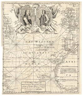
Sold20171740 Ornate Copperplate Engraved Portrait MapHistoric Maps 1740 Ornate Copperplate Engraved Map with Portraits of British Admirals “Robert Blake” & “Edward Vernon, Esq.” 1740-Dated, Copperplate Engraved Map titled “A New Map or Chart oSee Sold Price
Sold2017Rupprech/Haffner: Antique Map View of Geneva, 1740Title/Content of Map: 1740 Rupprech/Haffner View of Geneva -- Genf Date Printed: 1740 c. Augsburg Cartographer: MA Rupprecht / J C Haffner Size: 12 x 15.6 in. A rare "vue d'optique" (with mirror imageSee Sold Price
Sold2022With folding map of Crimea and the Black SeaHeading: Author: Seymour, H.D. Title: Russia on The Black Sea and Sea of Azof: Being a Narrative of Travels in the Crimea and Bordering Provinces; with Notices of the Naval, Military, and CommercialSee Sold Price
Sold20231739 EARLY America CRIMEA Map Whitefield INDIANS Jamaica Gentlemans Magazine1739 EARLY America CRIMEA Map Whitefield INDIANS Jamaica Gentlemans Magazine The Gentlemans Magazine was an English periodical which first appeared in 1731. It was published without interrupt for nearSee Sold Price
Sold2021H. Moll, circa 1740, Map of Turkish EmpireDedicated to the Honourable Tho. Vernon, Esq. Constructed in 4 panels. Hand colored. Wrinkling and tears to edges. Large tear and panel detachment to middle. Waterdamage and mold to upper middle of maSee Sold Price
Sold2022Vivianite Clam Shell Fossil From Kerch Crimea UkraineVivianite clam shell fossil from kerch Ccrimea ukraineSee Sold Price
Sold2023England, 19th century. A map of Crimea by H.G. Collins, London, c. 1854. Pasted on thin linen withEngland, 19th century. A map of Crimea by H.G. Collins, London, c. 1854. Pasted on thin linen with adhesive for stability. Measures 25 x 19 inches; some loss at bottom right corner.See Sold Price
Sold2021Pluche, Noel 1740 Map of the Phenician ColoniesCopper Engraved Map Published 1740, London for "Spectacle de la Nature..." by Noel Antoine Pluche. Folds as issued. Paper Size: 9.5 x 7.5 inch (24 x 19cm) Minor offsetting in margin. Good ConditionSee Sold Price
Sold2022John Senex Map of Louisiana & Mississippi River 1721John Senex (English, 1678-1740). "Map of Louisiana and the River Mississippi," from "A New General Atlas," London, 1721. Dedicated to William Law of Lanreston. This map is an EngliSee Sold Price
Sold2021Holy land by Stoopendaal, Bible map. 1738-1740,Title: Holy land by Stoopendaal, Bible map. 1738-1740, Rotterdam Date/Period: 1738-1740 Materials: Copperplate engravedSize: 18” x 13”. Canaan / Holy land (oriented with north to the right). By DaSee Sold Price
5 days LeftWhite Knight Auction, IncAlexander Galtchansky and Tanya Wissotzky, 'Ladies I' Hand Signed Limited Edition Serigraph on PaperUS$80
5 days LeftWhite Knight Auction, IncAlexander Galtchansky and Tanya Wissotzky, 'EVENING BOUQUET' Hand Signed Limited Edition SerigraphUS$80
5 days LeftWhite Knight Auction, IncAlexander Galtchansky and Tanya Wissotzky, 'Chinese Vase' Hand Signed Limited Edition SerigraphUS$80
5 days LeftWhite Knight Auction, IncAlexander Galtchansky and Tanya Wissotzky, 'Passing Thought' Hand Signed Limited Edition SerigraphUS$80
Featured4 days LeftJasper521792 Elwe Map of Southern Russia in Europe -- Partie Meridionale de Moscovie Dresse par G. De L'IsleUS$190
4 days LeftJasper521736 LARGE MAP OF SILESIA POLAND SAGANENSIS antique 25 x 4 3/4" Duchy of KrnovUS$260
346 Lots AwayJeschke Jadi Auctions Berlin GmbHSammlung von zwei altkolorierten Kupferstichkarten. 18. Jh. Maße je ca. 53 x 65 cm.€200
May 04Trillium Antique Prints & Rare BooksAlbin - Pair of Bird Engravings: Goosander & SheldrakeUS$40
May 14Fleischer's Auctions1755 Map Partie de l'Amerique Septentrionale, qui comprend Le Cours de L'Ohio...US$200(3 bids)
May 05Tremont AuctionsJohn Speed and Francis Lamb "Map of New England and New York", ca. 1676. Hand colored engraved mapUS$900(3 bids)


![1740 Rupprech/Haffner Antique View of London: Title/Content of Map: 1740 Rupprech/Haffner View of London -- Lodinium [or] Prospectus Londinum, Sedes Regia, et praecipua Urbs in Anglia ad Temesium Fluvium . . . Date Printed: 1740 c. Augsburg Carto](https://p1.liveauctioneers.com/5584/119241/60884161_1_x.jpg?height=310&quality=70&version=1522196518)