Sold20231849 1ed Boston Almanac MAP Atlas Calendar Business Directory Illustrated Schools1849 1ed Boston Almanac MAP Atlas Calendar Business Directory Illustrated Schools A rare 1849 almanac of the City of Boston, Massachusetts. This almanac, like many of its era, contains descriptions ofSee Sold Price
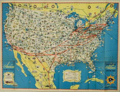
Sold20221940s American Airlines US Route Map -- American Airlines System MapTitle: 1940s American Airlines US Route Map -- American Airlines System Map Cartographer: American Airlines (General Drafting Co.) Year / Place: 1940s c. Map Dimension (in.): 24 X 32 in. Ths is an attSee Sold Price
Sold20231950s American Airlines Route Map -- American Airlines Route MapTitle: 1950s American Airlines Route Map -- American Airlines Route Map Cartographer: American Airlines Year / Place: 1950s Map Dimension (in.): 12.5 X 19.2 in. joined This nice, large pictorial routeSee Sold Price
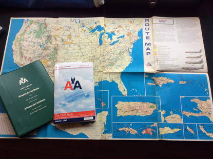
Sold2023Vintage American Airlines Route Map, American Airline Trip Book and BinderVintage American Airlines Route Map, American Airline Trip Book and BinderSee Sold Price
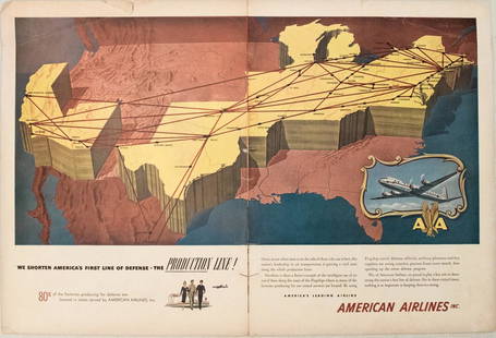
Sold20191949 American Airlines Route Map AdTitle/Content of Map: 1949 American Airlines Route Map Ad Date: 1949Cartographer: American Airlines Size: 13.6 X 21 in. when joined This is an attractive ad highlightingAmerican Airlines routes - servSee Sold Price
Sold20181940, 1941 American Airlines CalendarsTogether with 1939 Pennsylvania Railroad Calendar missing some months. Both American Airlines Calendars 12 months.See Sold Price
Sold20221947 New England Airport Map & Circa 60's American AirlinesSystem Map. New England Map has some tearing. Please see photos and come to the 2 day preview for condition.See Sold Price
Sold20181957 Route Map of Pan American Airline to Mexico,Title/Content of Map: 1957 Route Map of Pan American Airline to Mexico, Central America and Part of Caribbean -- Pan American Flight Map [to] Mexico & Central America Date: 1957 Cartographer: PanAm SiSee Sold Price
Sold20171950 Map of PanAm Airline Caribbean Routes1950 Map of PanAm Airline Caribbean Routes -- Pan American Flight Map New York and Caribbean. PanAm, 1950 ca., A nice folding map of Pan American Airline routes to Caribbean from New York City & MiamiSee Sold Price
Sold20211796 RARE Morse American ATLAS Geography MAPS Africa1796 RARE Morse American ATLAS Geography MAPS Africa France Asia Holy Land Jedidiah Morse was an important and prominent geographer known for his American textbooks, books that earned him the name fatSee Sold Price
Sold2018American Airlines System Maps Circa 1960's/70's?American Airlines System Maps Circa 1960's/70'sSee Sold Price
Sold20231810 American Gazetteer ATLAS Map Georgia Native Americans RARE Jedidiah Morse1810 American Gazetteer ATLAS Map Georgia Native Americans RARE Jedidiah Morse Jedidiah Morse was an important and prominent geographer known for his American textbooks, books that earned him the nameSee Sold Price
Sold20201798 American Gazetteer ATLAS Map Georgia Indians1798 American Gazetteer ATLAS Map Georgia Native Americans RARE Jedidiah Morse Jedidiah Morse was an important and prominent geographer known for his American textbooks, books that earned him the nameSee Sold Price
Sold2023PAN AMERICAN AIRLINES ROUTE MAP. "Fastest way between… USA & Latin America" 1935Title: PAN AMERICAN AIRLINES ROUTE MAP. "Fastest way between… USA & Latin America" 1935 Description: Consult this map for fastest way between all points in the United States and Latin America' bSee Sold Price
Sold2018American Airlines Route Map World's Fair Line 1939American Airlines Route Map World's Fair Line 1939See Sold Price
Sold2018American Airlines System Map 1952American Airlines System Map 1952, 33 1/2" x24"See Sold Price
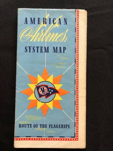
Sold2018American Airlines System Map Route Of The Flagships 194American Airlines System Map Route Of The Flagships 1946See Sold Price
Sold2018Two Large Maps of the WorldTwo Large Maps of the World, American Air Lines & Menier Chocolate. American Airlines Air World Map, showing the distances to various cities and locations from the geographical center of the United StSee Sold Price
Sold2021MITCHELL - New General Atlas [35 American maps] 1867MITCHELL, S. Augustus, Jr.. Mitchell's New General Atlas, containing maps of various countries of the world, plans of cities, etc., ... together with valuable statistical tables. Philadelphia: S. AuguSee Sold Price
Sold2020LOT OF 4 VINTAGE PHOTO / LIFESTYLE BOOKSLOT OF 4 VINTAGE PHOTO / LIFESTYLE BOOKS INCLUDING LIFE CLASSIC PHOTOGRAPHS, DE LOREAN, WE AMERICANS, PREMIER WORLD ATLAS MAPS -13" X 11" AVERAGE EACH -VERY GOOD VINTAGE CONDITION, SEE PHOTOSSee Sold Price
Sold2022Pan American Airlines Clipper Club Pilot's 1940's Map.Showing routes flown, framed, 19 x 33 inches.See Sold Price
Sold20231795 Carey's Am Ed of Guthries Impr Geography1795 Matthew Carey "Carey's American Edition of Guthrie's Geography Improved", 1st edition of the 1st American printed atlas, 43 of 44 maps remaining, incl Doolittle's Vermont, Virginia, the CarolinasSee Sold Price
BonhamsMORSE (SIDNEY E.) Morse's North American Atlas, New York, Harper & Brothers, 1842 [but 1845]£650
6 days LeftJasper52Océanique. Iles des Navigateurs #41 Samoa & American Samoa VANDERMAELEN 1827 mapUS$60
5 days LeftJasper521822 MAP of SOUTH AMERICA GEOGRAPHICAL STATISTICAL HISTORICAL antique 17.5x 22"US$75
5 days LeftJasper521822 MAP of LEEWARD ISLANDS GEOGRAPHICAL STATISTICAL HISTORICAL antique 17.5x22"US$120
15 hrs LeftDuMouchellesRigobert Bonne (French, 1727-1794) Hand Colored Engraving Ca. 18th Century, Les Etats Unis DeUS$50(1 bid)
7 days LeftThe Ross Art GroupOriginal American Airlines Travel to California Poster by Boyle c1960US$800(1 bid)
7 days LeftThe Ross Art GroupOriginal Vintage American Airlines Boston 1953 Poster by E.McKnight KaufferUS$450
7 days LeftThe Ross Art GroupOriginal American Airline Poster c1955 Washington DC by E McKnight KaufferUS$600
17 hrs LeftRapid Estate Liquidators and Auction GalleryScott Sanderson Signed American Airlines Golf LetterUS$50


![1957 Route Map of Pan American Airline to Mexico,: Title/Content of Map: 1957 Route Map of Pan American Airline to Mexico, Central America and Part of Caribbean -- Pan American Flight Map [to] Mexico & Central America Date: 1957 Cartographer: PanAm Si](https://p1.liveauctioneers.com/5584/124256/63192867_1_x.jpg?height=310&quality=70&version=1530636078)


![MITCHELL - New General Atlas [35 American maps] 1867: MITCHELL, S. Augustus, Jr.. Mitchell's New General Atlas, containing maps of various countries of the world, plans of cities, etc., ... together with valuable statistical tables. Philadelphia: S. Augu](https://p1.liveauctioneers.com/7533/208644/106251073_1_x.jpg?height=310&quality=70&version=1624641782)


![MORSE (SIDNEY E.) Morse's North American Atlas, New York, Harper & Brothers, 1842 [but 1845] (1 of 2)](https://p1.liveauctioneers.com/1043/319451/178359102_1_x.jpg?height=282&quality=70&version=1717776906)


