Sold2018Mitchell: County Map of Quebec/Montreal InsetCartographer: S. A. Mitchell Place/Date: Philadelphia / 1870 Size: 13 1/4" x 10 3/4" Condition: full color; light overall age toning The beautifully detailed and colored county map of Quebec from theSee Sold Price
Sold2019Samuel Augustus Mitchell (1790-1868), " County Map ofSamuel Augustus Mitchell (1790-1868), " County Map of California with an inset of San Francisco and the Settlements of Great Salt Lake Country, Utah," 1867, hand colored, H.-15 1/8 in., W.-12 1/2 in.See Sold Price
Sold2017Mitchell: County Map of Texas, 1862County Map of Texas, S. Augustus Mitchell, 1862. 10.75 x 13.375 inches. Steel engraved map, with hand colored wash and outlines. Inset map of Galveston Bay, and Vicinity. Colored by county and territoSee Sold Price
Sold2016Mitchell: County Map of Florida 1867Map: County Map of Florida Maker: Mitchell Size: 11 x 13.25 inches Counties in original wash color. Inset of Mobile, AL. No Reserve: This lot starts at $1 and has no reserve as a courtesy so that collSee Sold Price
Sold2019Samuel Augustus Mitchell (1790-1868), "County Map ofSamuel Augustus Mitchell (1790-1868), "County Map of Florida," 1867, Atlas, with an inset of Mobile, H.- 12 in., W.- 12 3/8 in.See Sold Price
Sold2019Samuel Augustus Mitchell (1790-1868), "County Map ofSamuel Augustus Mitchell (1790-1868), "County Map of the State of California, with an Inset of San Francisco Bvay and Vicinity," 1872, H.-23 1/4 in., W.- 15 1/4 in.See Sold Price
Sold2019Samuel Augustus Mitchell (1790-1868), " County Maps ofSamuel Augustus Mitchell (1790-1868), " County Maps of the States of Georgia and Alabama, " 1883, with insets of Atlanta and Savannah," 1866, hand colored, H.-15 1/4 in., W.- 22 3/4 in.See Sold Price
Sold20191876 Mitchell Map of Maine -- County Map of the StateTitle/Content of Map: 1876 Mitchell Map of Maine -- County Map of the State of Maine Date: 1876 Philadelphia Cartographer: S MitchellSize: 13.4 X 10.6 in. This is a very nice map of Maine with inset oSee Sold Price
Sold2021County map of FloridaTitle: County map of Florida Artist: S. Augustus Mitchell, Jr. Medium: Lithograph Dimensions: 10 1/2 x 13 1/4 Description: 1881 map of Florida, with inset of Mobile Reserve: $75.00 Shipping: DomeSee Sold Price
Sold2018County Map of Texas.Title/Content of Map: County Map of Texas. Date Printed: 1870 Cartographer: MITCHELL, SAMUEL AUGUSTUS (JR.) Material/Medium: S. Augustus Mitchell, Jr. Size: 9.25X12 Inset of Galveston Bay and VicinitySee Sold Price
Sold2018Mitchell: Antique Map of New York State w/ city insetsCounty Map of the State of New York The beautifully detailed and colored county map of New York State from the 1870 edition of Mitchell's popular New General Atlas of the world. Framed by the vine motSee Sold Price
Sold2018Mitchell: New York State with City InsetsMap Title: County Map of the State of New York Cartographer: S. A. Mitchell Place & Date: Philadelphia / 1870 Size: 21 1/8" x 13 3/4" Condition: full color; overall age toning; repaired split in lowerSee Sold Price
Sold2023Samuel Augustus Mitchell 'County Map of...GA and AL'A Samuel Augustus Mitchell (American, 1792-1868) hand colored engraving titled 'County Map of the States of Georgia and Alabama' depicting the tri-state area of Georgia, Alabama and part of Florida anSee Sold Price
Sold20171862 Mitchell county map of Minnesota in near fineGreat chance to own an actual 150-year-old piece of history for a reasonable price. Beautiful and clean county map of Minnesota from Mitchell’s 1866 New General Atlas. When matted and framed, antiquSee Sold Price
Sold2018Mitchell: County Map of Kentucky & Tennessee, 1870Title/Content of Map: County Map of Kentucky and Tennessee Cartographer: S. A. Mitchell Place & Date: Philadelphia / 1870 Size: 13 3/8" x 9 3/4" Condition: full color; light overall age toning; slightSee Sold Price
Sold2018Mitchell: County Map of Ohio and IndianaMap: County Map of Ohio and Indiana Cartographer: S. A. Mitchell Place/Date: Philadelphia / 1870 Size: 14" x 11 3/4" Condition: full color; light overall age toning The beautifully detailed and coloreSee Sold Price
Sold2018Mitchell: County Map of Iowa and MissouriMap: County Map of the States of Iowa and Missouri Cartographer: S. A. Mitchell Place/Date: Philadelphia / 1870 Size: 10 3/4" x 13 5/8" Condition: full color; light overall age toning The beautifullySee Sold Price
Sold2018Mitchell: County Map of PennsylvaniaReserve Reduced! The beautifully detailed and colored county map of Pennsylvania from the 1870 edition of Mitchell's popular New General Atlas of the world. The map is framed by the vine motif borderSee Sold Price
Sold2019Mitchell: County Map of Virginia and West VirginiaMap Title: County Map of Virginia and West Virginia Cartographer: S. A. Mitchell Place / Date: Philadelphia / 1870 Size: 14" x 11 5/8" Condition: full color; light overall age toning; tears and frayinSee Sold Price
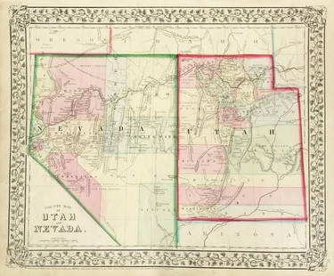
Sold2019Mitchell: County Map of Utah & NevadaMap Title: County Map of Utah and NevadaCartographer: S. A. Mitchell Place/Date: Philadelphia / 1870 Size: 14" x 11 5/8" Condition: full color; light overall age toning The beautifully detailed and coSee Sold Price
Sold2022English county maps.- Northern England.- Speed (John)NO RESERVE English county maps.- Northern England.- Speed (John) Anno Darbieshire described, county map, inset town plan of Derby and inset view of St Anne's well at Buxton, engraving, 385 x 510 mm (1See Sold Price
Sold2020Mitchell's County Map of the State of New York 1867Mitchell's County Map of the State of New York, 1867, S.Augustus Mitchell. Has some small tearing where the pages are joined but is in otherwise very good condition. Measures approx. 15" tall x 22" wiSee Sold Price
Sold2017Mitchell: Antique Map of Minnesota, 18621862 Mitchell county map of Minnesota in near fine condition. Great chance to own an actual 150-year-old piece of history for a reasonable price. Beautiful and clean county map of Minnesota from MitchSee Sold Price
Sold2017Mitchell: Antique County Map of Texas, 1873Excellent 1873 County Map of Texas by S. Augustus Mitchell. Impressive two-page County Map of the State of Texas. Map image much larger than earlier Mitchell maps. Designed and engraved by W. H. GamblSee Sold Price
6 days LeftJasper521860 Mitchell Map of Kentucky and Tennessee -- County Map of Kentucky and TennesseeUS$40
6 days LeftJasper521869 Mitchell Map of South-Central Europe [verso] Asia -- XXXIV Austria, Switzerland, Italy, TurkeyUS$30
6 days LeftJasper521869 Mitchell Map of Much of Western Europe -- XXXII Prussia the German States Holland & BelgiumUS$30
6 days LeftJasper521858 Mitchell Map of Great Britain and Ireland [verso] Germany and Switzerland -- No. 22 Map ofUS$25
6 days LeftJasper521858 Mitchell Map of Southern Europe and France [verso] Asia -- No. 24 Map of France, Spain,US$30
6 days LeftJasper521887 Cram Map of Texas [verso] Indian Territory [verso] Arkansas -- Texas [verso] Indian Ty. [verso]US$95
6 days LeftJasper521861 Mitchell Map of Washington DC -- Plan of the City of Washington The Capitol of the UnitedUS$70
7 days LeftJasper52EUROPE. General map. Inset table of population & density by country. SDUK 1844US$20
7 days LeftJasper52EUROPE. General map. Inset table of population & density by country . SDUK 1844US$20
Featured6 days LeftJasper52Mitchell’s Map of Asia showing travel routes London, India, China & Japan, 1860US$45
6 days LeftJasper521865 Johnson Map of Arkansas, Mississippi and Louisiana -- Johnson's Arkansas, Mississippi andUS$60
7 days LeftJasper52Russia in Europe, Sweden & Norway. Denmark Holland Belgium. MITCHELL 1869 mapUS$45
7 days LeftJasper52Austrian Empire, Italian States, Turkey in Europe & Greece. MITCHELL 1869 mapUS$55
7 days LeftJasper52CZECHOSLOVAKIA. w/ Carpathian Ruthenia. Prague/Praha. Bohemia Moravia 1920 mapUS$25
Featured7 days LeftJasper52MEDITERRANEAN PORTS. Marseille Gibraltar Valetta Naples Algiers Piraeus 1903 mapUS$30


![1869 Mitchell Map of South-Central Europe [verso] Asia -- XXXIV Austria, Switzerland, Italy, Turkey (1 of 2)](https://p1.liveauctioneers.com/5584/328338/176911683_1_x.jpg?height=282&quality=70&version=1715113718)


![1858 Mitchell Map of Great Britain and Ireland [verso] Germany and Switzerland -- No. 22 Map of (1 of 2)](https://p1.liveauctioneers.com/5584/328338/176911589_1_x.jpg?height=282&quality=70&version=1715113718)
![1858 Mitchell Map of Southern Europe and France [verso] Asia -- No. 24 Map of France, Spain, (1 of 2)](https://p1.liveauctioneers.com/5584/328338/176911601_1_x.jpg?height=282&quality=70&version=1715113718)
![1887 Cram Map of Texas [verso] Indian Territory [verso] Arkansas -- Texas [verso] Indian Ty. [verso] (1 of 3)](https://p1.liveauctioneers.com/5584/328338/176911685_1_x.jpg?height=282&quality=70&version=1715113718)


