Sold20241839. Ancient Germania and Central Europe by MoninTitle/Content: 1839. Ancient Germania and Central Europe by Monin Date: 1839 Medium: Hand colored, engraved Dimensions: 17 1/2" x 12 1/2" Description: Map of Ancient tribal Germany and Central Europe.See Sold Price
Sold2016Map of Ancient Germany by JanssonHeading: Author: Jansson, Jan Title: Germaniae Veteris, Typus Place Published: Amsterdam Publisher: Date Published: c.1640 Description: Copper-engraved map, hand-colored inSee Sold Price
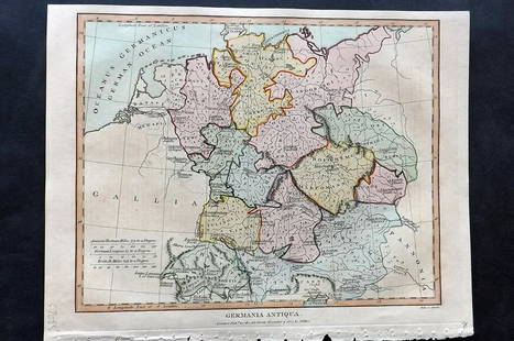
Sold2021Wilkes, John 1807 Hand Col Map. Ancient Germany"Germania Antiqua" Finely Hand Colored Copper Engraved Map Published 1796-1828 London for "Encyclopaedia Londinensis, or universal dictionary of arts, sciences and literature" by John Wilkes et al. PaSee Sold Price
Sold2021Dussieux, Louis 1859 Mixed Lot of 6 MapsIncl Europe, UK, France, French Empire, Ancient Britain/Germany and Persian Empire/Asia Minor. Steel Engraved Map Published 1859, Paris for "Atlas Complet de Geographie Elementaire" by Louis Dussieux.See Sold Price
Sold20241839 Germany and Central Europe by MoninTitle/Content: 1839 Germany and Central Europe by Monin Date: 1839 Medium: Hand colored, engraved Description: Map of Germany and all of Central Europe. Including the Austrian Empire. 1839. By V. MoniSee Sold Price
Sold2023Russell & Barclay 1838 Hand Col Map. Prussia. GermanyHand Colored Copper Engraved Map Published 1823-40, by Fisher & Son, "A Complete Atlas of the World" by John Russell et al. A Very Rare Work which is compiled from the same plates used in different edSee Sold Price
Sold20241839 Known Ancient World Map by MoninTitle: 1839 Known Ancient World Map by Monin Date/Period: 1839 Materials: Hand colored, engraved Size: 17 1/2 x 12 1/2" This map is a fascinating illustration of the world as known to the ancient GreeSee Sold Price
Sold20241839. Ancient France (Gaul) by MoninTitle: 1839. Ancient France (Gaul) by Monin Date/Period: 1839 Materials: Hand colored, engraved Size: 17 1/2” x 12 1/2” Map of Ancient France, GAUL. 1839. By V. Monin. Paris. Hand-colored,See Sold Price
Sold2015Map of Ancient Italy. Europe. 1835.Print of hand colored steel engraving titled Italie Ancienne“.Author C. V. Monin.Engraved by unknown.From the Atlas Universel de Geography“ by C. V. Monin. Parsi. 1835.Italy officially the ItalianSee Sold Price
Sold2016Map of known world of the ancients. 1835.Print of hand colored steel engraving titled „Monde connu des Anciens“.Author C. V. Monin.Engraved by unknown.From the „Atlas Universel de Geography“ by C. V. Monin. Parsi. 1835.See Sold Price
Sold202316th Century Soest Germany Colored Map Etching with information about town in German on revere16th Century Soest Germany Colored Map Etching with information about town in German on reverse. Measurements in inches: 20 1/4 x 16 Condition:Has tape residue on top edge, well toned, brittle pages aSee Sold Price
Sold2017Antique 19th C French Hand Colored Map of AriegeAntique 19th C French Hand Colored Map of Ariege. Hand colored well detailed engraving showing the French department of Ariege with scenes of regional trade, products and life along with a coat of armSee Sold Price
Sold2017Antique 19th C French Hand Colored Map of CalvadosAntique 19th C map of the French area of Calvados. This area of France is known for its production of Calvados. The engraving is surrounded by scenes showing the region and its products. Published bySee Sold Price
Sold2021French Hand-Colored Map of America, 1750Antique French Hand-Colored Map of America , "Amerique Septentrionale, dressee, sur les Relations les plus modernes...", 1750, Robert de Vaugondy, the cartouche with an alligator flanked by figures, 1See Sold Price
Sold2023Early Hand Colored Map French Region, approx. 26" X 33"Early Hand Colored Map French Region, approx. 26" X 33"See Sold Price
Sold2018Antique French Copper Engraved Colored Map, Amsterdam18th century antique French copper engraved and hand colored maps of Amsterdam, Netherlands titled "Lemouicum, Auctore Jo. Faiano M.L. - Lymosin [on sheet with] Topographia Limaniae, Auctore GabrieleSee Sold Price
Sold2020Three maps, late 18th-early 19th centuryThree mapslate 18th-early 19th centuryComprising a French hand-colored copperplate map of Virginia, 1760-1762; a map of the United States, 1719, by H.A. Chatelain, Amsterdam; and a map of Delaware, 18See Sold Price
Sold2017Map of the AmericasEarly Hand colored French map of the Americas. Site 20.5" x 24"See Sold Price
Sold2023Antique French Map Isle de Saint ChristopheAntique MDCCLVIII French Language Hand Colored Map of Isle de Saint Christophe (St. Kitts), Framed. 31 inches x 42 inchesSee Sold Price
Sold2020Antique Framed Hand Colored Large Map of GrenadaAntique Professionally Framed French Hand Colored Large Map of Grenada. Entitled Carte de L'Isle, de la Grenade. Double matted. 43 inches x 30 inchesSee Sold Price
Sold2022ANTIQUE FRENCH NORMANDY MAPS ENGRAVINGS 17TH CEN.A pair of antique French hand-colored engravings maps. The first is titled, Le Pais De Cavx Normandy Part of Picardy. The Pais or Pays de Caux is a natural region of Normandy belonging to the Paris BaSee Sold Price
Sold2017Janssonius: Map of Ancient Germany, 1645TITLE/CONTENT OF MAP: 'Germaniae Veteris Nova Descriptio [Ancient Germany newly described]' A map of ancient Germany, based on Ortelius' map, which was in turn based on the writings of Ptolemy, Pliny,See Sold Price
Sold2018Framed 18th C. French Map of Ancient Rome**First Time At Auction** Louis Brion de la Tour (French, 1743-1810) & Louis Charles Desnos (French, 1725-1805), "Suite De L'Histoire De Rome", ca. 1760 to 1770. Copperplate engraved with original hanSee Sold Price
Sold2022French Le Maine hand colored map engraving, central France, by Nicolas Sanson (1600-1667) 15"H xFrench Le Maine hand colored map engraving, central France, by Nicolas Sanson (1600-1667) 15"H x 19"W (image), 23"H x 30 3/4"W (frame)See Sold Price
5 days LeftTrillium Antique Prints & Rare BooksBraun & Hogenberg, pub. 1575 - View of Innsbruck, GermanyUS$100
2 days LeftJasper521890 c. Clemens Wooden Puzzle Map of the US -- Clemens' Silent Teacher Dissected Map of the UnitedUS$240
Featured3 days LeftJasper52PACIFIC OCEAN currents British French German US Spanish colonies. LETTS 1889 mapUS$15
May 19Chinwe Russell AuctionsFootpaths to the Copses #1 By David Davies Ink, charcoal, watercolour created with Ink, charcoal,US$350
May 14Fleischer's Auctions1755 Map Partie de l'Amerique Septentrionale, qui comprend Le Cours de L'Ohio...US$200(3 bids)
May 19Chinwe Russell AuctionsThe Gathering Charm By David Davies Ink, charcoal, watercolour created with Ink, charcoal,US$250
May 19Chinwe Russell AuctionsFootpaths By David Davies Ink, charcoal, watercolour created with Ink, charcoal, watercolour 2021US$300
2 days LeftDoyle New YorkVaugondy's map of Virginia and Maryland, a reduction of Fry and Jefferson's landmark mapUS$600
May 19Chinwe Russell AuctionsPathways to the Copses #4 By David Davies Ink, charcoal, watercolour created with Ink, charcoal,US$250
May 14Hermann Historica GmbHA French silver-gilt pill box, Paris, Paul Guillon (1899 - 1924), circa 1910€300


![Antique French Copper Engraved Colored Map, Amsterdam: 18th century antique French copper engraved and hand colored maps of Amsterdam, Netherlands titled "Lemouicum, Auctore Jo. Faiano M.L. - Lymosin [on sheet with] Topographia Limaniae, Auctore Gabriele](https://p1.liveauctioneers.com/6377/128239/65869733_1_x.jpg?height=310&quality=70&version=1540604375)


![Janssonius: Map of Ancient Germany, 1645: TITLE/CONTENT OF MAP: 'Germaniae Veteris Nova Descriptio [Ancient Germany newly described]' A map of ancient Germany, based on Ortelius' map, which was in turn based on the writings of Ptolemy, Pliny,](https://p1.liveauctioneers.com/5584/103242/52831744_1_x.jpg?height=310&quality=70&version=1493321322)


![[MAP - TOURS] (1 of 1)](https://p1.liveauctioneers.com/292/326828/175962850_1_x.jpg?height=282&quality=70&version=1713473479)


