Sold2023NAUTICAL CHART / CHESAPEAKE BAY COVE POINT TO SANDY POINTDescription: United States – East Coast Maryland. NAUTICAL CHART / CHESAPEAKE BAY COVE POINT TO SANDY POINT. Published at Washington D.C/ US Department of Commerce National Oceanic and AtmospheSee Sold Price
Sold2022Framed Maryland Chesapeake Bay Chart / MapNOAA Chart 12273, Maryland Chesapeake Bay Sandy Point to Susquehanna River. Professionally sealed in frame. Excellent condition. 41"x36.5".See Sold Price
Sold2023J ROBERT BURNELL "Off Sandy Point" Watercolor:J ROBERT BURNELL "Off Sandy Point" Watercolor: Sailing Sloop Rig Skipjack Fishing Boat with 1883 Sandy Point Lighthouse on the Chesapeake Bay. Listed VA Artist and Teacher with Over 6000 Works, 1929-2See Sold Price
Sold2023Chart from Penobscot Bay to KennebecNautical chart from Penobscot Bay to the Kennebec river on the coast of Maine. Showing St. Georges, Cushing, Waldoboro, Damariscotta Whitehead, Marshalls Point, Thomaston, Bath, Etc. A Navigator has pSee Sold Price
Sold2022Framed Chesapeake Bay MD/VA Nautical ChartFramed nautical chart / map of the Chesapeake Bay, between the Maryland and Virginia border. Map is in excellent condition Paper backing is torn on back of frame and lower right corner of frame has seSee Sold Price
Sold2016STAPLETON KEARNS (MA/ME/MN, 1952 - ) - "Sailing OffSTAPLETON KEARNS (MA/ME/MN, 1952 - ) - "Sailing Off Sandy Point", oil on canvas, signed lower left and dated 1999, titled verso on Bay View Gallery of Camdern, Maine label, in fatigued silver molded cSee Sold Price
Sold2023Louise Schneider (Virginia/NY 20th C.) WatercolorLouise Schneider ( Virginia / New York 20th Century ) Watercolor Mixed Media Oil Landscape Titled " Harbor Village " Depicts a Gorgeous Waterside Town View of Hempstead Bay Sand's Point Glen Cove SeaSee Sold Price
Sold2023Early German Dividing Caliper, 16th CenturyEarly German Dividing Caliper, 16th Century Compass with 2 points, wrought iron, length 11 in. - Used to mark out locations or on nautical chart to measure a distance between two points on a map. Fr&#See Sold Price
Sold2023Nautical Chart: SOUTHERN COAST OF LONG ISLAND SOUND/ MONTAUK POINT TO EAST HAMPTONDescription: SOUTHERN COAST OF LONG ISLAND SOUND/ FROM MONTAUK POINT TO EAST HAMPTON Measurement approximate: 32 x 22 InchesMaterial: PaperSee Sold Price
Sold2023NAUTICAL CHART/ CONNECTICUT NEW YORK. NORTH SHORE OF LONG ISLAND SOUND GREENWICH POINT TO NEWDescription: NAUTICAL CHART EAST COAST/ CONNECTICUT – NEW YORK. NORTH SHORE OF LONG ISLAND SOUND GREENWICH POINT TO NEW ROCHELLE. Published at Washington D.C/ JUNE 1939 (6TH Edition) First editSee Sold Price
Sold2023NAUTICAL CHART/ CONNECTICUT NEW YORK. NORTH SHORE OF LONG ISLAND SOUND GREENWICH POINT TO NEWDescription: NAUTICAL CHART EAST COAST/ CONNECTICUT – NEW YORK. NORTH SHORE OF LONG ISLAND SOUND GREENWICH POINT TO NEW ROCHELLE. Published at Washington D.C/ JUNE 1939 (6TH Edition) First editSee Sold Price
Sold2023NAUTICAL CHART CONNECTICUT NORTH SHOREOF LONG ISLAND SOUND STRATFORD TO SHERWOOD POINTDescription: NAUTICAL CHART CONNECTICUT NORTH SHOREOF LONG ISLAND SOUND STRATFORD TO SHERWOOD POINT. Published at Washington, D.C. U.S. Department of Commerce Environmental Science Services AdministraSee Sold Price
Sold2016Lot Of 3: Custom Fixed Blade Knives.1) Ray Beers fixed blade, 3-5/8", overall length of 7-1/8", with hard wood handle made for the "Chesapeake Bay Knife Club Inc", knife features a worked back and saber ground drop point blade, no sheatSee Sold Price
Sold2021N. Shore of the L.I. Sound, CT USCGN. Shore of the L.I. Sound, CT USCG, Coast Guard nautical chart of the L.I. Sound, Stratford to Sherwood Point, CT. C. & G. S. 220; published 1969. Approximate measurements: 35" x 43" (INCHES) MateriaSee Sold Price
Sold2021George Eldridge, Large Chart of Chesapeake Bay 1868George Eldridge / G. W. Boynton, Sc., ELDRIDGEÕS CHART OF CHESAPEAKE BAY, JAMES, YORK, RAPPAHANNOCK AND POTOMAC RIVERS. Compiled from the latest surveys by GEORGE ELDRIDGE, HYDROGRAPHER. Boston: S. TSee Sold Price
Sold2022Vintage RR map of Maryland & Delaware, 1850Excellent 1850 map of Maryland and Delaware with a chart of Chesapeake Bay Steamboat Routes. Published a decade before the Civil War and during an explosion in the country's railroad routes, the map aSee Sold Price
Sold20185 1/4" Sandy Hill Adena Point. Dorchester Co, MD.5 1/4" Sandy Hill Adena Point. Sandy Hill. Dorchester Co, MD. Hornstone, some damage to base. Ex-Earl Townsend, Collins B. Allen. Old tag reads (450?), p. 93)See Sold Price
Sold20186 3/8" Sandy Hill Adena Point. Dorchester Co, MD.6 3/8" Sandy Hill Adena Point. Sandy Hill. Dorchester Co, MD. Hornstone. Ex-Earl Townsend, Collins B. Allen. Old tag reads 467, p. 96 (indicating where pictured in Sandy Hill photos)See Sold Price
Sold2022Framed Corpus Christi Bay Nautical ChartCorpus Christi nautical chart, 4th ed., dated "May / 10" marked by the National Oceanic and Atmospheric Administration (NOAA), United States Coast and Geodetic Survey height 39 in. x width 49See Sold Price
Sold20211921 with 1943 Revision of Hiroshima Bay Nautical ChartTitle: 1921 with 1943 Revision of Hiroshima Bay Nautical Chart -- Japan Naikai or Inland Sea Aki Nada Hiroshima Wan Cartographer: US Hydrographic Office Year / Place: 1921 with 1943 Revision, WashingtSee Sold Price
Sold2020Rhode Map Narragansett Bay Nautical Chart MapRhode Map Narragansett Bay Nautical Chart Map. Used condition. 49 1/2" tall x 37" wide.See Sold Price
Sold2023Nautical Chart: FROM PENOBSCOT BAY TO KENNEBEC ENTRANCEDescription: FROM PENOBSCOT BAY TO KENNEBEC ENTRANCE Measurement approximate: 40 x 31 InchesMaterial: PaperSee Sold Price
Sold2020MORTIER, PIERRE. Carte Particuliere de Virginie,MORTIER, PIERRE. Carte Particuliere de Virginie, Maryland, Pennsilvanie, la Nouvelle Jarsey Orient et Occidentale. Large double-page engraved chart of the Chesapeake Bay. 25x37 inches sheet size, wideSee Sold Price
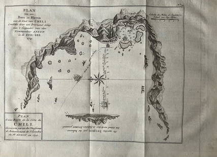
Sold2022Nautical chart of a unidentified bay in Chile. By the English pirate Anson 1749Title: Nautical chart of a unidentified bay in Chile. By the English pirate Anson 1749 Date/Period: 1749 Materials: Copper plate engraved Size: 13 1/2 x 9 3/4” Nautical chart of a unidentified BSee Sold Price
6 days LeftUkiyoe Gallery Japanese Woodblock PrintsHokusai Katsushika: The Kazusa Sea Route Woodblock NRUS$150
6 days LeftHeartland Artifact Auctions Inc5 7/8" Bi-Point Blade, Davis COA, found fall of 2014 in the Tennessee River, Basin Bay, Ex FrankUS$150(6 bids)
2 days LeftJasper52Watercolour Nautical Marine Cornwall Rocky Cliff Shoreline By A E Newling C1920US$1,000