Sold2023Nautical Chart: FROM PENOBSCOT BAY TO KENNEBEC ENTRANCEDescription: FROM PENOBSCOT BAY TO KENNEBEC ENTRANCE Measurement approximate: 40 x 31 InchesMaterial: PaperSee Sold Price
Sold2023Chart from Penobscot Bay to KennebecNautical chart from Penobscot Bay to the Kennebec river on the coast of Maine. Showing St. Georges, Cushing, Waldoboro, Damariscotta Whitehead, Marshalls Point, Thomaston, Bath, Etc. A Navigator has pSee Sold Price
Sold2021"GEO. W. ELDRIDGE'S CHART G PENOBSCOT BAY TO MACHIAS""GEO. W. ELDRIDGE'S CHART G PENOBSCOT BAY TO MACHIAS"Dated 190130.5” x 51” sight. Framed 34.75” x 57.75”.See Sold Price
Sold20161800's Chart Showing Penobscot Bay, MaineOriginal coastal survey from 1880 detailing Penobscot Bay from Belfast to Thomaston and as far east as Deer Isle. Mounted in a silver frame. Top of chart has minor loss. Overall Dimensions: 48" H x 40See Sold Price
Sold2023NAUTICAL CHART / CHESAPEAKE BAY COVE POINT TO SANDY POINTDescription: United States – East Coast Maryland. NAUTICAL CHART / CHESAPEAKE BAY COVE POINT TO SANDY POINT. Published at Washington D.C/ US Department of Commerce National Oceanic and AtmospheSee Sold Price
Sold2022Framed Corpus Christi Bay Nautical ChartCorpus Christi nautical chart, 4th ed., dated "May / 10" marked by the National Oceanic and Atmospheric Administration (NOAA), United States Coast and Geodetic Survey height 39 in. x width 49See Sold Price
Sold20211921 with 1943 Revision of Hiroshima Bay Nautical ChartTitle: 1921 with 1943 Revision of Hiroshima Bay Nautical Chart -- Japan Naikai or Inland Sea Aki Nada Hiroshima Wan Cartographer: US Hydrographic Office Year / Place: 1921 with 1943 Revision, WashingtSee Sold Price
Sold2020Rhode Map Narragansett Bay Nautical Chart MapRhode Map Narragansett Bay Nautical Chart Map. Used condition. 49 1/2" tall x 37" wide.See Sold Price
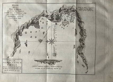
Sold2022Nautical chart of a unidentified bay in Chile. By the English pirate Anson 1749Title: Nautical chart of a unidentified bay in Chile. By the English pirate Anson 1749 Date/Period: 1749 Materials: Copper plate engraved Size: 13 1/2 x 9 3/4” Nautical chart of a unidentified BSee Sold Price
Sold2022Framed Chesapeake Bay MD/VA Nautical ChartFramed nautical chart / map of the Chesapeake Bay, between the Maryland and Virginia border. Map is in excellent condition Paper backing is torn on back of frame and lower right corner of frame has seSee Sold Price
Sold2023NAUTICAL CHART/ INLAND WATERS SHINNECOCK BAYTO GREAT SOUTH BAYDescription: NAUTICAL CHART/ INLAND WATERS SHINNECOCK BAYTO GREAT SOUTH BAY. United states – East Cost New York South Cost of Long Island. Published at Washington D.C June 1958 (11th Edition) FSee Sold Price
Sold2019Land Ho! Antique Narragansett Bay, RI and MA U.S. CoastDescription: Ahoy! Antique Coast Guard nautical chart of the Narragansett Bay. Numbered C. & G. S. 353; with corrections from the Coast Guard denoted in purple. Material: paper. Measurement: approximaSee Sold Price
Sold2021Oyster and Huntington Bays, NY USCGOyster and Huntington Bays, NY USCG, U.S. Coast Guard nautical chart of Oyster and Huntington Bays, S. Shore of LI Sound. Numbered C. & G. S. 224; published 1958.Approximate measurements: 36" x 41" (ISee Sold Price
Sold2021Oyster and Huntington Bays, NY USCGOyster and Huntington Bays, NY USCG, U.S. Coast Guard nautical chart of Oyster and Huntington Bays, S. Shore of LI Sound. C. & G. S. 224; published 1959. Approximate measurements: 36" x 41" (INCHES).See Sold Price
Sold2017Nautical Chart and Coastal Map of Monterey Bay, 1852Map: 1852 Nautical Chart and Coastal Map of Monterey Bay, California -- Monterey Harbor, CA from a Trigonometrical Survey Cartographer: US Coast Survey Year / Place: 1852 Map Dimensions: 13.1 x 11.7 iSee Sold Price
Sold2023NAUTICAL CHART/ UNITED STATES EAST COST DELAWARE BAY #2Description: NAUTICAL CHART/ UNITED STATES – EAST COST – NEW JERSEY DELAWARE / DELAWARE BAY. Published at Washington D.C June 1958 (11th Edition) First Edition 1916. / US Department of CSee Sold Price
Sold2023NAUTICAL CHART/ UNITED STATES EAST COST DELAWARE BAYDescription: NAUTICAL CHART/ UNITED STATES – EAST COST – NEW JERSEY DELAWARE / DELAWARE BAY. Published at Washington D.C June 1958 (11th Edition) First Edition 1916. / US Department of CSee Sold Price
Sold2020Nautical Map / Sea Chart, #224 Oyster & Huntington BaysUnited States East Coast, New York, Oyster & Huntington Bays, South Shore of Long Island Sound, 3rd edition feb 1/43; revised 7/21/58, note heavier bond paper and or better preserved than most; FoldedSee Sold Price
Sold2020Framed Navigational Chart Water Locations MaineFramed Navigational Chart #103 Water Locations in Maine. Penobscot Bay, Camden, and Rockport Maine. Burled wood frame. 44 inches x 31 inchesSee Sold Price
Sold2023NAUTICAL CHART EAST COAT NY/ OYSTER AND HUNTINGTON BAYS SOUTH SHORE OF LONG ISLAND SOUND. PublishedDescription: NAUTICAL CHART EAST COAT NY/ OYSTER AND HUNTINGTON BAYS SOUTH SHORE OF LONG ISLAND SOUND. Published at Washington, D.C. U.S. Department of Commerce Environmental Science Services AdministSee Sold Price
Sold2023NAUTICAL CHART EAST COAT NY/ OYSTER AND HUNTINGTON BAYS SOUTH SHORE OF LONG ISLAND SOUND. #2Description: NAUTICAL CHART EAST COAT NY/ OYSTER AND HUNTINGTON BAYS SOUTH SHORE OF LONG ISLAND SOUND. Published at Washington, D.C. U.S. Department of Commerce Environmental Science Services AdministSee Sold Price
Sold20231914 Maritime Chart Of New York HarborUS Coast Survey Chart dated 1914. This is a nautical anchorage chart of New York Harbor, upper bay and narrows. This particular chart has areas marked where vessels were allowed to anchor in the bustlSee Sold Price
Sold2021N. Shore of the L.I. Sound, CT USCGN. Shore of the L.I. Sound, CT USCG, Coast Guard nautical chart of the L.I. Sound CT, Niantic Bay and Vicinity. C. & G. S. 214; Approximate measurements: 30" x 33" (INCHES) Materials: PaperShipping coSee Sold Price
Sold2021Eight Framed New England Nautical Charts.Largest frame 49 x 36 inches. This item is not eligible for in house shipping. Buyer will be responsible for arranging pickup or delivery.See Sold Price
2 hrs LeftJasper521794 de la Rochette Map of the English Channel and Bay of Biscay -- A Chart of the British ChannelUS$240
2 days LeftThe Rug LifeORIGINAL FITZ HUGH LANE (1804-1865) NATIONAL GALLERY OF ART EXHIBITION POSTER, 34IN x 42IN (86cm xUS$400
Jun 05Jasper52West coast of Africa from Cape Blanco… Arguin bay, Mauritania. LABAT 1745 mapUS$20
4 days LeftMichael's GalleryRalph Baker (Impressionist - Coastal Seacape) Signed Original WatercolorUS$500
Jun 08Leon GalleryPhilippe de Pretot, Etienne Andre (c. 1710 - 1787) and William Walton - Carte de Canal des Isles₱30,000
2 days LeftCutler Bay AuctionsCarroll Thayer Berry (1886 - 1978) "Coaster Before the Wind"US$100(2 bids)