Sold2021Nolan, Edward C1880 Map of The East India IslandsSteel Engraved Map Published C1880, London for "The Illustrated History of the British Empire in India and the East" by Edward H. Nolan. Centre fold as issued. Paper Size: 12 x 10 inch (30 x 25cm) GooSee Sold Price
Sold2019Japan C1880 Pair of Maps by Nolan & Blackie"The Islands of Japan with Corea..." Steel Engraved Map Published C1880, London for "The Illustrated History of the British Empire in India and the East" by Edward H. Nolan. Centre fold as published.See Sold Price
Sold2019Nolan, Edward C1880 Map of The Eastern HemisphereSteel Engraved Map Published C1880, London for "The Illustrated History of the British Empire in India and the East" by Edward H. Nolan. Centre fold as published. Paper Size: 12.5 x 9.5 inch (32 x 24cSee Sold Price
Sold2021Nolan, Edward C1880 Map of Eastern HemisphereSteel Engraved Map Published C1880, London for "The Illustrated History of the British Empire in India and the East" by Edward H. Nolan. Centre fold as issued. Paper Size: 12 x 10 inch (30 x 25cm) SmaSee Sold Price
Sold2021Nolan, Edward C1880 Decorative Map of IndiaSteel Engraved Map Published C1880, London for "The Illustrated History of the British Empire in India and the East" by Edward H. Nolan. Centre fold as issued. Paper Size: 12 x 10 inch (30 x 25cm) GooSee Sold Price
Sold2021Nolan, Edward C1880 Lot of 3 Maps. China, Japan, AsiaSteel Engraved Map Published C1880, London for "The Illustrated History of the British Empire in India and the East" by Edward H. Nolan. Centre fold as issued. Paper Size: 12 x 10 inch (30 x 25cm) GooSee Sold Price
Sold2023Nolan & Hughes C1880 Antique Map. Eastern HemisphereLithograph Map Published C1880, London for "The Illustrated History of the British Empire in India and the East" by Edward H. Nolan. Centre fold as issued. Drawn by W. Hughes. Paper Size: 12 x 10 inchSee Sold Price
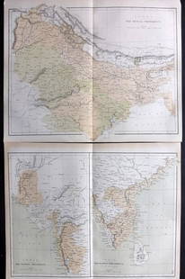
Sold2021Nolan, Edward C1880 Pair of Maps of India"India. The Bombay Presidency/India. The Madras Presidency" and "India The Bengal Presidency" Steel Engraved Map Published C1880, London for "The Illustrated History of the British Empire in India andSee Sold Price
Sold2019Nolan, Edward C1880 Lot of 6 Prints of IndiaSteel Engravings Published C1880, London for "The Illustrated History of the British Empire in India and the East" by Edward H. Nolan. Centre fold as published. Paper Size: 10 x 5 inch (25 x 16cm) VerSee Sold Price
Sold2021Nolan, Edward C1880 Lot of 8 India Related PortraitsSteel Engraving Published C1880, London for "The Illustrated History of the British Empire in India and the East" by Edward H. Nolan. Paper Size: 10 x 7 inch (25 x 18cm) Good Condition overallSee Sold Price
Sold2021Nolan, Edward C1880 Lot of 8 India Related PortraitsSteel Engraving Published C1880, London for "The Illustrated History of the British Empire in India and the East" by Edward H. Nolan. Paper Size: 10 x 7 inch (25 x 18cm) Good Condition overallSee Sold Price
Sold2023Nolan, Edward C1880 Lot of 9 Views & Scenes of IndiaSteel Engraving Published C1880, London for "The Illustrated History of the British Empire in India and the East" by Edward H. Nolan. Paper Size: 10 x 7 inch (25 x 18cm) Some toning in parts. Good ConSee Sold Price
Sold2023Nolan, Edward C1880 Lot of 6 India Prints. Battles, ScenesSteel Engraving Published C1880, London for "The Illustrated History of the British Empire in India and the East" by Edward H. Nolan. Paper Size: 10 x 7 inch (25 x 18cm) A couple of minor faults. GoodSee Sold Price
Sold2023Nolan, Edward C1880 Lot of 4 Views of IndiaSteel Engraving Published C1880, London for "The Illustrated History of the British Empire in India and the East" by Edward H. Nolan. Paper Size: 10 x 7 inch (25 x 18cm) A couple of minor faults. GoodSee Sold Price
Sold2023Nolan, Edward C1880 Lot of 6 India Related PortraitsSteel Engraving Published C1880, London for "The Illustrated History of the British Empire in India and the East" by Edward H. Nolan. Paper Size: 10 x 7 inch (25 x 18cm) Minor toning in parts, OtherwiSee Sold Price
Sold2023Nolan, Edward C1880 Lot of 4 Views of IndiaSteel Engraving Published C1880, London for "The Illustrated History of the British Empire in India and the East" by Edward H. Nolan. Paper Size: 10 x 7 inch (25 x 18cm) A couple of minor faults. GoodSee Sold Price
Sold2023Nolan, Edward C1880 Lot of 6 India Related PortraitsSteel Engraving Published C1880, London for "The Illustrated History of the British Empire in India and the East" by Edward H. Nolan. Paper Size: 10 x 7 inch (25 x 18cm) Good Condition overallSee Sold Price
Sold2023Nolan, Edward C1880 Lot of 6 India Related PortraitsSteel Engraving Published C1880, London for "The Illustrated History of the British Empire in India and the East" by Edward H. Nolan. Paper Size: 10 x 7 inch (25 x 18cm) Good Condition overallSee Sold Price
Sold2021India C1880 Lot of 22 Views & Military Prints by NolanIncl Delhi. Steel Engraving Published C1880, London for "The Illustrated History of the British Empire in India and the East" by Edward H. Nolan. Paper Size: 10 x 7 inch (25 x 18cm) Minor toning in paSee Sold Price
Sold2021India C1880 Lot of 4 Views & Military Prints by NolanIncl Delhi. Steel Engraving Published C1880, London for "The Illustrated History of the British Empire in India and the East" by Edward H. Nolan. Paper Size: 10 x 7 inch (25 x 18cm) Good ConditionSee Sold Price
Sold2019India 1860-C1880 Lot of 6 Prints by Nolan & GardnerSteel Engravings Published C1880, London for "The Illustrated History of the British Empire in India and the East" by Edward H. Nolan and Steel Engraving Published 1858-60 by Fullarton & Co, London &See Sold Price
Sold20231766 Emanuel Bowen Map East India IslandsEmanuel Bowen (1693-1767), "A New and Accurate Map of the East India Islands Laid down according to the latest discoveries and agreeable to the most approved Maps & Charts, The whole being regulated bSee Sold Price
Sold20201766 Emanuel Bowen Map East India IslandsEmanuel Bowen (1693-1767), "A New and Accurate Map of the East India Islands Laid down according to the latest discoveries and agreeable to the most approved Maps & Charts, The whole being regulated bSee Sold Price
Sold2023Lizars, Daniel 1831 LG Rare HC Map. East India Islands. Philippines Indonesia BorneoLarge Folio Copper Engraved Map Published 1831-2 by John Hamilton, Successor to Daniel Lizars, Edinburgh for "The Edinburgh Geographical and Historical Atlas..." First Edition by Daniel Lizars. Very fSee Sold Price
5 days LeftTrillium Antique Prints & Rare BooksPrevost - Pair of Engravings of Indian Coast and OceanUS$50
2 days LeftJasper521894 Johnston Map of Oceania [verso] Island in the Indian Ocean and Near Africa -- Oceania [verso]US$40
Jun 07Freeman's | Hindman[ENGLISH & CONTINENTAL MANUSCRIPTS]. EDWARD VIII, Duke of Windsor. Autograph letter letter signed toUS$250
5 days LeftTrillium Antique Prints & Rare BooksPrevost - Map of China, Korea, Japan, Phlippines and Surrounding IslandsUS$50
2 days LeftJasper521650 Jansson Map of the Elbe by Hamburg -- Nobilis Fluvius Albis maximb curb, ex variis, famosiqUS$110
3 days LeftBonhamsJULIO GONZÁLEZ (1876-1942) Étude pour l'homme cactus 14 3/4 x 10 5/16 in (37.5 x 26.2 ...US$12,000
5 days LeftTrillium Antique Prints & Rare BooksForbes - Red, Blue, and White Lotus, of HindostanUS$75
5 days LeftTrillium Antique Prints & Rare BooksForbes - Pair of Engravings of Fragrant Screw Pine (Pandanus odoratissimus) The Fruit of the KeuraUS$75
2 days LeftJasper521896 STANFORD'S COMPEDIUM of GEOGRAPHY & TRAVEL ASIA 2 VOLS. antique ILLUSTRATEDUS$220
5 days LeftTrillium Antique Prints & Rare BooksPrevost - Pair of Engravings of Chinese Boats or JunksUS$50
5 days LeftTrillium Antique Prints & Rare BooksPrevost - Chart of the Atlantic Ocean (Ocean Occidental, including parts of the Americas, Africa,US$50
6 days LeftMorean AuctionsAlleys East India Stock Ale Pre-Prohibition Serving Tray ULTRA RAREUS$175(3 bids)


![1894 Johnston Map of Oceania [verso] Island in the Indian Ocean and Near Africa -- Oceania [verso] (1 of 2)](https://p1.liveauctioneers.com/5584/328338/176911535_1_x.jpg?height=282&quality=70&version=1715113718)

![[ENGLISH & CONTINENTAL MANUSCRIPTS]. EDWARD VIII, Duke of Windsor. Autograph letter letter signed to (1 of 2)](https://p1.liveauctioneers.com/197/329395/177650345_1_x.jpg?height=282&quality=70&version=1715364962)


