Sold2020RAND, MCNALLY & CO.'s INDEXED ATLAS of the WORLDPublication Date: 1884 Title: RAND, MCNALLY & CO.'s INDEXED ATLAS of the WORLD Primary Authors: RAND, MCNALLY & CO Publisher: RAND, MCNALLY & CO containing large scale maps of every country and civilSee Sold Price
Sold20231888-9 RAND McNALLY & CO. INDEXED ATLAS OF THE WORLD maps ANTIQUE FOLIORand, McNally & Co.’s new indexed ATLAS OF THE WORLD Chicago; 1888-89 Massive folio. Size 11 by 14.5" Binding is worn with some damages, covers are detached, spine destroyed. Good interior, someSee Sold Price
Sold2023Rand McNally & Co. Indexed Atlas of the WorldIllinois,1881 "Rand, McNally & Co.'s Indexed Atlas of the World Historical and Descriptive" by Rand, McNally & Co. in 1881. Print on paper,15 1/2" x 12". From the collection of a Seekonk, MassachusettSee Sold Price
Sold2018Rand, McNally & Co.'s Indexed Atlas of the World Map ofTitle/Content of Map: Rand, McNally & Co.'s Indexed Atlas of the World Map of New York City Date: 1892 Cartographer: RAND, MCNALLY & CO. Size: 26X19 Pages 62-63 in Rand, McNally & Co.'s Indexed atlasSee Sold Price
Sold2019West Indies Rand, McNally & Co.'S Indexed Atlas Map ofTitle/Content of Map: West Indies Rand, McNally & Co.'S Indexed Atlas Map of the World Map of the West Indies. Date: 1898 Cartographer: RAND, MCNALLY & CO. Publisher: RAND, MCNALLY & CO. Size: 12.3HeiSee Sold Price
Sold2019Rand, McNally & Co.'S Indexed Atlas of the World.Reserve Reduced! Title: Rand, McNally & Co.'S Indexed Atlas of the World. Washington Publication Date: 1888 Cartographer: RAND, MCNALLY & CO. Publisher: RAND, MCNALLY & CO. Size (inches): H19 - W26 MaSee Sold Price
Sold2019Rand, McNally & Co.'S Indexed Atlas of the World.Reserve Reduced! Title: Rand, McNally & Co.'S Indexed Atlas of the World. Oregon Publication Date: 1888 Cartographer: RAND, MCNALLY & CO. Publisher: RAND, MCNALLY & CO. Size (inches): H19 - W26 Map shSee Sold Price
Sold2018Rand, McNally & Co.'S Indexed Atlas of the World Map ofReserve Reduced! Title/Content of Map: Rand, McNally & Co.'S Indexed Atlas of the World Map of Japan.Date: 1892 Cartographer: RAND, MCNALLY & CO. Material/Medium: RAND, MCNALLY & CO. Size: 19 x 25.8 iSee Sold Price
Sold2018Rand, McNally & Co.'S Indexed Atlas of the World Map ofTitle/Content of Map: Rand, McNally & Co.'S Indexed Atlas of the World Map of Philadelphia. Date: 1892 Cartographer: RAND, MCNALLY & CO. Size: 19X25.75 Pages 62-63 in Rand, McNally & Co.'s Indexed atlSee Sold Price
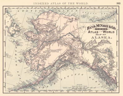
Sold2024Rand, McNally & Co.'S Indexed Atlas of the World Map of AlaskaTitle:Rand, McNally & Co.'S Indexed Atlas of the World Map of Alaska Publication Date: 1892 Cartographer:RAND, MCNALLY & CO. Publisher: RAND, MCNALLY & CO. Height: 9.3 Width: 11.8 Map showing AK withSee Sold Price
Sold2021Rand, McNally & Co.'S New Business Atlas Map ofPublication Date: c1892 Title: Rand, McNally & Co.'S New Business Atlas Map of Chicago. Rand. Mcnally & Co.'S Indexed Atlas of the World Railway Terminal Map Of Chicago. Cartographer: RAND, MCNALLY &See Sold Price
Sold2017Rand McNally: Antique Atlas Map of Asia, 1892Map: Rand, McNally & Co.'S Indexed Atlas of the World Map of Asia Publication Date: 1892 Authors: RAND, MCNALLY & CO., RAND, MCNALLY & CO. Publisher: RAND, MCNALLY & CO. Size: Folio – 19.00 H x 25.8See Sold Price
Sold2017Rand McNally: Indexed Atlas of the World Map of EuropeMap: Rand, McNally & Co.'S Indexed Atlas of the World Map of Europe. Publication Date: 1892 Authors: RAND, MCNALLY & CO., RAND, MCNALLY & CO. Publisher: RAND, MCNALLY & CO. Size: Folio – 19.00 H x 2See Sold Price
Sold2018Rand McNally: Antique Map of Europe, 1898Title/Content of Map: Europe Rand, McNally & Co.'S Indexed Atlas of the World Map of Europe. Date Printed: 1898 ca. Cartographer: RAND, MCNALLY & CO. Publisher: RAND, MCNALLY & COMPANY 1898 ca. CHICAGSee Sold Price
Sold2022Wyoming Rand, McNally & Co.'S New Indexed Atlas of the World. [Wyoming]Publication Date: 1888 Title: Wyoming Rand, McNally & Co.'S New Indexed Atlas of the World. [Wyoming] Cartographer: RAND, MCNALLY & CO. Publisher: RAND, MCNALLY & CO. | THE CONTINENTAL PUBLISHING CO.See Sold Price
Sold2016Map of California, 1899By Rand, McNally & Co., from Indexed Atlas Of The World. Chicago: 1899. Map features vignettes of Los Angeles, San Bernadino, Orange & San Diego Counties and seperate vignette of San Francisco area. DSee Sold Price
Sold2017Rand, McNally & Co: Map of North Dakota, 1898Map of North Dakota. Rand, McNally & Co. 1898 New Standard Atlas of the World, 21.5 x 15 inches Please note that this lot has a confidential reserve. When you leave a bid in advance of the auction, suSee Sold Price
Sold2016Rand, McNally & Co. Indexed State and Railroad Map ofRand, McNally & Co. Indexed State and Railroad Map of Mexico. Chicago - New York, 1892. Folded map. Atlas of the World Map of MexicoSee Sold Price
Sold2023Rand-McNally Indexed Atlas. New MexicoDescriptionTitle: Rand-McNally Indexed Atlas. New MexicoPublication Date: 1906Cartographer: RAND-MCNALLY & CO.Publisher: RAND-MCNALLY & CO.Height: 19Width: 12.5Page 264 from the Rand-McNally Indexed aSee Sold Price
Sold2020Indexed Atlas of the World OregonTitle: Indexed Atlas of the World Oregon Publication Date: 1898 Cartographer: RAND, MCNALLY & CO. Publisher: RAND, MCNALLY & CO. Brief Descriptions: Map detailed with counties separately colored, townSee Sold Price
Sold2020Colorado Indexed AtlasTitle: Colorado Indexed Atlas Date: 1911 Cartographer: RAND, MCNALLY & CO. Publisher: RAND, MCNALLY & CO. Size: 19Height - 25.5Width Map showing counties (separately colored), towns, topo., railroadsSee Sold Price
Sold2024Rand-McNally Indexed Atlas. Dominion of Canada And NewfoundlandTitle: Rand-McNally Indexed Atlas. Dominion of Canada And Newfoundland Publication Date: c1904 Cartographer: RAND, MCNALLY & CO. Publisher: RAND, MCNALLY & CO. Height: 19 Width: 26 From: Rand, McNallySee Sold Price
Sold2018Rand-McNally Indexed Atlas. Philippine IslandsTitle/Content of Map: Rand-McNally Indexed Atlas. Philippine Islands Date: 1904 ca. Cartographer: RAND, MCNALLY & CO. Size: 26 X 19 Page xxii, xxiii from Rand, McNally & Co.'s Enlarged business atlasSee Sold Price
Sold2020Rand McNally Index Atlas of the World Vol 1 1902Rand McNally Indexed Atlas of the World Historical - Descriptive - Statistical Volume I - United States, Rand McNally & Co, Chicago, 1902. Color engraved atlas of the United States.See Sold Price
4 days LeftJasper52Rand, McNally & Co.'S Indexed Atlas of the World Map of Germany (Western Sheet). | (Eastern Sheet).US$60
4 days LeftJasper52Austria-Hungary Rand, McNally & Co.'S Indexed Atlas of the World Map of Austria-Hungary.US$70
4 days LeftJasper52Rand, McNally & Co.'S Indexed County & Railroad Pocket Map And Shippers' Guide of KentuckyUS$80
4 days LeftJasper521894 Rand McNally Map of British Columbia -- Indexed Atlas of the World Map of British ColumbiaUS$35
2 days LeftHolabird Western Americana CollectionsPennsylvania RR Ephemera Early 1900s (3) [186857]US$10


![Wyoming Rand, McNally & Co.'S New Indexed Atlas of the World. [Wyoming]: Publication Date: 1888 Title: Wyoming Rand, McNally & Co.'S New Indexed Atlas of the World. [Wyoming] Cartographer: RAND, MCNALLY & CO. Publisher: RAND, MCNALLY & CO. | THE CONTINENTAL PUBLISHING CO.](https://p1.liveauctioneers.com/5584/256448/133385077_1_x.jpg?height=310&quality=70&version=1659478647)


![Rand-Mcnally Indexed Atlas. [Georgia.] (1 of 1)](https://p1.liveauctioneers.com/5584/343693/186665708_1_x.jpg?height=282&quality=70&version=1726603887)


![[MAPS] DOUBLE-PAGE. LOT OF 4 SOLD TOGETHER (1 of 4)](https://p1.liveauctioneers.com/8124/343618/186530168_1_x.jpg?height=282&quality=70&version=1726178725)
![[MAPS] MISC CANADA/AMERICA. LOT OF 6 (1 of 6)](https://p1.liveauctioneers.com/8124/343618/186530170_1_x.jpg?height=282&quality=70&version=1726178725)


![Pennsylvania RR Ephemera Early 1900s (3) [186857] (1 of 5)](https://p1.liveauctioneers.com/2699/343231/186247661_1_x.jpg?height=282&quality=70&version=1725927388)