Sold20181851 Tallis Map of North Africa -- Northern AfricaTitle/Content of Map: 1851 Tallis Map of North Africa -- Northern Africa Date: 1851, London Cartographer: J Tallis Size: 10 x 12.4 in. A very nice map of North Africa, including Tunisia, Algeria and MSee Sold Price
Sold2024MAGHREB. North Africa Morocco Algeria & Tunisia. JOHNSTON 1913 old antique mapTitle: MAGHREB. North Africa Morocco Algeria & Tunisia. JOHNSTON 1913 old antique map Description: N.W. Africa Comprising Morocco, Algeria & Tunis' by W. & A.K. Johnston, Limited, Edinburgh & London (See Sold Price
Sold2024NORTH AFRICA. Morocco Algeria Tunis Tunisia Egypt. Cairo. BARTHOLOMEW 1901 mapTITLE/CONTENT OF MAP: 'Morocco, Algeria, & Tunis; Upper & Lower Egypt; Inset map of Cairo' DATE PRINTED: 1901 IMAGE SIZE: Approx 33.5 x 44.0cm, 13.25 x 17.25 inches (Large); Please note that this is aSee Sold Price
Sold2023NORTH AFRICA. Morocco Algeria Tunis Tunisia Egypt. Cairo. BARTHOLOMEW 1901 mapTITLE/CONTENT OF MAP: 'Morocco, Algeria, & Tunis; Upper & Lower Egypt; Inset map of Cairo' DATE PRINTED: 1901 IMAGE SIZE: Approx 33.5 x 44.0cm, 13.25 x 17.25 inches (Large); Please note that this is aSee Sold Price
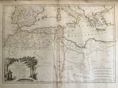
Sold20241837. Map of Barbary Coast. Northwest Africa. Morocco, Algeria, Libya and Tunisia. By A. PerrotTitle: 1837. Map of Barbary Coast. Northwest Africa. Morocco, Algeria, Libya and Tunisia. By A. Perrot Date/Period: 1837 Materials: Hand-colored steel engraving Size: 7 x 10 3/4” This is a map oSee Sold Price
Sold20231892 Black Map of Africa [on Separate Sheet] Morocco, Algeria to Tunisia [on Separate Sheet] EgyptTitle: 1892 Black Map of Africa [on Separate Sheet] Morocco, Algeria to Tunisia [on Separate Sheet] Egypt Cartographer: A&C Black Year / Place: 1892, Edinburgh Map Dimension (in.): 21.3 X 16.8 in. LarSee Sold Price
Sold2020Barbary coat. North west Africa. Morocco, Tunisia,Title: Barbary coat. North west Africa. Morocco, Tunisia, Algeria and Libya.. Date/Period: 1762 - 1771 Materials: Copperplate engraved Size: 20”x 14 1/2”. Barbary coast, shows North African countrSee Sold Price
Sold20211840 SDUK Map of Morocco -- Northern Africa or BarbaryTitle: 1840 SDUK Map of Morocco -- Northern Africa or Barbary I Marocco Cartographer: SDUK Year / Place: 1840, London Map Dimension (in.): 12.6 x 15.4 in This is very nice and superbly detailed map ofSee Sold Price
Sold20221851 Tallis Map of North Africa -- Northern AfricaTitle: 1851 Tallis Map of North Africa -- Northern Africa Cartographer: J Tallis Year / Place: 1851, London Map Dimension (in.): 10 x 12.5 in. Thisd is a very nice map of North Africa, including TunisSee Sold Price
Sold2020d'Urville, Dumont 1839 Lot of 6 Prints. North AfricaIncl Morocco, Algeria and Tunisia. Etchings Published 1834 by Chez Furne et Ce, Paris for "Voyage pittoresque autour du Monde - Résumé général des voyages de découvertes..." By Jules Dumont d'UrvSee Sold Price
Sold2023MAP, Africa, MercatorNorthwestern Africa. Mercator/Hondius, Fessae Regnum, from Atlas Minor, 1609 (published). Hand Color. This charming small map of Morocco and Algeria extends south to Beninia and Nussini and includes tSee Sold Price
Sold2021North Africa Nations Stamp CollectionNorth Africa Nations stamp collection. This collection contains 1 and a half double-sided sheets. Countries included are Morocco, Algeria, Mauritania and Tunisia. Please see photos.See Sold Price
Sold202117th C. French Engraving Map of N. Africa MoroccoFrench hand-colored engraving of North Africa, including Morrocco, parts of Algeria, Strait of Gibraltar. Dated 1655. Measures 16"H x 21"W visual image , 23.75"H x 27.75"W framed. Condition report: GoSee Sold Price
Sold2022(AFRICA.) Abraham Ortelius. Two double-page engraved maps of northern Africa in original hand-color.(AFRICA.) Abraham Ortelius. Two double-page engraved maps of northern Africa in original hand-color. Antwerp, 1603 - Fessae, et Marocchi Regna Africae Celeberr. (Canary Islands, Morocco, Straits of GiSee Sold Price
Sold202219th C. Moroccan Pottery Dish Blue & White, ex-MuseumNorthern Africa, Morocco, Fez (Fes) Region, ca. 19th century CE. A remarkable pottery bowl of an impressive scale presenting thick walls that swell out from a rounded bottom to a broad, flared rim, alSee Sold Price
Sold2022Elaborate 19th C. Moroccan Pottery Bowl, ex MuseumNorthern Africa, Morocco, Fez (Fes) Region, ca. 19th century CE. A fabulous pottery bowl presenting thick walls that swell out from a rounded bottom to a broad, flared rim, all sitting upon a ring-forSee Sold Price
Sold202319th C. Morocco Berber Khanjar Dagger w/ SheathNorth Africa, Morocco to Algeria, Amazigh / Tuareg Berber culture, ca. late 19th to early 20th century CE. A hand-made steel khanjar (koummya) dagger and sheath, made from brass and 84% silver. The stSee Sold Price
Sold2023Two 20th C. African Berber Steel Daggers**Originally Listed At $400** North Africa, Morocco to Algeria, Islamic / Tuareg Berber culture, ca. early to mid-20th century CE. A pair of daggers- each with a decorative handle, sheath, and steel bSee Sold Price
Sold2021North African Paleolithic Acheulean Stone Hand AxeNorthwestern Africa, Algeria / Morocco, Acheulean (Lower Paleolithic), ca. 1.2 million to 500,000 years ago. This is a large and remarkable hand-knapped stone tool that functioned as a hand axe. The bSee Sold Price
Sold202119th C. Algerian Berber Kabyle Polychrome Water AmphoraNorth Africa, northern Algeria, Berber ethnic group, Kabyle (also Kabylie) culture, ca. second half of the 19th to early 20th century CE. A hand-built pottery water amphora with a flat base, a broad bSee Sold Price
Sold20191579 Ortelius Map of Northern Africa -- Barbariae etReserve Reduced! Map Title/Content: 1579 Ortelius Map of Northern Africa -- Barbariae et Biledulgerid, Nova Descriptio Cartographer: A Ortelius Year / Place: 1579, Antwerp Map Dimension (in.): 12.9 XSee Sold Price
Sold2017Group of North African Silver PendantsEarly 20th century, N. Africa Berber/Amazigh (likely Morocco or Algeria). One circular with large red coral stone in the center surrounded by applied, concentric, silver knobs. Lower half supports sevSee Sold Price
Sold2022HAWES. BEA International Air Routes. 1954. GeorgeHAWES. BEA International Air Routes. 1954. George Philip & Son, Ltd. Second edition. Color offset pictorial system map of Europe and Northern Africa, showing BEA and affiliate routes (Aer Lingus, AlitSee Sold Price
Sold2024Pre-colonial Africa. Mountains of Kong/Moon. Caravan routes. THOMSON 1817 mapTITLE/CONTENT OF MAP: 'Africa' This wonderful large map shows Africa at the start of the colonial era, when it was still substantially unexplored by Europeans. The substantial blank area in the centreSee Sold Price
4 days LeftFlanders AuctionsAn antique Moukhala, Northern Africa, probably Algeria. 19th C. (L:155 cm)€500(1 bid)
5 days LeftAzca AuctionsTWO PANELS OF POLYCHROME CUERDA SECA POTTERY TILES WITH GEOMETRIC STAR MOTIFS£220
12 hrs LeftTrillium Antique Prints & Rare BooksSanson - 5 Maps of Africa (Egypt, Barca, Tunis & Tripoli, Morocco, & Barbary & Alger)US$75
Jun 22Trillium Antique Prints & Rare BooksHarris - Chart of the Meditterranean and Adriatic Seas (Southern Europe and Northern Africa)US$75
12 hrs LeftTrillium Antique Prints & Rare BooksAudubon, Imperial Folio - Northern Hare, Summer. 11US$375
Jun 27Forum AuctionsAfrica & African Printing.- McPherson (J.W.) The Moulids of Egypt. (Egyptian Saints-Days), first£100
4 days LeftLyon & TurnbullManuscript atlas – “The Modern Atlas containing 10 Maps”£240
Jun 27Julien's AuctionsDuke of Kent | 1900 Commemorative Linen Scarf With South Africa Map And PoemUS$50
Featured5 days LeftJasper52POLYNESIA/PACIFIC ISLANDS. inc Sandwich/Hawaiian islands. RAPKIN/TALLIS 1851 mapUS$120
Jun 23Schilb Antiquarian Rare Books1818 FAMOUS Journal of James Riley Shipwreck Brig Commerce Arabs Morocco AfricaUS$130(4 bids)
Jul 06Case Antiques, Inc. Auctions & AppraisalsColton's Atlas of the World, 1856, in Two Volumes; plus Africa / Mahdist War MapUS$500


![1892 Black Map of Africa [on Separate Sheet] Morocco, Algeria to Tunisia [on Separate Sheet] Egypt: Title: 1892 Black Map of Africa [on Separate Sheet] Morocco, Algeria to Tunisia [on Separate Sheet] Egypt Cartographer: A&C Black Year / Place: 1892, Edinburgh Map Dimension (in.): 21.3 X 16.8 in. Lar](https://p1.liveauctioneers.com/5584/279105/146836151_1_x.jpg?height=310&quality=70&version=1677020518)