Sold2024POLISH-LITHUANIAN COMMONWEALTH. Poland Belarus &c 'Pologne'. MALLET 1683 mapTITLE OF THE MAP: 'Pologne' (De L'Europe) DATE PRINTED: 1683 IMAGE SIZE: Approx Overall page size 13 x 21cm approximately (5 x 8 inches); image size 10.5 x 14.5cm approximately (4 x 5.5 inches) TYPE:See Sold Price
Sold2018Mallet: POLISH-LITHUANIAN COMMONWEALTH. Poland Belarus.TITLE OF THE MAP: 'Pologne' DATE PRINTED: 1683 IMAGE SIZE: Approx Overall page size 13 x 21cm approximately (5 x 8 inches); image size 10.5 x 14.5cm approximately (4 x 5.5 inches) TYPE: Original 17thSee Sold Price
Sold2018Mallet: Antique Map of Polish-Lithuanian CommonwealthTitle of the Map: 'Pologne' POLISH-LITHUANIAN COMMONWEALTH. Poland Belarus &c Date Printed: 1683 Image Size: Approx Overall page size 13 x 21cm approximately (5 x 8 inches); image size 10.5 x 14.5cm aSee Sold Price
Sold2022WILLIAM H. LIZARS. MAP OF POLAND & LITHUANIA 1828Lizars, William Home. POLAND AND LITHUANIA (Edinburgh, ca. 1828). Engraved map showing territories of the formerPolish-Lithuanian Commonwealth, including Belarus and Latvia, large parts of Ukraine andSee Sold Price
Sold2020Guillaume Delisle Lithuania Lithuanian Poland BelarusGuillaume Delisle (1675-1726). La Pologne Dresse sur ce qu’en ont donne Starovolsk, Beauplan, Hartnoch et autres auteurs, rectifiee par les. Observations d'Helvetius / par Guillaume de l'Isle.See Sold Price
Sold20231692 Peeters Map of Poland, Lithuania, Belarus, Ukraine -- Estats de la Couronne de PologneTitle: 1692 Peeters Map of Poland, Lithuania, Belarus, Ukraine -- Estats de la Couronne de Pologne Cartographer: J Peeters Year / Place: 1692, Antwerp Map Dimension (in.): 5.3 X 6 in. This is a superbSee Sold Price
Sold2024WEST INDIES Caribbean Windward Leeward Islands Barbados Pirates? MALLET 1683 mapTITLE OF THE MAP: 'Isles Caribes' (De L'Amerique) The map covers the islands between Puerto Rico and Trinidad. DATE PRINTED: 1683 IMAGE SIZE: Approx Overall page size 13 x 21cm approximately (5 x 8 inSee Sold Price
Sold2024GREECE & BALKANS. Albania Bulgaria Serbia Croatia Bosnia Aegean. MALLET 1683 mapTITLE OF THE MAP: 'De la Turquie Meridionale en Europe' (De L'Europe) The map extends from Greece northwards to the Danube. Shows Romania. Serbia. etc. DATE PRINTED: 1683 IMAGE SIZE: Approx Overall paSee Sold Price
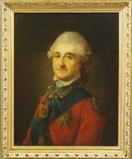
Sold201618th century portraitMarcello Bacciarelli (Attributed to) Polish/Italian, 1731-1818. Oil on canvas portrait of King Stanislaus August Poniatowski, the last King and Grand Duke of the Polish–Lithuanian Commonwealth (1764See Sold Price
Sold2022MILITARIA. The Order of Saint Stanislaus 14kt GoldMedal. A Polish–Lithuanian Commonwealth / Russian Empire Order Stanislaus Stanislas(Sw. Stanislawa Biskupa Meczennika), (Orden Svyatogo Stanislava) House of Romanov (1839) 2nd Class. Civil DivisSee Sold Price
Sold2017West Indies Islands Map, Mallet, 1683TITLE OF THE MAP: 'Is(les) de Cuba et de Iamaica' Florida is show in the distance as are the Bahamas. The top image on the right hand side shows the entire map. DATE PRINTED: 1683 IMAGE SIZE: Approx OSee Sold Price
Sold20191792 Elwe Map of Poland -- La Pologne, Divisee enTitle/Content of Map: 1792 Elwe Map of Poland -- La Pologne, Divisee en Royaume de Pologne et les Etats y Apartenans la Pologne Prussienne Autrichienne & Russienne Date: 1792, Amsterdam Cartographer:See Sold Price
Sold2017Mallet: Antique Map of Malta, 1683Title/Content of Map: 'Isle de Malthe' MALTA GOZO COMINO, Decorative vignette. Date Printed: 1683 Image Size: Approx Overall page size 13 x 21cm approximately (5 x 8 inches); image size 10.5 x 14.5cmSee Sold Price
Sold2019Kukharka Russia Poland Belarus Russian[ Lithuanian chef] Litovskaya kukharka... Sostavila Vikentiya Zavadzkaya... Izdaniye devyatoye dopolnenoye...Izdaniye knizhnago Magazina Ivosifa Zavadzkago v Vil'ne 1902. XXXI, 612 p.See Sold Price
Sold2020Stefan Norblin (Polish, 1892-1952) Poland - UpperChemins de Fer de L'Etat Polonais ca. 1925 artist's name printed in image; printed Zak?. Graf. E.i Dr. K. Kozia?skich (Varsovie-Pologne) 39.5 x 24.75 in.See Sold Price
Sold2019"Le Royaume de Pologne". Poland. SANTINI / ROBERT DETITLE/CONTENT OF MAP: 'Le Royaume de Pologne par le Sr. Robert de Vaugondy Géog. ord. du. Roi de S. M. Pol Duc de Lorr et de Bar et de l'Academie royale de Nancy. À Venise par François SantiSee Sold Price
Sold2021Kingdom of Poland-Lithuania. 1762 by Homann HeirsTitle: Kingdom of Poland-Lithuania. 1762 by Homann Heirs Date/Period: 1762 Materials: Copperplate engraved Size: 24 x 20 1/2" Shows a massive Polish-Lithuania Commonwealth. Extends from Prussia to UkrSee Sold Price
Sold2018Bonne: Antique Map of Central Europe, 1780Title/Content of Map: 'L'Allemagne, La Boheme, et La Hongrie; avec une partie de Pologne'. A map of Central Europe from the Baltic Sea to the Gulf of Venice, including present day Germany, Poland, CzeSee Sold Price
Sold2019Kociell Belarus Lithuania PolandLetter signed by the Grand Treasurer of the Lithuanian Grand Duke, Michal Kazimierz Kociell. 1713 Pop., Hand-printed, 2 pages, 34x20, embossed seal of the Grand Treasurer of the Lithuanian Grand Duke.See Sold Price
Sold2017Mallet: Antique Map of the Americas, 1683Map Title: 'Nouveau Continent avec plusieurs Isles' Australia appears partly outlined. AMERICAS SHOWING CALIFORNIA AS AN ISLAND. 'Nouveau Continent'. Date Printed: 1683 Image Size: Approx Overall pageSee Sold Price
Sold2018de la Tour: Antique Map of Poland Lithuania, 1771TITLE/CONTENT OF MAP: 'Etats de Pologne et de Lithuanie, divisés par Palatinats et Provinces Ecclesiastiques. Avec le Roiaume de Prusse et le Duché de Curlande. D'après d'exactes connaissances acquSee Sold Price
Sold2022Poland & Lithuania 1780/81 scarce map by J. B. NolinTitle: Poland & Lithuania 1780/81 scarce map by J. B. Nolin Date/Period: 1780/81 Materials: Hand colored copper plate engraved Size: 14 1/2 x 10 1/4” Shows the old large Polish-Lithuania commonwSee Sold Price
Sold2019Mallet map of island of California 1683Heading: Author: Mallet, Alain Manesson Title: Nouveau Mexique et Californie Place Published: Paris Publisher: Date Published: 1683 Description: Copper-engraved map. 14.5x1See Sold Price
Sold2017Alain Manesson Mallet: Du Globe Terrestre, 1683Map: Du Globe Terrestre Maker: Alain Manesson Mallet (1603-1706) Publisher: Paris, 1683 Size: Miniature - 5.6 x 4 in. Illustration map from his "Description de l'Univers" in 5 volumes of Paris, 1683.See Sold Price
6 days LeftJasper52GREAT TARTARY. 'Grande Tartarie'. Russia China N & Central Asia. MALLET 1683 mapUS$20
6 days LeftJasper52ASIA. 'Asie Moderne'. India China Japan Arabia Persia (Iran). MALLET 1683 mapUS$50
6 days LeftJasper52SOUTH ASIA. India Ceylon Sri Lanka Indochina Maldives. 'Inde'. MALLET 1683 mapUS$60
May 24Leland LittleA Finely Cast Silver Spoon with Figural Handle and Polish-Lithuanian Coat of ArmsUS$50
May 24Marques Dos Santos, LdaF.DE WIT - 'Regni Poloniae et Ducatus Lithuaniae Voliniae, Podoliae...'€300
588 Lots AwayPotter & Potter AuctionsFive Polish Film and Theater Posters. Includes: MLODOZENIEC...US$150
3 days LeftNeely AuctionZdzislaw Lachur (Poland 1920-2007) original oil and gouache on paper, then applied to cardboard.US$200
5 days LeftBonhamsA rare Polish sword with finely watered-steel Persian blade signed by Shaghani Poland, the blade...£20,000
375 Lots AwayPotter & Potter AuctionsPOLAND, Edwin Christian (1903 – 1991). The Evergreen Playgr...US$200
5 days LeftJasper521658 LE COMMERCE DES VIVANTS by B. Breugne antique POLAND COAT OF ARMS BINDINGUS$170
May 30Pandora AuctionsOriginal Vintage HUBERT HILSCHER Poland "CYRK" Circus Poster - LION - Ca. 1978US$170
6 days LeftKotler Galleries & AuctioneersJOZEF AUMILLER POLISH, 1892-1963 BRONZE PLAQUE MEDAL Jozef Aumiller Polish, 1892-1963 PlaqueUS$300
22 hrs LeftHeritage Auctions82021: An Imperial Fabergé Presentation Diamond and SaUS$3,400


![Kukharka Russia Poland Belarus Russian: [ Lithuanian chef] Litovskaya kukharka... Sostavila Vikentiya Zavadzkaya... Izdaniye devyatoye dopolnenoye...Izdaniye knizhnago Magazina Ivosifa Zavadzkago v Vil'ne 1902. XXXI, 612 p.](https://p1.liveauctioneers.com/6246/149562/75532021_1_x.jpg?height=310&quality=70&version=1567752154)


