Sold2022Scandinavia.- Moll (Herman) A New Map of Denmark and Sweden according to ye newest and most exactScandinavia.- Moll (Herman) A New Map of Denmark and Sweden according to ye newest and most exact observations..., large detailed map with inset map of the Northern part of Norway, Lapland and GreenlaSee Sold Price
Sold2022(AMERICAS.) Herman Moll. A Map of America According to ye Newest and Most Exact Observations.(AMERICAS.) Herman Moll. A Map of America According to ye Newest and Most Exact Observations. Engraved map of North and South America showing California as an island. 11½x7¾ inches sheet sizSee Sold Price
Sold2017Herman Moll A New Map of Great Britain 1717. TitlHerman Moll A New Map of Great Britain 1717. Title: 'A New Map of Great Britain According to the Newest and Most Exact Observations'. A large and very intricate map of the British isles with colouredSee Sold Price
Sold2017A New and Exact Map of France Dividid HERMAN MOLLDetails: MOLL, Herman (fl. 1678-1732). A New and Exact Map of France Dividid [sic] into all its provinces and acquisitions, according to the newest observations, and that accurate survey made by theSee Sold Price
Sold2019Moll map with California an Island. 1708Heading: Author: Moll, Herman Title: A Map of America. According to ye Newest and Most Exact Observations Place Published: London Publisher: Date Published: 1708 Description:See Sold Price
Sold2023Eglomise World Map Coffee Table20th century reverse-painted glass coffee table with reproduction of the 1730 original by Herman Moll, titled "A New and Correct Map of the World Laid Down According to the Newest Discoveries and FromSee Sold Price
Sold2016America by Herman Moll 1716Map Title: America, According to the Newest and Most Exact Observations Maker: Herman Moll Date: 1716 Origin: Atlas Geographicus Size: 13 x 16 inches Medium: Copperplate engraving Herman Moll (1654-17See Sold Price
Sold2022MAP, China, Korea & Japan, MollChina, Korea & Japan. Herman Moll, China According to the Newest and Most Exact Observations, 1720 (circa). Hand Color. Nice copper engraved map in Moll's typical style presents the Korean peninsula,See Sold Price
Sold2023Print, Herman MollHerman Moll (British, 1654-1732), "A New and Exact Map of the Coast, Countries and Islands within ye Limits of ye South Sea Company, from ye River Aranoca to Tierra del Fuego, and from thence throughSee Sold Price
Sold2022BEAVER MAP, HERMAN MOLL (DUTCH/BRITISH, 1654-1732)A New and Exact Map of the Dominions of the King of Great Britain on ye Continent of North America containing Newfoundland, New Scotland, New England, New York, New Jersey, Pensilvania, Maryland, VirgSee Sold Price
Sold2017Moll: Antique Map of Arabia, 1712Title: Arabia, According to the Newest and most Exact Observations. 1712 Moll map of Arabia with Hajj route from Basra Map maker: Herman Moll Place and Year: London, c. 1712 Dimensions: 17.5 x 25.5 cmSee Sold Price
Sold2024Herman Moll A New Map of Ye North Parts of AmericaHerman Moll (British, 1654-1732). Colored engraved map, A New Map of Ye North Parts of America Claimed by France Under Ye Names of Louisiana, Mississipi [sic], Canada & New France, With the AdjoiningSee Sold Price
Sold2022MOLL, HERMAN. A New Map of the North Parts of America claimed by France under ye Names of Louisiana,MOLL, HERMAN. A New Map of the North Parts of America claimed by France under ye Names of Louisiana, Mississipi, Canada and New France with ye Adjoyning Territories of England and Spain. Large engraveSee Sold Price
Sold2022Italy.- Moll (Herman) A New Map of the Upper Part of Italy, engraved map with hand-colouring, [c.Italy.- Moll (Herman) A New Map of the Upper Part of Italy, containing ye Principality of Piedmont by ye Dutchies of Savoy, Milan, Parma, Mantua, Modena, Tuscany, the Dominions of ye Pope, &c. The RepSee Sold Price
Sold2022Herman Moll's New Map of the World - California as an Island!, Ca. 1725Herman Moll's New Map of the World - California as an Island!, Ca. 1725 1p, measuring 13.625" x 8.5", n.p., ca. 1725. A hand-colored map entitled "A New Map of the World according to the New ObservatiSee Sold Price
Sold2024Map of the North Parts of America Claimed by France by Herman Moll (London, 1720)Map of the North Parts of America Claimed by France by Herman Moll (London, 1720) "A New Map of the North Parts of America claimed by France under ye Names of Louisiana, Mississippi, Canada, and New FSee Sold Price
Sold2017Moll - Correct Map of the Whole World, 1719Herman Moll (1654?-1732), cartographer and publisher A New & Correct Map of the Whole World Shewing y.e Situation of its Principal Parts. Viz the Oceans, Kingdoms, Rivers, Capes, Ports, Mountains, WooSee Sold Price
Sold20221800 Payne Map of Scandinavia -- Sweden Denmark & Norway from the Latest AuthoritiesTitle: 1800 Payne Map of Scandinavia -- Sweden Denmark & Norway from the Latest Authorities Cartographer: J Payne Year / Place: 1800, New York Map Dimension (in.): 7.4 X 8.4 in. This is a lovely map oSee Sold Price
Sold2022World.- Speed (John) A New and Accurat Map of the World Drawne according to ye truest DescriptionsWorld.- Speed (John) A New and Accurat Map of the World Drawne according to ye truest Descriptions latest Discoveries & best observations yt have beene made by English or Strangers, double-hemisphereSee Sold Price
Sold2016JOHN SPEED (BRITISH, 1552-1629) MAP OF THE WORLDJOHN SPEED (BRITISH, 1552-1629) MAP OF THE WORLD, (UPDATED 6/14/16) hand-colored engraving on laid paper, titled "A New and Accurat Map of the World Drawne according to ye truest Descriptions latest DSee Sold Price
Sold2017FRAMED WORLD MAP BY HERMAN MOLL, 1719'A New & Correct Map of the Whole World, by Herman Moll, Geographer, 1719.' Hand tinted and framed. Frame size: 73 x 124 cm (28 3/4 x 48 3/4 in.)See Sold Price
Sold2024John Bowles (British 1709 - 1779)John Bowles (British 1709 - 1779) "A New and Exact Map of America Laid Down from the Latest Observations and Discoveries", circa 1750 Two sheet map engraving of the "Representation of the Customs andSee Sold Price
Sold20201763 Map Of Province Of Quebec, Captain Carver1763 Map Of Province Of Quebec, Captain Carver. A New Map Of The Province Of Quebec, According To The Royal Proclamation, Of The 7th Of October 1763 : From The French Surveys Connected With Those MadeSee Sold Price
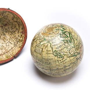
Sold2023(GLOBES.) Style of Herman Moll. A Correct Globe with the New Discoveries.(GLOBES.) Style of Herman Moll. A Correct Globe with the New Discoveries. 2¾-inch miniature terrestrial pocket globe comprised of 12 hand-colored engraved gores and 2 polar calottes on a plasterSee Sold Price
5 days LeftZikorn Arts & History ObjectsEntrance to Baltic Great & Little Belt 1852 British Admiralty MapUS$100
2 hrs LeftCrescent City Auction GalleryWilliam H. Williams (1817-1886), New Orleans "Map of the Sixth District and Carrollton," 1871, H.-US$650
3 days LeftFleischer's Auctions1755 Map Partie de l'Amerique Septentrionale, qui comprend Le Cours de L'Ohio...US$200(3 bids)
3 hrs LeftHess Fine AuctionsLot of Two Antique Violins & Two Bows Herman Rainer Antonius Stradivarius 1716 Copy & Unbranded No36US$30(3 bids)
May 18Nadeau's Auction GalleryHerman Miller Eames 670 Red Leather and Rosewood Lounger with OttomanUS$1,200(2 bids)
May 21Freeman's | HindmanFrits Henningsen (Danish, 1889-1965) Leather High-Back Settee, c. 1930US$7,500


![A New and Exact Map of France Dividid HERMAN MOLL: Details: MOLL, Herman (fl. 1678-1732). A New and Exact Map of France Dividid [sic] into all its provinces and acquisitions, according to the newest observations, and that accurate survey made by the](https://p1.liveauctioneers.com/5671/103625/53044992_1_x.jpg?height=310&quality=70&version=1494009518)


![Herman Moll A New Map of Ye North Parts of America: Herman Moll (British, 1654-1732). Colored engraved map, A New Map of Ye North Parts of America Claimed by France Under Ye Names of Louisiana, Mississipi [sic], Canada & New France, With the Adjoining](https://p1.liveauctioneers.com/7691/320359/172153415_1_x.jpg?height=310&quality=70&version=1708543789)