Sold2018Tanner / Reid Map of South Carolina, 1796Tanner, Benjamin (1775-1848). State of South Carolina from the Best Authorities. Engraved map. J. Reid, 1796. 15" x 17" sheet. Published by John Reid New York. A very early and scarce folio map of SouSee Sold Price
Sold2019[Map] The State of South Carolina 1796Tanner, Benjamin. "The State of South Carolina: from the best Authorities." New York: John Reid, [ca. 1796.] On heavy laid. Measuring from neat-lines 17" x 15". Lower edge remargined, mild toning, oneSee Sold Price
Sold2022Three 18th Century North Carolina Mapsengravings on laid paper, all unframed, including: John Reid, The State of North Carolina From the Best Authorities, engraver Benjamin Tanner, New York, circa 1796, sheet 16-1/2 x 19 in.; Matthew CareSee Sold Price
Sold2018Tanner: Antique Map of South Carolina, 1843Title/Content of Map: South Carolina by Tanner Date Printed: 1843 Cartographer: H.C. Tanner Material/Medium: Paper Size: 17" x 14" Hand colored engraved Map based on the work of H.C. Tanner from the fSee Sold Price
Sold20211796 MAP OF NORTH & SOUTH CAROLINA, DENISON, FRAMEJ. Denison (American, 18th century). "Map of North and South Carolina" -1796, from "Morse's Universal Geography", engraving. Framed. Provenance: From the Lifetime Collection of Billy S. Arant, Jr., ChSee Sold Price
Sold202119th c. NEW MAP OF SOUTH CAROLINARare 19th c. A New Map of South Carolina with its Canals, Roads & Distances from place to place along the Stage & Steam Boat Routes. By H.S. Tanner c. 1841-1845. Fine example of Tanner's map of SouthSee Sold Price
Sold2021Map of North and South CarolinaMap is North and South Carolina by H. S. Tanner North and South Carolina 1825 printed in 1967 by Lewis and Clark explorer maps LTD Kitty Hawk North Carolina re-printed from the original map publishedSee Sold Price
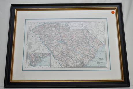
Sold2021Soil Map. South Carolina Darlington SheetPublication Date: 1902 Title: Soil Map. South Carolina Darlington Sheet Cartographer: RICE, T. D. / F. W. TAYLOR Publisher: U.S. DEPARTMENT OF AGRICULTURE. (BUREAU OF SOILS) Height: 30.6 Width: 34 ColSee Sold Price
Sold2017Colton: Antique Pre Civil War Map South Carolina, 1861Title/Content of Map: Pre Civil War South Carolina by Colton Date Printed: 1861 Cartographer: J.H. Colton Material/Medium: Paper Size: 17 1/2" x 14" Hand colored steel engraved Map from 'Colton's GeneSee Sold Price
Sold2018South Carolina by ColtonTitle/Content of Map: South Carolina by Colton Date: 1871 Cartographer: G.W. Colton Material/Medium: Paper Size: 14" x 17" Provenance: New York Hand colored lithograph. Published in New York in 'ColtoSee Sold Price
Sold2018South Carolina by BradfordTitle/Content of Map: South Carolina by Bradford Date Printed: 1838/41 Cartographer: Thomas G. Bradford Material/Medium: Paper Size: 14" x 16" Provenance: New York A General Atlas of the World with aSee Sold Price
Sold2018Colton: Antique Map of South Carolina, 1871Title/Content of Map: South Carolina by Colton Date Printed: 1871 Cartographer: G.W. Colton Material/Medium: Paper Size: 17" x 14" Hand colored lithograph. From 'Colton's American Atlas'. Published inSee Sold Price
Sold2023Emanuel Bowen Map North & South Carolina, Georgia[Emanuel Bowen Map of North & South Carolina and Georgia] , "A New & Accurate Map of the Provinces of North & South Carolina Georgia & c. Drawn from late Surveys and regulated by Astron Observat. By ESee Sold Price
Sold2023Extremely scarce map of South Carolina (1814)Scarce third state of Samuel Lewis’s map of South Carolina, appearing in the extremely scarce 1816 edition of Carey’s General Atlas (same map as in the 1814 Carey atlas). One of the earlieSee Sold Price
Sold20211779 NEW AND ACCURATE MAP OF SOUTH CAROLINAA New And Accurate Map Of The Province Of South Carolina In North America. London: Universal Magazine, c. 1779. Good, showing folds, 2 small tears to edges. Narrow margins. The map shows trails and paSee Sold Price
Sold2021RR map of South Carolina, 1853Nice railroad map of South Carolina with railroad lines highlighted in red overlay hand color to make them stand out (done at the time it was published in 1853). Shows counties, towns, rivers, lakes,See Sold Price
Sold20192 Hand Colored Maps - Georgia & South CarolinaTwo Gray's Atlas Maps on one sheet - Georgia and South Carolina Inset of Charleston on South Carolina map. Depicts railroad lines, common roads, canals, topography,See Sold Price
Sold20191807 Map Charleston, South CarolinaPublished Philadelphia by C.P. Wayne. The piece titled ÒPlan of the Siege of Charleston in S. CarolinaÓ. Sight size: H10" W15" (without frame)See Sold Price
Sold2017Meyer: Antique Map of South Carolina & Charleston, 1852Map: Neueste Karte von Sud Carolina Cartographer: Bibliographischen Instituts. Place & Date: Hildburghausen / 1852 Size: 14 5/8" x 11 3/4" Condition: original color; overall age toning The beautifullySee Sold Price
Sold2021Important 1850s map of South Carolina, CowperthwaitThroughout the first half of the 1850s, Thomas, Cowperthwait & Co. produced wonderful, highly detailed maps of the United States, including individual states. The maps were essentially the same engravSee Sold Price
Sold2021HAMMONDS COMPLETE MAP OF SOUTH CAROLINAVintage Hammonds Complete Map of South Carolina. Showing all the railroad routes. c. 1930s. Professionally framed and matted. In frame measures 26 3/4"x20"x 1 1/4". Weight 7 pds. PROVENANCE: A PrivateSee Sold Price
Sold20231855 Colton Map of South Carolina -- South CarolinaTitle: 1855 Colton Map of South Carolina -- South Carolina Cartographer: J Colton Year / Place: 1855, New York Map Dimension (in.): 11.8 X 14.5 in. This is a very nice map of South Carolina with insetSee Sold Price
Sold20211938 R Taylor White Pictorial Map of South Carolina --Title: 1938 R Taylor White Pictorial Map of South Carolina -- South Carolina Cartographer: Ruth Taylor White Year / Place: 1938, Boston Map Dimension (in.): 11.6 x 8.5 in. This is Ruth Taylor White'sSee Sold Price
Sold20221938 R Taylor White Pictorial Map of South Carolina -- South CarolinaTitle: 1938 R Taylor White Pictorial Map of South Carolina -- South Carolina Cartographer: Ruth Taylor White Year / Place: 1938, Boston Map Dimension (in.): 11.6 x 8.5 in. This is Ruth Taylor White'sSee Sold Price
May 18Blackstone Valley Auctions & Estates LLCRevolutionary Era War Map of the Attack on Ft. Moultrie.US$120(2 bids)
3 days LeftBK AuctionsDecember 23 1776 $8 South Carolina Colonial Note Fr. SC-141 PMG About Uncirculated 55US$1
May 21Freeman's | HindmanHungarian Art Deco Pair of Hungarian Walnut Armchairs, c. 1940US$1,000(1 bid)
3 days LeftFleischer's AuctionsNathan Bedford Forrest "Dealers in Slaves" 1860 AdvertisementUS$200(2 bids)


![[Map] The State of South Carolina 1796: Tanner, Benjamin. "The State of South Carolina: from the best Authorities." New York: John Reid, [ca. 1796.] On heavy laid. Measuring from neat-lines 17" x 15". Lower edge remargined, mild toning, one](https://p1.liveauctioneers.com/3532/146911/74242458_1_x.jpg?height=310&quality=70&version=1564368564)


![Emanuel Bowen Map North & South Carolina, Georgia: [Emanuel Bowen Map of North & South Carolina and Georgia] , "A New & Accurate Map of the Provinces of North & South Carolina Georgia & c. Drawn from late Surveys and regulated by Astron Observat. By E](https://p1.liveauctioneers.com/268/293228/155705053_1_x.jpg?height=310&quality=70&version=1687296979)


![[Civil War] 1862 “Servant” Slave Badge (1 of 2)](https://p1.liveauctioneers.com/7226/322253/173251645_1_x.jpg?height=282&quality=70&version=1710004847)


