Sold2024ARMY OF THE CUMBERLAND MAP VINTAGE ANTIQUEARMY OF THE CUMBERLAND MAP VINTAGE ANTIQUESee Sold Price
Sold2024BARTHOLOMEWS REVISED HALF INCH CONTOURED MAPS VINTAGE ANTIQUEBARTHOLOMEWS REVISED HALF INCH CONTOURED MAPS VINTAGE ANTIQUESee Sold Price
Sold2023L'Africa. DE ROSSI / SANSON 1677 old antique vintage map plan chartTITLE/CONTENT OF MAP: L'Africa [Africa] DATE PRINTED: 1677 IMAGE SIZE: Approx 42.5 x 57.0cm, 16.75 x 22.25 inches (Large) TYPE: Antique 17th century folio atlas map CONDITION: Good; suitable for framiSee Sold Price
Sold2024L'Europa. Europe. DE ROSSI 1677 old antique vintage map plan chartTITLE/CONTENT OF MAP: L'Europa [Europe] DATE PRINTED: 1677 IMAGE SIZE: Approx 44.0 x 56.5cm, 17.25 x 22.25 inches (Large) TYPE: Antique 17th century folio atlas map CONDITION: Good; suitable for framiSee Sold Price
Sold2023L'Europe. Europe. BONNE 1780 old antique vintage map plan chartTITLE/CONTENT OF MAP: 'L'Europe' A map of Europe DATE PRINTED: 1780 IMAGE SIZE: Approx 23.0 x 34.0cm, 9 x 13.5 inches (Large); Please note that this is a folding map. TYPE: Antique copperplate engraveSee Sold Price
2022Havana. Cuba 1885 old antique vintage map plan chartTITLE/CONTENT OF MAP: 'Havana' DATE PRINTED: 1885 IMAGE SIZE: Approx 22.5 x 29.0cm, 8.75 x 11.25 inches (Large); Please note that this is a folding map. TYPE: Antique colour map; Scale 1:14,000 CONDITSee Sold Price
Sold2023HOLY ROMAN EMPIRE. Europe in 1360 1902 old antique vintage map plan chartTITLE/CONTENT OF MAP: 'Europe in 1360' DATE PRINTED: 1902 IMAGE SIZE: Approx 25.0 x 33.5cm, 10 x 13.25 inches (Large) TYPE: Antique colour map. This map was published in 1902 but it may depict an earlSee Sold Price
Sold2024CENTRAL ASIA. Turkestan & Inner c1885 old antique vintage map plan chartTITLE/CONTENT OF MAP: 'Turkestan and Inner Asia' DATE PRINTED: c1885 IMAGE SIZE: Approx 25.0 x 31.0cm, 9.75 x 12.25 inches (Large); Please note that this is a folding map. TYPE: Antique coloured engraSee Sold Price
Sold2024Europe by Arrowsmith & Lewis 1812 old antique vintage map plan chartTITLE/CONTENT OF MAP: 'Europe' DATE PRINTED: 1812 IMAGE SIZE: Approx 25.0 x 20.0cm, 9.75 x 8 inches (Medium) TYPE: Antique steel engraved map CONDITION: Good; suitable for framing. Please check the scSee Sold Price
Sold2024ASIA. Hypsographical c1885 old antique vintage map plan chartTITLE/CONTENT OF MAP: 'Hypsographical Map of Asia' DATE PRINTED: c1885 IMAGE SIZE: Approx 23.5 x 30.0cm, 9.25 x 11.75 inches (Large); Please note that this is a folding map. TYPE: Antique coloured engSee Sold Price
Sold2022Western division of Cuba 1885 old antique vintage map plan chartTITLE/CONTENT OF MAP: 'Western division of Cuba' DATE PRINTED: 1885 IMAGE SIZE: Approx 13.0 x 11.5cm, 5 x 4.5 inches (Small) TYPE: Antique wood-engraved map; Scale 1:6,000,000 CONDITION: Good; suitablSee Sold Price
Sold2024Isothermals of the Pacific Ocean 1886 old antique vintage map plan chartTITLE/CONTENT OF MAP: 'Isothermals of the Pacific' DATE PRINTED: 1886 IMAGE SIZE: Approx 19.0 x 26.5cm, 7.5 x 10.5 inches (Medium); Please note that this is a folding map. TYPE: Antique engraved colouSee Sold Price
Sold2024ASIA. Azië (2) 1922 old antique vintage map plan chartTITLE/CONTENT OF MAP: 'Azië' DATE PRINTED: 1922 IMAGE SIZE: Approx 20.5 x 23.5cm, 8 x 9.25 inches (Medium) TYPE: Vintage colour map: Schaal 1: 56,000,000 CONDITION: Good; suitable for framing. PlSee Sold Price
Sold2024ASIA. Azië (1) 1922 old antique vintage map plan chartTITLE/CONTENT OF MAP: 'Azië' DATE PRINTED: 1922 IMAGE SIZE: Approx 20.5 x 23.5cm, 8 x 9.25 inches (Medium) TYPE: Vintage colour map: Schaal 1: 56,000,000 CONDITION: Good; suitable for framing. PlSee Sold Price
Sold2024Asia (Physical). Elevation. Mountains 1907 old antique vintage map plan chartTITLE/CONTENT OF MAP: 'Asia (Physical)' DATE PRINTED: 1907 IMAGE SIZE: Approx 16.5 x 21.5cm, 6.5 x 8.25 inches (Medium); Please note that this is a folding map. TYPE: Vintage colour map CONDITION: GooSee Sold Price
Sold2023Isothermal lines of South America 1885 old antique vintage map plan chartTitle: Isothermal lines of South America 1885 old antique vintage map plan chart Description: Isothermal lines of South America' by Engraved for Élisée Reclus (1885). Antique wood-engraved mSee Sold Price
Sold2023SOUTH AMERICA. Britannica 9th edition 1898 old antique vintage map plan chartTitle: SOUTH AMERICA. Britannica 9th edition 1898 old antique vintage map plan chart Description: South America' by Britannica, Encyclopaedia (1898). Antique coloured map, 32.5 x 25.0cm, 12.75 x 9.75See Sold Price
Sold2021MIXED INFO MAP LOT ADVERTISING VINTAGE ANTIQUEMIXED INFO MAP LOT ADVERTISING VINTAGE ANTIQUE *** Thank you for attending HATMAN AUCTIONS! Yes, we ship all items that are not oversized. Please see photos for measurements and description This is thSee Sold Price
Sold2024BARTHOLOMEWS QUARTER INCH MAPS OF SCOTLAND VINTAGE ANTIQUEBARTHOLOMEWS QUARTER INCH MAPS OF SCOTLAND VINTAGE ANTIQUESee Sold Price
Sold2020Antique / Vintage Maps,Photos, Papers, More - AsstAntique / Vintage Maps,Photos, Papers, More - Asst Advertising, StereoViews, Manuals & MoreSee Sold Price
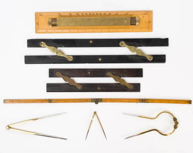
Sold2021Antique & Vintage Marine Map Chart AccessoriesA group of six very good marine map chart accessories, consisting of: two antique ebony & brass parallel rules - the 12" rule stamped THREADWELL LONDON, the 18" rule with minor chips, a 15" antique brSee Sold Price
4 days LeftJasper52Sierra Nevada de Santa Marta. Colombia 1885 old antique vintage map plan chartUS$8
4 days LeftJasper52South America. Large 64x51cm. STANFORD 1904 old antique vintage map plan chartUS$50
4 days LeftJasper52Density of population in South America 1885 old antique vintage map plan chartUS$8
4 days LeftJasper52Political divisions of Central America 1885 old antique vintage map plan chartUS$8
4 days LeftJasper52SOUTH AMERICA. Britannica 9th edition 1898 old antique vintage map plan chartUS$10


![L'Africa. DE ROSSI / SANSON 1677 old antique vintage map plan chart: TITLE/CONTENT OF MAP: L'Africa [Africa] DATE PRINTED: 1677 IMAGE SIZE: Approx 42.5 x 57.0cm, 16.75 x 22.25 inches (Large) TYPE: Antique 17th century folio atlas map CONDITION: Good; suitable for frami](https://p1.liveauctioneers.com/5584/308981/165185503_1_x.jpg?height=310&quality=70&version=1699996168)
![L'Europa. Europe. DE ROSSI 1677 old antique vintage map plan chart: TITLE/CONTENT OF MAP: L'Europa [Europe] DATE PRINTED: 1677 IMAGE SIZE: Approx 44.0 x 56.5cm, 17.25 x 22.25 inches (Large) TYPE: Antique 17th century folio atlas map CONDITION: Good; suitable for frami](https://p1.liveauctioneers.com/5584/322790/173578184_1_x.jpg?height=310&quality=70&version=1710881198)