Sold2022Transport Map of Central Europe. Railways mail routes. LARGE 1959 oldTITLE/CONTENT OF MAP: 'Transport Map of Central Europe' DATE PRINTED: 1959 IMAGE SIZE: Approx 49.5 x 72.0cm, 19.5 x 28.25 inches (Large); Please note that this is a folding map. TYPE: Antique colour mSee Sold Price
Sold2023Baltic Sea sea chart. Ports lighthouses mail routes dockyards. LARGE 1959 mapTITLE/CONTENT OF MAP: 'Central European states - Political' Czechoslovakia includes Carpathian Ruthenia, which it administered until it was occupied and annexed by Hungary in 1939; it was subsequentlySee Sold Price
Sold2022EUROPE & MEDITERRANEAN. Relief. Railways. Shipping routes. BARTHOLOMEW 1912 mapTITLE/CONTENT OF MAP: 'Central Europe and The Mediterranean' DATE PRINTED: 1912 IMAGE SIZE: Approx 33.5 x 44.5cm, 13.25 x 17.5 inches (Large); Please note that this is a folding map. TYPE: Antique colSee Sold Price
Sold2019Gross, Alexander 1920 Mixed Lot of 7 Large MapsIncl Austria, Europe, Europe - Political, Central Europe - Railways, Mediterranean Sea, South Atlantic Ocean, and North Atlantic Ocean. Large Lithograph Maps Published 1920, London for "The Daily TeleSee Sold Price
Sold2024Central Europe with Railways: operating & under construction. SWANSTON 1860 mapCAPTION PRINTED BELOW PICTURE: 'Central Europe with Railways' DATE PRINTED: 1860 IMAGE SIZE: Approx 44.5 x 55.0cm, 17.5 x 21.75 inches (Large); Please note that this is a folding map. TYPE: Antique atSee Sold Price
Sold2022EUROPE. INDUSTRIES. Coal & Iron deposits. British consuls. Railways 1920 mapTITLE/CONTENT OF MAP: 'Central & Western Europe (Industrial)' DATE PRINTED: 1920 IMAGE SIZE: Approx 34.0 x 45.0cm, 13.25 x 17.5 inches (Large) TYPE: Vintage colour map CONDITION: Good; suitable for frSee Sold Price
Sold2024MEDITERRANEAN & BLACK SEAS showing steamship routes & railways 1911 old mapTITLE OF THE MAP: 'The Mediterranean; Inset Canary Islands' DATE PRINTED: 1911 IMAGE SIZE: Approx 27.0 x 51.0cm, 10.75 x 20 inches (Large); Please note that this is a folding map. TYPE: Antique colourSee Sold Price
Sold2023Eastern Europe sea chart Ports Lighthouses mail route Black Sea Baltic 1918 mapTITLE/CONTENT OF MAP: 'Eastern European Ports and Waterways' DATE PRINTED: 1918 IMAGE SIZE: Approx 49.0 x 34.0cm, 19.25 x 13.5 inches (Large) TYPE: Antique colour maritime map chart; Scale 1:20,000,00See Sold Price
Sold2024AN OLD SILK RUG, PERSIAA large central medallion on light ground within floral frame. Floral ornamented borders. 155X105 cm.See Sold Price
Sold202113-Star Civil War Vintage Flag. 63" x 34" light-13-Star Civil War Vintage Flag. 63" x 34" light-weight cotton, stars arranged in a medallion pattern with large central star and stars in each corner. Twill cotton sleeve with rope insert. Four old reSee Sold Price
Sold2022Antique Khotan Tiger Oriental Rug- 4'8'' x 8'8''Antique Khotan Tiger Oriental Rug. Measure 4'8'' x 8'8''. Purple field with large central Tiger, coin and medallion border. Scattered wear with a few small old repairs.See Sold Price
Sold2019A platinum Art Deco 2.7 ct diamond ringThe Platinum ring is set with a large and impressive 2.7 ct old cut diamond(SI2 I-K) Three princess cut diamonds flank the central diamond on each side. weight: 7.4 grams US ring size: 8See Sold Price
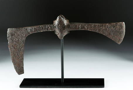
Sold2018Large 7th C. Viking / Anglo-Saxon Iron Broad-Axe HeadNorthern Europe, Viking, Anglo-Saxon, or possibly other Germanic, ca. 7th to 9th century CE. Both magnificent and terrifying, an enormous cast-iron, double-headed broad-axe with a central socketing shSee Sold Price
Sold2018India.- Joseph (Charles) Map of the Grand Trunk RoadIndia.- Joseph (Charles) Map of the Grand Trunk Road from the Karamnassa to the Sutledge, Part Second, from Agra to Ferozepoor, large folding road map of one of the oldest and longest trade routes linSee Sold Price
Sold2022Mitchell's large Mexican-American War map, 1847Heading: Author: Mitchell, Samuel Augustus Title: Map of Mexico, Including Yucatan & Upper California, Exhibiting the Chief Cities and Towns, the Principal Travelling Routes &c. Place Published: PhilSee Sold Price
Sold2022JEWELRY. 18kt and 14kt Gold, Enamel and DiamondBracelet. Antique jarretiere or buckle form 14kt yellow gold bracelet displaying a large woven 18kt gold pendant with a central bezel set oblong Old European cut diamond with a surround of (12) Old EuSee Sold Price
Sold2020Royal Vienna Gilt wood & Porcelain Side Table19TH C. ROYAL VIENNA GILT WOOD & PORCELAIN SIDE TABLE. 19th century Austrian Royal Vienna gilt wood table, inset with hand painted porcelain plaques. Central large plaque depicting an interior vanitySee Sold Price
Sold2021Fine Art Deco, Platinum 18K Gold and Diamond Earringsin the form of stylized snowflakes, with millegrain finish and openwork gallery, containing two central old European cut natural diamonds (G-I SI2) weighing approximately 2.65 carats total, two old EuSee Sold Price
Sold2022DIAMOND THREE-STONE RINGDIAMOND THREE-STONE RING The central old brilliant-cut diamond weighing 2.22 carats, between two similarly-cut diamonds weighing 1.20 carats and 0.97 carat, ring size approx. LSee Sold Price
Sold2018Massive Bronze Age Spiral Fibula & Matching PinCentral Europe, late Bronze Age, ca. 1250 to 850 BCE. One of the most outstanding bronze fibulas we have ever seen, this sizable and elegant fibula brooch formed from intricately wound and arranged brSee Sold Price
Sold2024Variety Strand of Vintage Dominican Blue Amber Beads NecklaceRare Variety Strand of Vintage Dominican Blue Amber Beads Necklace. Diameter approx 12.7mm16.3, the central large bead diameter 23.4mm, Total Weight: 52.1g (Stand Not Included)See Sold Price
Sold2021Town of Saug - SBL: 8.4-5.23 - Old Route 32PARCEL #70 TOWN: SAUGERTIES ASSESSED TO: RUCKER HENRY D RUCKER MARY M CURRENT OWNER: COUNTY OF ULSTER SBL#: 008.004-0005-023.000-0000 CLASSIFICATION: 314 LOCATION: OLD ROUTE 32 ACREAGE: 1.50 FRONT FOOSee Sold Price
2017Antique Platinum GIA Diamond Engagement Ring, 5.8ctAntique engagement ring with large outstanding Old European cut diamond color O-P clarity VS1 ring is so brilliant and gorgeous. If you are looking for a stunning antique engagement ring, this is undoSee Sold Price
Sold2021Iron Red with Blue and White Jar, Zhengde periodA Chinese blue and white glazed jar with iron red paint details dating from the Zhengde period of Ming dynasty. The mouth and foot have blue lotus tracery bands, and there is a large central band of rSee Sold Price
3 days LeftJasper52Western Mediterranean sea chart. Ports lighthouses mail routes. LARGE 1959 mapUS$45
3 days LeftJasper52Baltic Sea sea chart. Ports lighthouses mail routes dockyards. LARGE 1959 mapUS$25
3 days LeftJasper52North Sea sea chart. Ports lighthouses mail routes. UK Norway &c LARGE 1959 mapUS$45
3 days LeftJasper52EUROPE RAILWAYS. double & single track. Narrow gauge. Steamship routes 1920 mapUS$20
3 days LeftJasper52Eastern Mediterranean & Black Sea chart. Ports lighthouses mail. LARGE 1959 mapUS$45
Featured3 days LeftJasper52Baltic Sea sea chart. Ports lighthouses mail routes dockyards. LARGE 1952 mapUS$40
3 days LeftJasper52North Sea sea chart. Ports lighthouses mail routes. UK Norway &c LARGE 1952 mapUS$40
3 days LeftJasper52Central Europe roads canals railways Germany, Holland & Belgium. HUGHES 1862 mapUS$25
3 days LeftJasper52Central Europe roads canals railways Germany, Holland & Belgium. HUGHES 1856 mapUS$25
Featured3 days LeftJasper52Johnson's Europe. Navigators' routes. Continental Shelf 1861 old antique mapUS$65
3 days LeftJasper52Eastern Europe sea chart Ports Lighthouses mail route Black Sea Baltic 1916 mapUS$40
4 days LeftPotter & Potter AuctionsTerritory of Alaska / Alaska Steamship Company. 1936. Seatt...US$100
4 days LeftPotter & Potter AuctionsUniversity of Illinois Football 1930. Bradbury. Color offse...US$350(1 bid)