Sold2024Map of California, Utah, Oregon,New Mexico 1853Map of California, Utah, Oregon,New Mexico, Washington and Nebraska Hand colored. Map No 10 United States Cartographer: Jules Sherman Smith Publisher Daniel Burgess Dated: 1853<See Sold Price
Sold2019USA 1911 Lot of 12 State Maps incl Texas & CaliforniaIncl Utah, New Jersey, Nebraska, Washington, Arkansas, Oregon, Texas, California and Nevada, Maine, Maryland and Delaware, Massachusetts, and South Eastern Pennsylvania. Lithograph Maps Published 1911See Sold Price
Sold2022Jacob Monk Wall Map of North America 1860Monk's Standard American Map exhibiting the larger portion of North America Embracing The United States and Territories, Mexico, Central America, including the West India Islands, Canada, New BrunswicSee Sold Price
Sold2022MITCHELL, S. AUGUSTUS. A New Map of Texas, Oregon and California.MITCHELL, S. AUGUSTUS. A New Map of Texas, Oregon and California. Engraved pocket map of the American territories west of the Mississippi River. 22¾x21 inches overall, ample margins; strong origiSee Sold Price
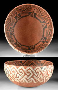
Sold2021Published Native American St. John's Pottery BowlSouthwestern USA, east central Arizona/west southern New Mexico, Ancestral Puebloan (Anasazi), ca. 1175 to 1300 CE. A splendid vessel of hemispherical form and vibrant coloring, created using the coilSee Sold Price
Sold2024Wah To Yah & The Taos Trail [181869]Hardcover, 289 pages, Grabhorn Press, 1936. Wah-To-Yah & The Taos Trail Prarie Travel And Scalp Dances by Lewis H. Garrard. Separate map of Indian Territory of North Texas and New Mexico.See Sold Price
Sold2018Colton Map of Nebraska and KansasCOLTON, Joseph H. (1800-1893). Nebraska & Kansas. Lithograph with handcolor in part. New York, 1857. 30 1/2 x 22 1/2 inches sheet, 40 x 32 inches framed Striking map of Kansas and Nebraska, includingSee Sold Price
Sold2022(KANSAS TERRITORY.) Otis B. Gunn. Gunn's New Map of Kansas and the Gold Mines(KANSAS TERRITORY.) Otis B. Gunn. Gunn's New Map of Kansas and the Gold Mines Embracing all the Public Surveys up to the 6th Principal Meridian. Compiled from the Original Field Notes by O.B. Gunn. LaSee Sold Price
Sold2022Antique Powel and Kingmans New Mexico MapSouth Western New Mexico, 1883. 34 x 46 inchesSee Sold Price
Sold2022Elmer Wayne Schooley(New Mexico/Kansas, 1916-2007), Unfinished #2, unsigned, oil on canvas, 24 x 28 in.; gallery frame, 25-5/8 x 29-5/8 in.Note: The lot is accompanied by a copy of the receipt from Meyer East Gallery, SaSee Sold Price
Sold2020A Late Classic Navajo child's wearing blanketFourth-quarter 19th Century, Fort Wingate, New Mexico Territory Woven red field of American flannel, with four columns of yellow, green and red crosses, side elements in cream and indigo blue with otSee Sold Price
Sold2023Fritz Scholder (Luiseño, 1937-2005) Mystery Woman in Mission Chair, 1987Fritz Scholder (Luiseño, 1937-2005) Mystery Woman in Mission Chair, 1987 acrylic on canvas signed Scholder (lower left) 40 x 30 inches Provenance: Sena Galleries West, Santa Fe, New MexicoSee Sold Price
Sold202220th C. Native American Hopi Painted Wood KachinaNative American, Southwestern USA, Arizona or New Mexico, Hopi Peoples, ca. early to mid-20th century CE. A hand-carved wood kachina boasting a simplistic form of a sizeable head with a prominent chinSee Sold Price
Sold2017Polly Apfelbaum, Rainbow Love Mountain Ranch, NMPolly Apfelbaum Rainbow Love Mountain Ranch, New Mexico USA, 2007lithograph on paper36.5 h x 26 w in (93 x 66 cm) Signed, dated and numbered to lower edge: [AP 1/5 PA 07]. This work is number 1 oSee Sold Price
Sold2023MITCHELL'S NEW MAP of TEXAS, OREGON & CALIFORNIA1846 Philadelphia, S. Augustus Mitchell. hardcover leather bound. 5 1/4 x 3 1/4 inches. Map unfolded 22 x 20 1/2 inches and presented in a custom frame 23 1/2 x 22 inches (overall)See Sold Price
Sold2021A New Map of Texas, Oregon and California"A New Map of Texas, Oregon and California with the Regions Adjoining" by S. Augustus Mitchell, engraving with hand-coloring, 1st edition, published Philadelphia, 1846; framed together with original bSee Sold Price
Sold2023Mitchell's A New Map of Texas, Oregon and CaliforniaMitchell's A New Map of Texas, Oregon and California(Philadelphia: S. Augustus Mitchell, 1846), steel engraving with color, being a folding travel map laid to 20th century laminate for stability and pSee Sold Price
Sold2020Mitchell Map of Western U.S.*** START PRICE IS THE RESERVE *** [America] MITCHELL, Samuel Augustus (1792-1868). A New Map of Texas, Oregon and California with the Regions Adjoining. Engraving with original hand color, with origiSee Sold Price
Sold2021Will Sparks "Later Afternoon, New Mexico" oil on boardWILL SPARKS (American 1862-1937) "Late Afternoon, New Mexico", oil on board, 9 x 12 inches; overall with frame: 14.5 x 17.625, signed in lower right: 'Will Sparks', signed and titled verso on a pieceSee Sold Price
Sold2024Pownall Map of North America with the West India IslandsPOWNALL, Thomas (1720-1805). A New Map of North America with the West India Islands, divided according to the Preliminary Articles of Peace, Signed at Versailles, 20, jan 1783, wherein are particularlSee Sold Price
Sold2023Glenna Maxey Goodacre, USA (1939-2020) BronzeGlenna Maxey Goodacre, New Mexico/Texas (1939-2020) Monumental Limited Edition of Only 25Bronze Figure of a Native American Warrior. Fully Signed and Numbered FP/25 (Foundry Proof). Exceptional QualitSee Sold Price
Sold2020Victor Higgins (1884-1949) Oil (New Mexico, Ill, Ind)Oil on massonite, whimsical tree in south west. Signed lower left 14 x 18 sight. Victor Higgins Taos Society of Artist Member 1944. Provenance; The Estate of the artist #21, Carter Hanson Collection.See Sold Price
Sold2017Marion Allen signed O/c portrait of Chief Tony LuhanMarion Boyd Allen (American, 1862-1941), early 20th century oil on canvas depicting a standing Indian Chief on a Pueblo reservation, believed to be Chief Tony Luhan of Taos, New Mexico and husband ofSee Sold Price
Sold2022WIM WENDERS (*1945)WIM WENDERS (*1945) | Evening, near Santa Fé, New Mexico 1983 | Dye transfer print, printed in 1989, in perfect condition From the series ‘Written in the West’ 33,5 x 42 cm Signed, daSee Sold Price
6 days LeftJasper52USA West. Oregon Utah Washington New Mexico Nebraska Kansas Territories 1862 mapUS$500
Featured6 days LeftJasper52United States of North America, Pacific States by Joseph Wilson Lowry 1860 mapUS$340
6 days LeftJasper52United States of America. California Gold region. THOMAS, COWPERTHWAIT 1852 mapUS$360
Jun 23Schilb Antiquarian Rare Books1877 Geology Geography Surveys 1ed Nevada Wyoming Utah George Wheeler US West 2vUS$1(1 bid)
14 hrs LeftFreeman's | HindmanYOUNGBLOOD, Charles L. Adventures of... During Ten Years on the Plains. 1882. FIRST EDITION.US$200(1 bid)
2 days LeftTrillium Antique Prints & Rare BooksKohler & Weigel - Map of Louisiana Territory or Eastern United States (extends from New Mexico toUS$120(4 bids)
Jul 14Schilb Antiquarian Rare Books1819 COLUMBUS 1ed America Magellan USA Washington Cortez MAPS Revolutionary WarUS$1
2 days LeftSimpson Galleries, LLC.J.H. Young (1792-1870) AN AMERICAN FEDERAL PERIOD MAP, "Mitchell's Travellers Guide Through theUS$500
Jun 23Schilb Antiquarian Rare Books1848 Emory Military Reconnaissance 1ed California MAP Indians Texas New MexicoUS$3(3 bids)
2 days LeftSimpson Galleries, LLC.JULIUS BIEN (1826-1909) AN AMERICAN CIVIL WAR RECONNAISSANCE MAP, "Map of Texas and Part of NewUS$100
Jun 23Schilb Antiquarian Rare Books1863 1ed Civil War Official Confederate Battle Reports CSA Manassas CharlestonUS$455(6 bids)
2 days LeftNadeau's Auction GalleryTen: Eliot Porter (American 1901-1990) from "Intimate Landscapes" SuiteUS$3,500


![Wah To Yah & The Taos Trail [181869]: Hardcover, 289 pages, Grabhorn Press, 1936. Wah-To-Yah & The Taos Trail Prarie Travel And Scalp Dances by Lewis H. Garrard. Separate map of Indian Territory of North Texas and New Mexico.](https://p1.liveauctioneers.com/2699/331494/178785312_1_x.jpg?height=310&quality=70&version=1717094654)


![Polly Apfelbaum, Rainbow Love Mountain Ranch, NM: Polly Apfelbaum Rainbow Love Mountain Ranch, New Mexico USA, 2007lithograph on paper36.5 h x 26 w in (93 x 66 cm) Signed, dated and numbered to lower edge: [AP 1/5 PA 07]. This work is number 1 o](https://p1.liveauctioneers.com/369/110185/56543303_1_x.jpg?height=310&quality=70&version=1507209004)


![Mitchell Map of Western U.S.: *** START PRICE IS THE RESERVE *** [America] MITCHELL, Samuel Augustus (1792-1868). A New Map of Texas, Oregon and California with the Regions Adjoining. Engraving with original hand color, with origi](https://p1.liveauctioneers.com/1968/163248/82424595_1_x.jpg?height=310&quality=70&version=1583340284)


![Jacob Monk 1853 Map of North America [173506] (1 of 11)](https://p1.liveauctioneers.com/2699/331495/178785775_1_x.jpg?height=282&quality=70&version=1717094933)


