Sold2021Wilkes, John 1811 Map. KentCopper Engraved Map Published 1796-1828 London for "Encyclopaedia Londinensis, or universal dictionary of arts, sciences and literature" by John Wilkes et al. Paper Size: 10.5 x 8.5 inch (27 x 22cm) SSee Sold Price
Sold2021Wilkes, John 1811 Map. Middlesex LondonCopper Engraved Map Published 1796-1828 London for "Encyclopaedia Londinensis, or universal dictionary of arts, sciences and literature" by John Wilkes et al. Paper Size: 10.5 x 8.5 inch (27 x 22cm) VSee Sold Price
Sold2021Wilkes, John 1811 Map. IrelandCopper Engraved Map Published 1796-1828 London for "Encyclopaedia Londinensis, or universal dictionary of arts, sciences and literature" by John Wilkes et al. Paper Size: 10.5 x 8.5 inch (27 x 22cm) GSee Sold Price
Sold2022Wilkes, John 1811 Antique Map. Lancashire, UKCopper Engraved Map Published 1796-1828 London for "Encyclopaedia Londinensis, or universal dictionary of arts, sciences and literature" by John Wilkes et al. Paper Size: 10.5 x 8.5 inch (27 x 22cm) MSee Sold Price
Sold2021Wilkes, John 1811 Hand Col Map. LeicestershireFinely Hand Colored Copper Engraved Map Published 1796-1828 London for "Encyclopaedia Londinensis, or universal dictionary of arts, sciences and literature" by John Wilkes et al. Paper Size: 10.5 x 8.See Sold Price
Sold2022Wilkes, John 1811 Print. Funeral Pile, IndiaCopper Plate Published 1796-1828 London for "Encyclopaedia Londinensis, or universal dictionary of arts, sciences and literature" by John Wilkes et al. Paper Size: 10.5 x 8.5 inch (27 x 22cm) A coupleSee Sold Price
Sold2023Pinkerton, John 1811 Map. United States of America (Faults)Copper Engraved Map Published 1811, London for "Modern Geography. A Description of the Empires, Kingdoms, States and Colonies..." by John Pinkerton. Paper Size: 11 x 8.5 inch (28 x 21cm) Folds as bounSee Sold Price
Sold2023Pinkerton, John 1811 Map. North America (Faults)Copper Engraved Map Published 1811, London for "Modern Geography. A Description of the Empires, Kingdoms, States and Colonies..." by John Pinkerton. Paper Size: 11 x 8.5 inch (28 x 21cm) Folds as bounSee Sold Price
Sold2022Wilkes, John 1811 Pair of Antique Botanical PrintsCopper Plates Published 1796-1828 London for "Encyclopaedia Londinensis, or universal dictionary of arts, sciences and literature" by John Wilkes et al. Paper Size: 10.5 x 8.5 inch (27 x 22cm) Minor bSee Sold Price
Sold2022Wilkes, John 1811 Bird Print. Hirundo - SwallowsCopper Plate Published 1796-1828 London for "Encyclopaedia Londinensis, or universal dictionary of arts, sciences and literature" by John Wilkes et al. Paper Size: 10.5 x 8.5 inch (27 x 22cm) Some tonSee Sold Price
Sold2022Wilkes, John 1811 Pair of Antique Botanical PrintsCopper Plates Published 1796-1828 London for "Encyclopaedia Londinensis, or universal dictionary of arts, sciences and literature" by John Wilkes et al. Paper Size: 10.5 x 8.5 inch (27 x 22cm) Minor bSee Sold Price
Sold2021Wilkes, John 1797 Map. United StatesCopper Engraved Map Published 1796-1828 London for "Encyclopaedia Londinensis, or universal dictionary of arts, sciences and literature" by John Wilkes et al. Paper Size: 10.5 x 8.5 inch (27 x 22cm) GSee Sold Price
Sold2021Wilkes, John 1796 Map. North AmericaCopper Engraved Map Published 1796-1828 London for "Encyclopaedia Londinensis, or universal dictionary of arts, sciences and literature" by John Wilkes et al. Paper Size: 10.5 x 8.5 inch (27 x 22cm) ISee Sold Price
Sold2021Wilkes, John 1797 Map. British Colonies in N. AmericaCopper Engraved Map Published 1796-1828 London for "Encyclopaedia Londinensis, or universal dictionary of arts, sciences and literature" by John Wilkes et al. Paper Size: 10.5 x 8.5 inch (27 x 22cm) VSee Sold Price
Sold2023Pinkerton, John 1811 Antique Map. British Possessions in America. Canada (Faults)Copper Engraved Map Published 1811, London for "Modern Geography. A Description of the Empires, Kingdoms, States and Colonies..." by John Pinkerton. Paper Size: 11 x 8.5 inch (28 x 21cm) Folds as bounSee Sold Price
Sold2023Pinkerton, John 1811 Antique Map. Spanish North America. Texas etc (Faults)"Spanish Dominions in North America" Copper Engraved Map Published 1811, London for "Modern Geography. A Description of the Empires, Kingdoms, States and Colonies..." by John Pinkerton. Paper Size: 11See Sold Price
Sold2021Wilkes, John 1800 Map. ChinaCopper Engraved Map Published 1796-1828 London for "Encyclopaedia Londinensis, or universal dictionary of arts, sciences and literature" by John Wilkes et al. Paper Size: 10.5 x 8.5 inch (27 x 22cm) GSee Sold Price
Sold2021Wilkes, John 1798 Map. Ancient AfricaCopper Engraved Map Published 1796-1828 London for "Encyclopaedia Londinensis, or universal dictionary of arts, sciences and literature" by John Wilkes et al. Paper Size: 10.5 x 8.5 inch (27 x 22cm) GSee Sold Price
Sold2021Wilkes, John 1804 Map. Ancient EuropeCopper Engraved Map Published 1796-1828 London for "Encyclopaedia Londinensis, or universal dictionary of arts, sciences and literature" by John Wilkes et al. Paper Size: 10.5 x 8.5 inch (27 x 22cm) VSee Sold Price
Sold2021Wilkes, John 1804 Map. England & WalesCopper Engraved Map Published 1796-1828 London for "Encyclopaedia Londinensis, or universal dictionary of arts, sciences and literature" by John Wilkes et al. Paper Size: 10.5 x 8.5 inch (27 x 22cm) GSee Sold Price
Sold2021Wilkes, John 1810 Map. ItalyCopper Engraved Map Published 1796-1828 London for "Encyclopaedia Londinensis, or universal dictionary of arts, sciences and literature" by John Wilkes et al. Paper Size: 10.5 x 8.5 inch (27 x 22cm) TSee Sold Price
Sold2021Wilkes, John 1802 Map. CornwallCopper Engraved Map Published 1796-1828 London for "Encyclopaedia Londinensis, or universal dictionary of arts, sciences and literature" by John Wilkes et al. Paper Size: 10.5 x 8.5 inch (27 x 22cm) WSee Sold Price
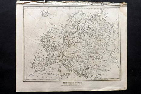
Sold2021Wilkes, John 1804 Map. Modern EuropeCopper Engraved Map Published 1796-1828 London for "Encyclopaedia Londinensis, or universal dictionary of arts, sciences and literature" by John Wilkes et al. Paper Size: 10.5 x 8.5 inch (27 x 22cm) VSee Sold Price
Sold2021Wilkes, John 1796 Map. Modern AfricaCopper Engraved Map Published 1796-1828 London for "Encyclopaedia Londinensis, or universal dictionary of arts, sciences and literature" by John Wilkes et al. Paper Size: 10.5 x 8.5 inch (27 x 22cm) GSee Sold Price
May 31Freeman's | Hindman[LINCOLN, Abraham (1809-1865)]. Tintype portrait of John Wilkes Booth.US$400
May 23Sloans & KenyonMOTOR ROUTES TO "REAL NEW ENGLAND INNS" MAP JOHN HELD JR, CIRCA 1930S. - Sight: 41 x 27 inches.US$750
Jun 06Weatherham Estate TreasuresAbraham Lincoln Bronze Bust Sculpture On Marble Base - Signed Original - 10lbsUS$400
May 30PropstoreJAWS 2 (1978) - Carl Gottlieb, Jeffrey Kramer, Ann Dusenberry and Others Autographed Japanese B2, 19£200
May 31Freeman's | Hindman[EARLY PHOTOGRAPHY]. A group of 4 stereoviews of an identified photographic wagon and studios, incl.US$200
May 24Kinghams AuctioneersJohn Speed (British, 1552-1629), map of Buckingham (1610), coloured engraving, published by George£40
May 24Kinghams AuctioneersJohn Speed (British, 1552-1629), map of Derbyshire (1610), coloured engraving, published by John£40
May 24Kinghams AuctioneersJohn Speed (British, 1552-1629), map of Herefordshire (1610), coloured engraving, published by John£40


![[LINCOLN, Abraham (1809-1865)]. Tintype portrait of John Wilkes Booth. (1 of 1)](https://p1.liveauctioneers.com/197/329785/177758539_1_x.jpg?height=282&quality=70&version=1715625218)


![[MAP]. SPEED, John. A New Mappe of the Romane Empire. 1676. (1 of 2)](https://p1.liveauctioneers.com/197/329395/177650541_1_x.jpg?height=282&quality=70&version=1715364962)


![[EARLY PHOTOGRAPHY]. A group of 4 stereoviews of an identified photographic wagon and studios, incl. (1 of 2)](https://p1.liveauctioneers.com/197/329785/177758511_1_x.jpg?height=282&quality=70&version=1715625218)


