Sold2018Oversized Industrial Commercial Oak Map Print CheOversized Industrial Commercial Oak Map Print Chest. Metal handles, panel sides. Antique.-- Dimensions: H: 65.5 inches: W: 63 inches: D: 25 inches ---See Sold Price
Sold2017German Moscovia Map PrintTitled "Mosvavw", hand colored, note on verso "Braun and Hogenburg, Cologne c. 1585 The earliest obtainable map or view of Moscow". Map, 15-1/2" x 21", framed 22-1/2" x 28"See Sold Price
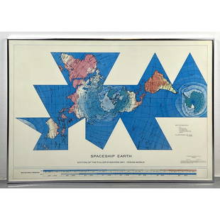
Sold2023Richard Buckminster Fuller Dymaxion World Map Print, 1980 FullerRichard Buckminster Fuller Dymaxion World Map Print, 1980 Fuller Dimensions: H: 22.5 inches: W: 34.5 inches --- -- We offer curbside delivery to NYC, Manhattan, Close Brooklyn, Hoboken about a week afSee Sold Price
Sold2020Norddeutscher Lloyd Bremen Ocean Liner Map PrintNorddeutscher Lloyd Bremen Ocean Liner Map Print framed under ship with steamships Munchen and Columbus. Measurements in inches: 45 x 33, Image: 39 x 27 Condition:Some wear to frame, print is clean ShSee Sold Price
Sold201819C Oak Map Print Paper Collector's Case CabinetUnited States,Late 19th Century Six long drawers with bin pulls on a molded base, used for holding works on paper including maps and blueprints. Oak 57" x 36" x 32", From an Exeter, Rhode Island estatSee Sold Price
Sold20193pc Stacking Industrial Metal Map Print Cabinet.3pc Stacking Industrial Metal Map Print Cabinet. Gray metal 5 drawer sections. Some drawers are lined. Silver chrome pulls. Marked HAMILTON.-- Dimensions: H: 49.75 inches: W: 41 inches: D: 29.5 inchesSee Sold Price
Sold2018Antique Multi Deep Drawer Cabinet. Map print caseAntique Multi Deep Drawer Cabinet. Map print case. Wood pulls. -- Dimensions: H: 29.5 inches: W: 35 inches: D: 35 inches ---See Sold Price
Sold2023Antique Map Print - Frederick de Witt - Map of The Kingdom of Denmark - EuropeTitle/Artist: Antique Map Print - Frederick de Witt - Map of The Kingdom of Denmark - Europe Date/Period: 1690 Material: Paper Dimensions: 56 cm x 67 cm Description: The Kingdom of Denmark, ComprisingSee Sold Price
Sold2023Antique Map Print - Europe - Spain and Portugal - Madrid - Lisbon - VaugondyTitle: Antique Map Print - Europe - Spain and Portugal - Madrid - Lisbon - Vaugondy Date/Period: 1806 Dimensions: 31,5 cm x 24 cm Material: Paper Additional Information: Original 1806 copper-engravedSee Sold Price
2023Antique Map Print - America - Map of New York - Pennsylvania - Jacques BellinTitle/Artist: Antique Map Print - America - Map of New York - Pennsylvania - Jacques Bellin Date: 1757 Material: Paper Dimensions: 37 cm x 25 cm Description: Carte de la Nouvelle Angleterre, NouvelleSee Sold Price
Sold2023Antique Map Print - America - Mexico - Brazil - California - Vaugondy - 1806Title: Antique Map Print - America - Mexico - Brazil - California - Vaugondy - 1806 Description: Original 1806 copper-engraved map by Robert de Vaugondy on the Mercator projection. Derived from "NouveSee Sold Price
Sold2023Antique Map Print - America - Revolutionary War Event the Battle of White PlainsTitle/Artist: Antique Map Print - America - Revolutionary War Event the Battle of White Plains Date: 1807 Material: Paper Dimensions: 45 cm x 28 cm Description: Antique uncolored map of the area alongSee Sold Price
Sold2023Antique Map Print - Europe - Map of Ancient Sicily - Italy - Philipp CluverTitle: Antique Map Print - Europe - Map of Ancient Sicily - Italy - Philipp Cluver Date: 1701 Material: Paper Dimensions: 15 cm x 13 cm Description: A detailed small map from ”Introductionis inSee Sold Price
Sold20191600s View of Mexico Hand Colored Map PrintNot sure when this was printed, but probably 18th or early 19th century. It has been in its current for about 100 years. Image size is 9 x 10.5, but is larger with border. Framed to 12.75 x 14.75. ImaSee Sold Price
Sold2023Antique Map Print - Five West Indies - North America - South America - 1701Title: Antique Map Print - Five West Indies - North America - South America - 1701 Date/Period: 1701 Dimensions: 15 cm x 13 cm Material: Paper Additional Information: A detailed small map from ”See Sold Price
Sold2022Antique Map Print - America - Map Of Virginia - Canals, Roads & Distances - USATitle: Antique Map Print - America - Map Of Virginia - Canals, Roads & Distances - USA Date/Period: 1846 Dimension: 44 cm x 34 cm Material: Paper Additional Information: A New Map Of Virginia With ItsSee Sold Price
Sold2023Antique Map Print - Map of Africa - Madagascar - Nil - Sahara - KilimanjaroTitle: Antique Map Print - Map of Africa - Madagascar - Nil - Sahara - Kilimanjaro Date/Period: 1701 Dimensions: 6” x 5” inches / 15 cm x 13 cm Material: Paper Additional Information: A deSee Sold Price
Sold2018"Mississippi River Plantations" framed map print."Mississippi River Plantations" framed map print with display light. 60" x 36".See Sold Price
Sold2023Antique Map Print - Asia - East Asia - Western Asia - North Asia - Central AsiaTitle: Antique Map Print - Asia - East Asia - Western Asia - North Asia - Central Asia Description: A detailed small map from ”Introductionis in universam Geographiam…” accessit P. BSee Sold Price
Sold2023Antique Map Print - Europe - Map of Silesia - Poland - Czech Republic - WroclawDescription: Map of Silesia. Silesia is a historical region of Central Europe that lies mostly within Poland, with small parts in the Czech Republic and Germany. Date: 17th Century Material: Paper DimSee Sold Price
Sold2023Decoy Makers Map PrintDecoy Makers of the Susquehanna Flats map print, Paul Shertz, signed and dated 1977, print 408/1200. framed, 30"h X 40"w.See Sold Price
Sold2019Astronomy Antique Map PrintCelestial Planisphere astronomy chart of stars, constellations, milky way. F.J. Huntington, Hartford, Connecticut: c. 1835 15 3/4" x 23 3/4".See Sold Price
Featured2024Jasper52USSR Caucasus. Georgia Azerbaydzhan Azerbaijan Armeniya Armenia. TIMES 1959 mapSee Sold Price
186 Lots AwayJasper52Europe by Joseph Wilson Lowry. Great Powers 1860 old antique map plan chartUS$20
2024Jasper52Europe Ethnographic map. Breton Basque Flemish Sudtyrol Languages. TIMES 1895See Sold Price
121 Lots AwayJasper52ANCIENT ROMAN EUROPE. Europa. Germania Gallia Hispania. ARROWSMITH 1828 mapUS$20
310 Lots AwayJasper52Svezia, Novergia, e Danimarca'. Scandinavia antique map by Claudio Buffier 1788US$40
7 days LeftJasper52The Island of Borneo by Edward Weller. Sarawak Sabah Brunei Kalimantan 1860 mapUS$50
284 Lots AwayJasper52Turkey in Europe. Balkans. Scarce edition w/o vignettes. TALLIS/RAPKIN 1855 mapUS$55
256 Lots AwayJasper52Germaniae / Germania by Bertius / Langenes. Germany & Central Europe 1603 mapUS$55
224 Lots AwayJasper52Turcicum Imperium by Bertius / Langenes. Ottoman Empire. Middle East 1603 mapUS$130
7 days LeftJasper52COLONIAL ASIA. East Indies &c. Inset Russian-Japanese War 1904/05 1914 old mapUS$10
216 Lots AwayJasper52Battle of Jutland. First of June 1916. First World War. 1923 old antique mapUS$20