Sold2022(FLORIDA PANHANDLE.) Joseph Frederick Wallet des Barres. The North East Shore of the Gulph of(FLORIDA PANHANDLE.) Joseph Frederick Wallet des Barres. The North East Shore of the Gulph of Mexico. Large engraved coastal chart of western Florida from Apalachicola to Mobile Bay. 4 sheets of "LVG"See Sold Price
Sold2023Large chart of Pacific & Indian Oceans 1813Heading: Author: Espinosa y Tello, Josef Title: Carta general para las navegaciones a la India Oriental por el Mar del Sur y el Grande Oceano que separa el Asia de la America Place Published: LondonSee Sold Price
Sold2023Xiamen West Port Hsia-Men Chiang Amoy Harbour ADMIRALTY chart 1904 (1953) mapTitle: Xiamen West Port Hsia-Men Chiang Amoy Harbour ADMIRALTY chart 1904 (1953) map Description: China - East Coast - Hsia-Men Chiang (Amoy Outer Harbour)' by Surveyed by Captain Morris H. Smyth, R.NSee Sold Price
Sold2016Large chart of the Azores 1755Heading: Author: Depot de la Marine Title: Carte Réduite des Isles Açores pour servir aux Vaisseaux du Roi Dréssée au Dépôt des Cartes, Plans, et Journeaux de la Marine... Place Published: [ParSee Sold Price
Sold2022Large chart of Strait of Magellan 1787Heading: (South America) Author: Schraembl, Franz Anton Title: Karte der Magellanischen Strasse von Herrn Don Iuan de la Cruz Cano y Olmedillo... Place Published: Wien Publisher:Jos. Gerstner DatSee Sold Price
Sold2017Rare French map of Alaska Panhandle 1896Heading: (North America - Pacific Northwest) Author: Title: Amérique du Nord - Côte Ouest. De Dixon Entrance à Cross Sound d'après les Cartes anglaises et américaines Place Published: [Paris, FrSee Sold Price
Sold2019Large 1904 Coca-Cola Ink Blotter.This is a wonderfully strong example of what is a difficult blotter to find. The blotter exhibits no wear whatsoever with strong remaining blue tones and shades. Condition: 9.9, Near Mint+. DimensionsSee Sold Price
Sold2021George Eldridge, Large Chart of Chesapeake Bay 1868George Eldridge / G. W. Boynton, Sc., ELDRIDGEÕS CHART OF CHESAPEAKE BAY, JAMES, YORK, RAPPAHANNOCK AND POTOMAC RIVERS. Compiled from the latest surveys by GEORGE ELDRIDGE, HYDROGRAPHER. Boston: S. TSee Sold Price
Sold2019Verbeek 1905 Large Chart. Topography of Java, IndonesiaLarge Folio Lithograph Published 1905, Batavia for "Geologische beschrijving van Ambon" by Rogier Diederik Marius Verbeek. Centre fold as issued. Paper Size: 26 x 16.5 inch (66 x 42cm) Several marginSee Sold Price
Sold2023Sitka, Alaska, Dated 1904 Totem Pole 23.5 INSitka, Alaska (1904) 360 degree 23.5 in. tall wood totem pole. Depicts four (4) figures. Rubbed with paint wear and 3 hands / arms broken off. Mounted to a stand that measures 4 in. x 4 in. x .5 in. PSee Sold Price
Sold2018Iceland.- Bellin (Jacques Nicolas) Carte Reduite deIceland.- Bellin (Jacques Nicolas) Carte Reduite de l'Islande et des Mers qui en sont Voisines ..., large chart of Iceland with the Faroe Islands in the lower right corner, extensive title and descripSee Sold Price
Sold2022Martha’s Vineyard, 1855 Coastal SurveyPainstakingly hand-colored large chart showing Martha’s Vineyard and the Falmouth area of Cape Cod. Minutely detailed with hundreds of soundings shown. “Preliminary Chart of Muskeget ChannSee Sold Price
Sold2022Nystrom Anatomical Roll Out Chart Muscles 1918,ScienceNystrom Anatomical Roll Out Chart Muscles 1918. Marked Copyright 1918, A.J. Nystrom & Co Publishers, Chicago, American Edition, Chart No. 2, large chart shows the muscles of the human body. FascinatinSee Sold Price
Sold2021VINTAGE SWITZERLAND AND ALASKA PATCHESVINTAGE SWITZERLAND AND ALASKA PATCHES 2 large Alaska patches and brass bookmark, and 2 small Switzerland ski patches. 5 1/2" x 3 1/2" <See Sold Price
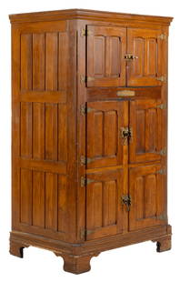
Sold2023Large Antique "Alaska" Ice BoxLarge antique three tier ice box, wooden paneled case, six hinged doors that open to a lined interior, brass hardware, marked "Alaska" (Muskegon, Michigan) height 81.5 in. x width 46.5 in. xSee Sold Price
Sold2023Large 1876 chart of Long Island Sound from Newport to New York. Compiled by George Eldridge, publishLarge 1876 chart of Long Island Sound from Newport to New York. Compiled by George Eldridge, published by S. Thaxter & Son, Boston. Nautical chart with notable coastal towns and landmarks. Canvas backSee Sold Price
Sold20231770 Large Printed Chart of the Troops of FranceColonial America 1770 Dated, "Carte Des Troupes De France, Sur Le Pied Des Ordonnances 1770" ("Chart of the Troops of France, Based on the Ordinances of 1770" 1770-Dated, Pre-Revolutionary War AmericaSee Sold Price
Sold2019Chastenet-Puységur: Large Hispaniola Chart, 1787Cartographer: Chastenet-Puységur/Dépôt de la Marine Place/Date: Paris / 1787 Size: 37 1/4" x 23 1/2" Condition: beautifully colored; split in upper margin and border and along bottom centerfold expSee Sold Price
Sold2016John Muir Travels in Alaska Large Paper EditionHeading: Author: Muir, John Title: Travels in Alaska - Large-paper edition Place Published: Boston Publisher:Houghton Mifflin Company Date Published: 1915 Description: ix, [4],See Sold Price
Sold20181740 Large Folding Chart Western AtlanticA New Map of Chart of the Western or Atlantic Ocean with part of Europe Africa and America: Shewing the Course of the Galleons, Flota, and C to and from the West Indies, London, printed for E. Cave atSee Sold Price
Sold2019Chatelain, Zacharie 1708 Large Genealogy Chart"Carte Genealogique de la Maison de Brunsuick-Lunebourg, ses differentes branches ses Titres et ses Pretentions" Copper Plate Published 1705-20, Amsterdam for "Atlas Historique, Ou Nouvelle IntroductiSee Sold Price
Sold2019Chatelain, Zacharie 1708 Large Genealogy Chart"Trophee Eleve a la Gloire des Premiers Heros de la Liberte Germanique" Copper Plate Published 1705-20, Amsterdam for "Atlas Historique, Ou Nouvelle Introduction A L'Histoire" by Zacharie Chatelain. PSee Sold Price
Sold2023Perry, Matthew 1856 Large Map. Chart of the World. Track of the U.S Steam Ships"Chart of the World showing the Track of the U. S. Steam Frigates Mississippi, Susquehanna, and Powhatan" Large Folio Lithograph Map Published 1856, Washington for "Narrative of the Expedition of an ASee Sold Price
Sold2019Chatelain, Zacharie 1708 Large Genealogy Chart"Genealogie de la Maison d'Anhalt, ses differentes Branches, ses Titres, ses Armes, et ses Alliances" Copper Plate Published 1705-20, Amsterdam for "Atlas Historique, Ou Nouvelle Introduction A L'HistSee Sold Price
May 10Crescent City Auction GalleryAfter Emile Galle (French, 1846-1904), Large Style Scenic Cameo Vase, 20th c., H.- 15 in., Dia.- 7 1$400
1 day LeftGOLDFIELD AUCTIONEmile GALLE (1846-1904) Large acid-etched multi-layered glass vase, wisteria design, signed.€800
5 days LeftJasper521699 Moll World Map with Cowley's Voyages -- Nouvelle Carte du Monde Suivant l'idee de Mercator ou$240
5 days LeftJasper521850 Sacramento and San Joaquin Rivers Chart -- Chart of Suisun & Vallejo Bays with the Confluence$200
6 days LeftJasper52Hawaiian–Emperor seamount chain Midway-Kauai ADMIRALTY chart 1950 (1955) map$140
6 days LeftJasper52South Pacific Ocean. French Polynesia Cook Islands. US Navy sea chart 1895 map$130
6 days LeftJasper52Marshall Islands North Pacific Ocean Micronesia ADMIRALTY chart 1891 (1953) map$120
6 days LeftJasper52Caroline Islands Palau Malakal Ngulu Angaur. ADMIRALTY sea chart 1928 (1956) map$120
6 days LeftJasper52South west Pacific Ocean Melanesia Polynesia ADMIRALTY sea chart 1875 (1968) map$120
5 days LeftJasper52Gunnar Nylund for Rörstrand. Large ceramic vase in a classic form. Glaze in light brown tones.$380


![John Muir Travels in Alaska Large Paper Edition: Heading: Author: Muir, John Title: Travels in Alaska - Large-paper edition Place Published: Boston Publisher:Houghton Mifflin Company Date Published: 1915 Description: ix, [4],](https://p1.liveauctioneers.com/642/86438/44449367_1_x.jpg?height=310&quality=70&version=1458591928)


