Sold20191827 American Coast Pilot by Blunt MAPS Nautical Guide1827 American Coast Pilot by Blunt MAPS Nautical Guide Navigation Lighthouses Harbors Originally printed in 1796 (Adams), Edmund Blunt’s ‘American Coast Pilot’ was one of the earliest American wSee Sold Price
Sold20201817 American Coast Pilot by Blunt Nautical MAPS1817 American Coast Pilot by Blunt Nautical MAPS Navigation Lighthouses Harbors Originally printed in 1796 (Adams), Edmund Blunt’s ‘American Coast Pilot’ was one of the earliest American works oSee Sold Price
Sold2023Maps of North/South Carolina, Charleston HarborMap of North and South Carolina engraved and printed by Ferrier Sears & Co., published by J.T. Hinton, Simpkin & Marshall, 1832..Charleston Harbor Map, engraved for The American Coast Pilot, 14th editSee Sold Price
Sold2018Book Titled The American Coast Pilot 1847By Edmund M. Blunt, including many maps. Provenance: The library of the family Cateau van Rosevelt.See Sold Price
Sold20241897 Scott's New Coast Pilot For The LakesA fifth edition Scott's New Coast Pilot for the Lakes 1896 by George Scott, revised to 1897, with 289 pages with maps, diagrams, and illustrations. The hardcover book has a cloth spine and shows moderSee Sold Price
Sold2016EDMUND MARCH BLUNT (AMERICAN, 1770-1862) MAP OF THEEDMUND MARCH BLUNT (AMERICAN, 1770-1862) MAP OF THE CHESAPEAKE BAY, engraving on laid paper, from Blunt's "The American Coast Pilot", published in New York. Housed under glass in a modern frame. CircaSee Sold Price
Sold20231806 hand colored map titled "Ocracock Bar including Shell Castle" from pgs of American Coast PilotA hand colored map of "Ocracock Bar including Shell Castle", a page or partial page most likely taken from the 5th edition of "The American Coast Pilot Containing the Courses and Distances between theSee Sold Price
Sold2021(3) 19TH C. MARITIME HANDBOOKSIncluding: Blunt's American Coast Pilot, 15th edition, May 1847, in sailcloth wrap, well-used but complete, scarce in any condition; PLUS ibid 16th edition, with fold-out map, 1850, full calf; PLUS BlSee Sold Price
Sold20201746 Map by Child of Calbar River in Nigeria -- AnTitle: 1746 Map by Child of Calbar River in Nigeria -- An accurate Map, of Kalbar River, (Commonly called Kalabar or Rio Real) and the Adjacent Coast, drawn on the spot by several Pilots 1699 CartograSee Sold Price
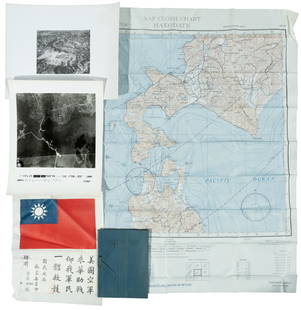
Sold2022WWII fighter pilot maps and kitHeading: (World War II) Author: Title: Fighter pilot materials from World War II Place Published: Publisher: Date Published: c.1943-1945 Description: 1 set. Includes:See Sold Price
Sold2020Coast Pilot of California, Oregon, and WashingtonHeading: Author: Davidson, George Title: Pacific Coast. Coast Pilot of California, Oregon, and Washington Territory Place Published: Washington Publisher:Government Printing Office Date PublisheSee Sold Price
Sold2022The Atlantic Coast Pilot (1878)A copy of The Atlantic Coast Pilot. Boston Bay to New York. By the United States Coast Survey. (Washington, D.C., 1878). With many engraved folding plates of coastal profiles and harbor charts.See Sold Price
Sold2021COAST PILOT BOOKCOAST PILOT BOOKTitled on cover Stebbins' Illustrated Coast Pilot. Fully titled The Illustrated Coast Pilot. With Sailing Directions. The Atlantic and Gulf Coasts of the United States, Including BaysSee Sold Price
Sold2022[ALASKA]. Pacific Coast Pilot. Coasts and Islands of Alaska...[ALASKA]. Pacific Coast Pilot. Coasts and Islands of Alaska. Second Series. Washington: Government Printing Office, 1879. 4to (287 x 225 mm). Illustrated with 1 photographic plate, 7 double-page fold-See Sold Price
Sold2016Coast Pilot of Alaska 1883Heading: Author: [Dall, William H.] Title: Pacific Coast Pilot: Alaska. Part I [Dixon Entrance to Yakutat Bay with the Inland Passage] Place Published: Washington Publisher:Government Printing OfficeSee Sold Price
Sold2022Cold War US Military Defense Aviation Pilot Maps LotCold War US Military Defense Aviation Pilot Maps Lot. Lot of 5 maps. You will receive the following maps: Global Navigation and Planning Chart GNC 26N, GNC 2, GNC 4, GNC 6 and GNC 8. Prepared and publSee Sold Price
Sold202118th Century Florida Louisiana Coast Map - JefferysCarte de la Floride occidentale et Louisiane. La peninsule et golfe de la Floride ou canal de Bahama avec les isles de Bahama. Contributors - Le Rouge, Georges-Louis, Jefferys, Thomas, -1777. PrintedSee Sold Price
Sold2021Silk pilot map, escape and evasion map, 1940s, R.A.A.FSilk pilot map, escape and evasion map, 1940s, Royal Australian Air Force (R.A.A.F.), map is 21.75" by 31.75", framedSee Sold Price
Sold20191838 Greece Aegean Sea and West Turkish Coast MapCarte de la Crece Ancienne par Delamanche 1838See Sold Price
Sold2023The Caribbean & Coast Map Company Map, Hurricane Data 1946Depicts a tracking record of hurricanes in the gulf and Caribbean from 1924 to 1946. Publishing stamp by "The Caribbean & Coast Map Company" located on bottom. Issued: 1946 Dimensions: 21"See Sold Price
Sold2023THREE ITEMS OF MAINE INTEREST: "LAWS OF THE STATEOF MAINE, JUNE 1820", "ATLANTIC LOCAL COAST PILOT: FRENCHMAN'S BAY TO ISLE AU HAUT, 1879" AND "MOUNT DESERT VIEWS: COLLECTION OF ALBERTYPES, BOSTON". 1) The original book of the Laws of the State of MSee Sold Price
Sold2022FIVE LEATHERBOUND BOOKS OF MARINE INTEREST 19th CenturyFIVE LEATHERBOUND BOOKS OF MARINE INTEREST19th Century1) Shipmaster’s Assistant & Commercial Digest by Joseph Blunt. N.Y.: E. & G.W. Blunt, 1857.2-3) Two copies of The American Coast Pilot by EdSee Sold Price
Sold2016Sailing directions for Alaska in 1891Heading: (Alaska) Author: Nichols, Henry E., compiler Title: Pacific Coast Pilot: Alaska. Part I, Dixon Entrance to Yakutat Bay with Inland Passage from Strait of Fuca to Dixon Entrance Place PublisheSee Sold Price
Sold2016Coast Survey report on Alaska weather 1879Heading: Author: Dall, William H. Title: Pacific Coast Pilot Coasts and Islands of Alaska, Second Series - Coast Pilot of Alaska Appendix 1 Meteorology Place Published: Washington Publisher:GovernmenSee Sold Price
4 days LeftJasper521852 Owen Geological Maps of the Pigeon River Minnesota -- (1) Geological Map Coast View and Section$45
7 days LeftHolabird Western Americana CollectionsUS Coast Survey Maps Pt. Pinos & Conceptions 1851 (2) [179998]$100
5 days LeftJasper52WEST AFRICA. British Cameroons & Togoland mandates. Gold Coast Nigeria 1947 map$20
5 days LeftJasper52Suite de la Coste de Guinée'. Ghana Togo Benin coast. BELLIN/SCHLEY 1748 map$30
5 days LeftJasper52Partie de la Coste de Guinée' Sierra Leone Liberia coast BELLIN/SCHLEY 1747 map$35
5 days LeftJasper52Partie de la Coste de Guinée'. Sierra Leone & Liberia coast. BELLIN 1747 map$40
5 days LeftJasper52WEST AFRICA I Explorers' routes Senegal Ashanti Ivory Gold Coast. SDUK 1851 map$40
Featured5 days LeftJasper52Coste Occidentale d’Afrique…' Namibia South Africa Angola coast BELLIN 1746 map$45
Featured5 days LeftJasper52Suite de la Coste de Guinée'. Ghana Togo Benin coast. Whidah. BELLIN 1747 map$30
5 days LeftJasper52Partie Occidentale de l'Ancien Continent… W Africa Macaronesia. BONNE 1780 map$30
4 days LeftJasper52Title/Content of Map: Jamaica: Port Mosquito Coast, by Ferrer, 1818 Date Printed: 1818$55
5 days LeftJasper52Partie Occidentale de l’Afrique. West Africa coast Canary islands BONNE 1788 map$15
5 days LeftJasper52Afrique. Côte Déserte #48. Skeleton Coast. Namibia. VANDERMAELEN 1827 old map$100
5 days LeftJasper52Coste Orientale d’Afrique…' South Africa. Mozambique channel. BELLIN 1746 map$25
5 days LeftJasper52Coste Orientale d’Afrique'. South Africa Mozambique BELLIN/SCHLEY 1747 map$25
5 days LeftJasper52Coste Occidentale d’Afrique…' Arguin Bay Cap Blanc Mauritania. BELLIN 1746 map$30
5 days LeftJasper52Coste Occidentale d’Afrique'. Bay of Arguin, Mauritania. BELLIN/SCHLEY 1747 map$30
5 days LeftJasper52Coste Occidentale d’Afrique…' West Africa. Gulf of Guinea. BELLIN 1746 map$55
Featured5 days LeftJasper52Coste Orientale d’Afrique…' East Africa Kenya Tanzania Somalia. BELLIN 1746 map$80
5 days LeftJasper52Côte occidentale de l'Afrique. W Africa.Senegal Gambia rivers.D’ANVILLE 1751 map$85


![[ALASKA]. Pacific Coast Pilot. Coasts and Islands of Alaska...: [ALASKA]. Pacific Coast Pilot. Coasts and Islands of Alaska. Second Series. Washington: Government Printing Office, 1879. 4to (287 x 225 mm). Illustrated with 1 photographic plate, 7 double-page fold-](https://p1.liveauctioneers.com/928/265343/138522473_1_x.jpg?height=310&quality=70&version=1666130009)
![Coast Pilot of Alaska 1883: Heading: Author: [Dall, William H.] Title: Pacific Coast Pilot: Alaska. Part I [Dixon Entrance to Yakutat Bay with the Inland Passage] Place Published: Washington Publisher:Government Printing Office](https://p1.liveauctioneers.com/642/91039/46504421_1_x.jpg?height=310&quality=70&version=1468342277)


![US Coast Survey Maps Pt. Pinos & Conceptions 1851 (2) [179998] (1 of 1)](https://p1.liveauctioneers.com/2699/331495/178785796_1_x.jpg?height=282&quality=70&version=1717094933)


