Sold2024Churchill - 3 Maps pertaining to the AmericasIncluded in this lot: Terra Firma, Guiana, and the Antilles Islands (West Indies) (Part of South America) Map of North America with New France, Florida, Louisiana, Great Lakes, Canada, & New England MSee Sold Price
Sold2017Five Lithograph Maps of the Lower MississippiFive U.S. Army Corps of Engineers Colored Lithograph Maps of the Lower Mississippi including two 1890s examples that chart the river improvements and levee lines from Lake Providence in Louisiana to tSee Sold Price
Sold2022[MAPPING REFERENCE] MISSISSIPPI. LOT OF 2 VOLUMESMAPPING REFERENCE. A lot of 2 volumes sold together, both both generally fine condition. Including:Lemmon, Alfred E.,etc. [editors]. CHARTING LOUISIANA: FIVE HUNDRED YEARS OF MAPS. The Historic New OrSee Sold Price
Sold2020Charting LouisianaFive Hundred Years of Maps, The Historic New Orleans Collection 2003. From the private collection of Roulhac Toledano, noted author, historian, artist, and tirelesspromoter of Charlottesville.All saleSee Sold Price
Sold2022Five Maps of NantucketFour of the island and one of Main Street, including one by Tony Sarg (German, 1880-1942) Frames loose. Sizes from 17"h x 20"w to 23"h x 34"w overallSee Sold Price
Sold2019Five Maps by Abraham Ortelius (1527-1598), Three "LaFive Maps by Abraham Ortelius (1527-1598), Three "La Florida Aue Tore Hieron Chiaues; Two Guastecan Reg," 1583, H.- 8 3/4 in., W.- 11 1/2 in., and H.- 17 1/2 in., W.- 11 in. (5 Pcs.)See Sold Price
Sold20161760 French + Indian War Map Louisiana + FloridaHistoric Maps French & Indian War Era Map of Louisiana & Florida c. 1760 French & Indian War Era, Historic Map Titled, “Carte de la Louisiane, et de la Floride. Par M. Bonne, Ingenieur-Hydrographe dSee Sold Price
Sold2018Four Small Antique Maps Pertaining to Cyprusas follows: Hogenberg, F. and Braun G. Famaugusta, copperplate engraving (Cologne, late 16th century) sheet, 8.75 x 14 in., giving a birds-eye view of the Cypriot port city; Mercator, Hondius, JanssonSee Sold Price
Sold2023[PICTORIAL MAPS]. Five maps. Includes: GREEN, Mildred C. A ...[PICTORIAL MAPS]. Five maps. Includes: GREEN, Mildred C. A Romance Map of New Jersey. 1935. Buffalo: Whitney-Graham Company. Inc. Colorful pictorial map with small illustrations and explanations of NeSee Sold Price
Sold[MAPS - LOUISIANA - WAR OF 1812]. Maps of Louisiana, incl. Battle of New Orleans battle site map.[MAPS - LOUISIANA - WAR OF 1812]. Maps of Louisiana, incl. Battle of New Orleans battle site map. Plan of the Operations of the British & American Forces below New Orleans, on the 8th of January,See Sold Price
Sold20192 Hand Colored Maps - Louisiana - MississippiTwo Gray's Atlas Maps on one sheet - Louisiana & Mississippi Depicts railroad lines, common roads, canals, topography, etc. Maps are on each side of one sheet. A bSee Sold Price
Sold2021Asia.- Lizars (W.) and others. Five maps of China,Asia.- Lizars (W.) and others. Five maps of China, including Lizars' map of the mainland, Robert Wilkinson's 'China, Contains 15 Subject Provinces', 2 maps of mainlaind China by Fullarton & Co., and aSee Sold Price
Sold2022Pair 19th C Framed Color Maps, Louisiana & New OrleansPair of 19th C Framed Color Maps, Louisiana & New Orleans. A set of framed maps; a state map of Louisiana from 1848 and a city plan of New Orleans from 1884. Both are published by S. Augustus MitchellSee Sold Price
Sold2019Herman Moll, Five Maps of AsiaHeading: Author: Moll, Herman Title: Five maps of Asia Place Published: London Publisher:Printed for Tim. Childe Date Published: 1701 Description: Five maps. Each sheet appSee Sold Price
Sold2023Group of Five MapsGroup of Five Maps, to include a new map of ancient Greece Thrace by William; Sweden; East Nottingham; Ireland; along with South Eastern Greece Attica Megorica Corinthiaca engraved map; largest 15" xSee Sold Price
Sold2017Four 19th Century Maps Pertaining to the Western Unitedas follows: Geological Map of a Part of the State of California Explored in 1855 by Lieut. R. S. Williamson U.S. Top Engr (Washington: War Department, 1856); color-coded (24.5 x 19.25 in.) (Some edgeSee Sold Price
Sold2021A GROUP OF TWO MAPS, LOUISIANA AND NEW ORLEANS, EARLYA GROUP OF TWO MAPS, LOUISIANA AND NEW ORLEANS, EARLY 20TH CENTURY, comprising, "The RAND-McNALLY New Commercial Atlas Map of New Orleans," 1912, page 238, from Commercial Atlas Map of America, a reisSee Sold Price
Sold2019Five Maps: consisting of two copies of Johnson & Ward,Five Maps: consisting of two copies of Johnson & Ward, "Lower and Upper Canada," 1860-1863, hand colored, H.- 26 1/2 in., W.- 18 1/8 in.; together with two copies of Johnson & Ward, "Lower Canada & NeSee Sold Price
Sold2019Five Maps by the Hydrographic Office U. S. Navy,Five Maps by the Hydrographic Office U. S. Navy, consisting of "England West Coast- Start Point to Needles Channel," 1933, H. -28 3/4 in., W. - 36 1/2 in.; "England East Coast- River Thames Entrance,See Sold Price
Sold2019Five Maps by the Hydrographic Office U. S. Navy,Five Maps by the Hydrographic Office U. S. Navy, consisting of "Pertuis D'Antioche and Approaches to La Rochelle and Rochefort," 1922, H. - 29 3/4 in., W. - 42 in.; "France North Coast- Port of CherboSee Sold Price
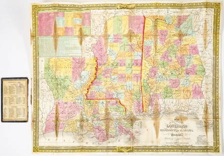
Sold20241835 Mitchell Map Louisiana, Mississippi, Alabama1835 Mitchell Map of Louisiana, Mississippi and Alabama -- Map of the States of Louisiana, Mississippi & Alabama. Cartographer: S Mitchell, 1835, Philadelphia. Map Dimension (in.): 18.25 x 22.625 inchSee Sold Price
Sold20171860 MAP LOUISIANA, MISSISSIPPI, ARKANSASFramed hand colored 1860 map, 'Map of Louisiana, Mississippi and Arkansas" by Augustus Mitchell (American, 1790-1868), sight: 14"h, 11.25"w, overall: 21.5"h, 18.75"w, 4.25lbs Start Price: $100.00See Sold Price
Sold2022c 1760 Northern Colonies French + Indian War MapHistoric Maps Louisiana & Florida French & Indian War Era Map c. 1760 c. 1760 French & Indian War Era, Hand-Colored Map of Pennsylvania and New England titled, "Carte de la Partie Nord, Des Etats UnisSee Sold Price
Sold2020Grp: 5 Maps of Africa Jaillot DelisleGroup of five maps of Africa. Includes Hubert Jaillot (1632-1712), "L'Afrique divisee suivant l'estendue de ses principales parties, ou sont distingues les uns des autres les Empires, Monarchies, RoyaSee Sold Price
5 days LeftTrillium Antique Prints & Rare BooksDe L'Isle - Map of Louisiana and the Course of the Mississippi (Eastern America) (First Appearance$240(2 bids)
1 day LeftJasper521874 Mitchell Map of Texas, Louisiana and Arkansas -- Map of Louisiana, Texas, Arkansas$65
1 day LeftJasper521874 Mitchell Map of Mississippi, Louisiana and Arkansas -- County Map of the States of Arkansas$40
2 days LeftJasper52Map of Narnia & the surrounding countries by Pauline Baynes. 50x76cm poster 1972$500
11 hrs LeftRapid Estate Liquidators and Auction Gallery1870's Louisiana Baby Bond $5 Five Dollars Obsolete Currency High Grade$25
4 days LeftBrunk AuctionsFive Former MESDA English Delft "Merry Man" Plates, with One Made To Match$1,000
1 day LeftJasper521799 Cary Map of Northwest Italy -- A New Map of Piedmont, the Duchies of Savoy and Milan; and the$70
1 day LeftJasper521787 Bonne Map of Martinique and Guadaloupe -- Isle de la Martinique [on sheet with] Isles de la$65


![[MAPPING REFERENCE] MISSISSIPPI. LOT OF 2 VOLUMES: MAPPING REFERENCE. A lot of 2 volumes sold together, both both generally fine condition. Including:Lemmon, Alfred E.,etc. [editors]. CHARTING LOUISIANA: FIVE HUNDRED YEARS OF MAPS. The Historic New Or](https://p1.liveauctioneers.com/8124/269534/141083180_1_x.jpg?height=310&quality=70&version=1669081764)


![[PICTORIAL MAPS]. Five maps. Includes: GREEN, Mildred C. A ...: [PICTORIAL MAPS]. Five maps. Includes: GREEN, Mildred C. A Romance Map of New Jersey. 1935. Buffalo: Whitney-Graham Company. Inc. Colorful pictorial map with small illustrations and explanations of Ne](https://p1.liveauctioneers.com/928/305275/163151900_1_x.jpg?height=310&quality=70&version=1697054833)
![[MAPS - LOUISIANA - WAR OF 1812]. Maps of Louisiana, incl. Battle of New Orleans battle site map.: [MAPS - LOUISIANA - WAR OF 1812]. Maps of Louisiana, incl. Battle of New Orleans battle site map. Plan of the Operations of the British & American Forces below New Orleans, on the 8th of January,](https://p1.liveauctioneers.com/197/333931/180433328_1_x.jpg?height=310&quality=70&version=1719251353)


![[MAPPING REFERENCE] MISSISSIPPI. LOT OF 2 VOLUMES (1 of 3)](https://p1.liveauctioneers.com/8124/343618/186530162_1_x.jpg?height=282&quality=70&version=1726178725)


![1787 Bonne Map of Martinique and Guadaloupe -- Isle de la Martinique [on sheet with] Isles de la (1 of 1)](https://p1.liveauctioneers.com/5584/343693/186665651_1_x.jpg?height=282&quality=70&version=1726603887)