Sold2023Map: An 18thC engraved strip / road map after John Owen and Emanuel Bowen, showing the road fromMap: An 18thC engraved strip / road map after John Owen and Emanuel Bowen, showing the road from London to Rochester via Deptford, Crayford and Dartford. Approx. 7 1/4" x 4 3/4"See Sold Price
Sold2018Bowen: Antique Map of Kent, 1756Title/Content of Map: Kent Date Printed: 1756 Cartographer: BOWEN, EMANUEL Size (inches): 14.3x10.3 "divided into its lathes containing the cities, burough & market towns, with the roads and distancesSee Sold Price
Sold2019Emmanuel Bowen, Map of GeorgiaEmmanuel Bowen, Map of Georgia, Emmanuel Bowen (British, 1694-1767), "A New Map of Georgia with part of Carolina, Florida and Louisiana", hand-colored lithograph, published in "Complete Collection ofSee Sold Price
Sold2020Bowen, Emmanuel 1760 Hand Col Map of Staffordshire, UKHand Colored Copper Engraved Map Published 1755-65 by W. Owen, London for "The General Magazine of Arts & Sciences" Edited by Benjamin Owen. Map by Emmanuel Bowen. Paper Size: 8.5 x 5 inch (22 x 13cm)See Sold Price
Sold2020Bowen, Emmanuel 1767 Hand Col Map of Staffordshire, UKHand Colored Copper Engraved Map Published 1767, London for "Atlas Anglicanus" by Thomas and Emmanuel Bowen. Paper Size: 14 x 9.5 inch (36 x 24cm) Very fragile paper. Heavy browning/toning. Tiny chipsSee Sold Price
Sold2018UK Road Maps C1750-1785 Lot of 16. Paterson, BowenGood Lot of 16 Copper Engraved Road Maps. 15 by Paterson, Published 1785 by Carrington Bowles, London for "Paterson's British Itinerary" First Edition by Captain Daniel Paterson. Together with one hanSee Sold Price
Sold20221736 Map - THE ROAD FROM LONDON TO DOVER IN KENTHistoric Maps THE ROAD FROM LONDON TO DOVER IN KENT 1736 Hand-Colored Engraved Copper Plate Map titled, "THE ROAD FROM LONDON TO DOVER IN KENT", measuring 7.75" x 5.25", from Britannia Depicta, LondonSee Sold Price
Sold2022Bowen, Thomas 1782 Large Map of England & Wales"A New & Most Accurate Map of the Roads of England and Wales" Copper Engraved Map Published 1779-82 by J. Cooke, London for "The Modern Universal British Traveller or, a New, Complete, and Accurate toSee Sold Price
Sold2017[Maps] Britannia Depicta, 1720Bowen, Emanuel. BRITANNIA DEPICTA OR OGILBY IMPROV'D; BEING A CORRECT COPPY OF MR. OGILBY'S ACTUAL SURVEY OF ALL YE DIRECT & PRINCIPAL CROSS ROADS IN ENGLAND AND WALES. London: Tho. Bowles, 1720. 8vo.See Sold Price
Sold2018London-Southwark-New Cross-Eltham-Addington-DittonTITLE/CONTENT OF MAP: '[London-Southwark-New Cross-Eltham-Farningham-Wrotham-Addington-Ditton]' The Road from London to Hith in com. Kent: plate 2 of 3: Southwark-New Cross-Farningham-Wrotham-Ditton DSee Sold Price
Sold2024Keith Haring Artwork Signed on a Shell Oil New York Road Map 18 in. x 24 in.Keith Haring Artwork Signed on a Shell Oil New York Road Map 18 in. x 24 in. size: 18 x 42 open - rippingSee Sold Price
Sold2023Emanuel Bowen Map North & South Carolina, Georgia[Emanuel Bowen Map of North & South Carolina and Georgia] , "A New & Accurate Map of the Provinces of North & South Carolina Georgia & c. Drawn from late Surveys and regulated by Astron Observat. By ESee Sold Price
Sold2022Bowen - Map of North and South CarolinaEmanuel Bowen (1694-1767), A New & Accurate Map of the Provinces of North & South Carolina, Georgia, & C., London, circa 1747, in two sheets, engraving on laid paper, with title cartouche in the upperSee Sold Price
Sold2017Two Emanuel Bowen Maps Showing the East Coastfrom A Complete System of Geography (London, 1747), copperplate engravings with outline color as follows: A New and Accurate Map of New Jersey, Pennsylvania, New York and New England and A New & AccurSee Sold Price
Sold2017Emanuel Bowen, map Eastern SeaboardEmanuel Bowen, map Eastern Seaboard, Emanuel Bowen (British, 1694-1767), "A New and Accurate Map of New Jersey, Pennsylvania, New York, and New England", c. 1744, from Maryland to Nova Scotia, hand-coSee Sold Price
Sold2022HUSKY GASOLINE SERVICE STATION MAP DISPLAY W/ HUSKY ROAD MAPS.SST. An excellent and complete example of this Circa 1950's Service Station Road Map Display from Husky showing a Tin Husky Sign at the face and complete with Maps. CONDITION: Display is in overall exSee Sold Price
Sold2022New road map of the city of Paris 1839 Rosselin editeur engravingNouveau plan routier de la ville de Paris, Guide exacte de cette capitale : en 12 arrondissemens avec leurs mairies et en 48 quartiers, 1839V. ROSSELIN (19th century), print editor, Paris, EstablishedSee Sold Price
Sold2022British road maps.- Ogilby (John) The Roads fromNO RESERVE British road maps.- Ogilby (John) The Roads from Chelmsford in Essex to St. Edmonds-Bury in Suffolk & Saffron-Walden in Essex, strip road map, engraving with hand-colouring, on thin laid paSee Sold Price
Sold2022Emanuel Bowen Map USA Eastern Seaboard 1740s New YorkEmanuel Bowen, map of United States Eastern Seaboard, Emanuel Bowen (British, 1694-1767), "A New and Accurate Map of New Jersey, Pennsylvania, New York, and New England", c. 1744, from Maryland to NovSee Sold Price
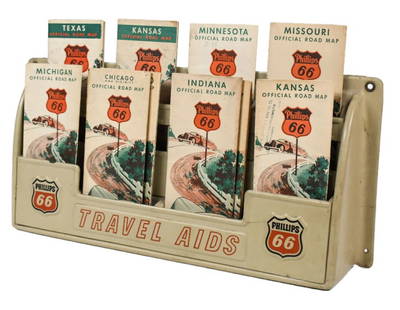
Sold2023Vintage Phillips 66 Road Map Embossed Display RackVintage Phillips 66 embossed plastic road map display rack full with original 1930s Phillips 66 maps. Rack has discoloration, some expected chips/ cracks, and wear from use and age. Displays well withSee Sold Price
Sold201718thc Map: United States of America, Wilkes, 1797Framed antique map, United States of America, Published London 1797 by J. Wilkes. Engraved by Neele, 352 Strand, London. Hand colored, the map shows the United States in the Decade after the AmericanSee Sold Price
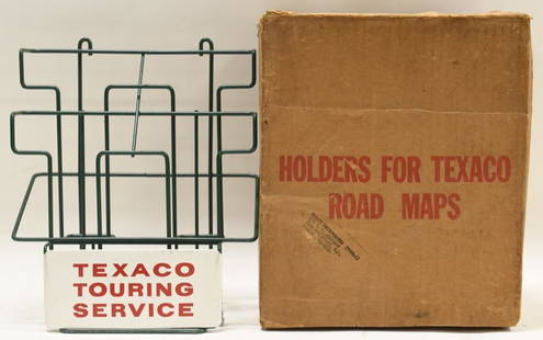
Sold2021Vintage NOS Texaco Road Map Metal Display RackVintage new old stock Texaco road map metal display rack in original box. Nice condition with light wear from age and storage. Display rack measures approximately 10-1/2" tall by 9" across.See Sold Price
Sold2020Road map of Southern California 1918Heading: (California) Author: Title: Automobile Road Map of Los Angeles, Orange, Riverside and San Bernardino Counties Place Published: Los Angeles Publisher:Security Trust & Savings Bank Date PSee Sold Price
2 days LeftJasper52An Accurate Map of the County of Kent Divided into its Lathes… by E Bowen 1762$320
Featured1 day LeftJasper521761 NEW DICTIONARY OF TRADE & COMMERCE R. ROLT antique FOLIO ILLUSTRATED w/MAPS$440
2 days LeftJasper52London Greenwich Chatham Sittingbourne Canterbury Dover OGILBY road map #28 1675$300
2 days LeftJasper52A Topographical plan of Manchester & Salford 92x105cm LAURENT/STOCKDALE 1793 map$480(1 bid)
2 days LeftJasper52The South Pole with the track of HMS Resolution. Cook. Antarctic. BOWEN 1776 map$320
Oct 12JM Hobby Supply and Railroad Artifact AuctionsBlacks Road and Railway Travelling Map of Scotland ca 1865$30
Featured2 days LeftJasper52LONDON, THAMES ESTUARY, NORTH DOWNS & HIGH WEALD. W Kent, E Surrey CARY 1832 map$260
Oct 18Rail & Road AuctionsEarly Northern Pacific Railroad and Oregon Railway & Navigation Co. Promotional Brochure w/ Map$30
Oct 18Rail & Road Auctions1878 Maps of the New and Popular St. Louis and Texas Short Line Railroad Color Lithograph$40(1 bid)
Oct 18Rail & Road AuctionsFour Early Railroad Timetables and Travel Brochures - Grand Rapids and Indiana, Chicago Milwaukee &$40
Oct 18Rail & Road Auctions1952 Baltimore and Ohio Centenary / Colonial Railroad Wall-Hanging Calendar$20
1 day LeftChampagne AuctionsKent Kane, Elisha - Arctic Exploration, The second Grinnell Expedition, 1st edition - 1856CA$120(1 bid)


![[Maps] Britannia Depicta, 1720: Bowen, Emanuel. BRITANNIA DEPICTA OR OGILBY IMPROV'D; BEING A CORRECT COPPY OF MR. OGILBY'S ACTUAL SURVEY OF ALL YE DIRECT & PRINCIPAL CROSS ROADS IN ENGLAND AND WALES. London: Tho. Bowles, 1720. 8vo.](https://p1.liveauctioneers.com/3532/111460/57224161_1_x.jpg?height=310&quality=70&version=1509131847)
![London-Southwark-New Cross-Eltham-Addington-Ditton: TITLE/CONTENT OF MAP: '[London-Southwark-New Cross-Eltham-Farningham-Wrotham-Addington-Ditton]' The Road from London to Hith in com. Kent: plate 2 of 3: Southwark-New Cross-Farningham-Wrotham-Ditton D](https://p1.liveauctioneers.com/5584/131651/66922947_1_x.jpg?height=310&quality=70&version=1543357078)


![Emanuel Bowen Map North & South Carolina, Georgia: [Emanuel Bowen Map of North & South Carolina and Georgia] , "A New & Accurate Map of the Provinces of North & South Carolina Georgia & c. Drawn from late Surveys and regulated by Astron Observat. By E](https://p1.liveauctioneers.com/268/293228/155705053_1_x.jpg?height=310&quality=70&version=1687296979)