Sold20221852 map of Texas identifies Alamo battle siteFascinating engraved map of Texas as it appeared just nine years before the Civil War and only about seven years after it had ceased to be the Republic of Texas. Vast areas of the western part are stiSee Sold Price
Sold2018Superb 1852 map of TexasReserve Reduced! Very clean, comprehensive map of Texas, showing the new boundaries after the Compromise of 1850, with inset maps of the panhandle and Galveston. Included are topographical details andSee Sold Price
Sold20201852 Map of TexasTitle: 1852 Map of Texas Author: Mitchell Medium: Ink on Paper Dimensions: 12"X9.5" Map of Texas dated 1852. Engaved by Augustus Mitchell. Part of Mitchell's School & Family Geography, published by E.See Sold Price
Sold20201884 Davy Crockett Texas Creek War Alamo Battle INDIANS1884 Davy Crockett Texas Creek War Alamo Battle INDIANS James Bowie Sam Houston “I know, that obscure as I am, my name is making a considerable deal of fuss in the world.” ― Davy Crockett ASee Sold Price
Sold20211884 Davy Crockett Texas Creek War Alamo Battle INDIANS1884 Davy Crockett Texas Creek War Alamo Battle INDIANS James Bowie Sam Houston “I know, that obscure as I am, my name is making a considerable deal of fuss in the world.” ― Davy Crockett ASee Sold Price
Sold2021Tallis, John (Pub) 1852 Map. Mexico, California & TexasSteel Engraved Map with Original Outline Hand Color Published 1852-56 by John Tallis, London for "The Universal Pronouncing Dictionary" by Thomas Wright. Drawn & Engraved by John Rapkin. Centre fold aSee Sold Price
Sold20181852 Mitchell Map of Texas -- No.13 Map of the State ofTitle/Content of Map: 1852 Mitchell Map of Texas -- No.13 Map of the State of Texas Date: 1852, Philadelphia Cartographer: S Mitchell Size: 8 X 10.5 in. This is a very nice map of Texas from its earlySee Sold Price
Sold20201865 1ed Life of Davy Crockett TEXAS Creek WAR ALAMO1865 1ed Life of Davy Crockett TEXAS Creek WAR ALAMO Battle Illustrated “I know, that obscure as I am, my name is making a considerable deal of fuss in the world.” ― Davy Crockett A rare midSee Sold Price
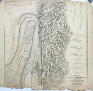
Sold2017Map of the Siege of Vicksburg, MississippiMap: Map of the Siege of Vicksburg, Mississippi Description: This large battle map identifies Union and Confederate entrenchments. It is very detailed, showing the roads, streets, houses, railroads, vSee Sold Price
Sold20181852 Mitchell Antique Map of TexasTitle/Content of Map: 1852 Mitchell Map of Texas -- No. 13 Map of the State of Texas Date Printed: 1852 Philadelphia Cartographer: S Mitchell / Cowperthwait & Co. Size: 8 x 10.4 in. A nice pre-Civil WSee Sold Price
Sold2018Map of Texas Oil Drilling Sites"Gallup's Map of Texas, Published by F.E. Gallup Map Co." Sight size: 20-1/2"h x 29"w Provenance: Bought from rare book sealer in Santa Fe, New Mexico.See Sold Price
Sold20211852 Cowperthwait, Desilver, Butler map of TexasThe horizontal layout not commonly seen. “No. 13 Map of the State of Texas Engraved to Illustrate Mitchell’s School and Family Geography.” Nicely detailed with original hand-coloringSee Sold Price
Sold2024Excellent example 1852 Map of the State of TexasVery clean, comprehensive map of Texas, showing the new boundaries after the Compromise of 1850, with inset maps of the panhandle and Galveston. Locates Apaches in the western part of the state, ComanSee Sold Price
Sold2017Mitchell: Antique Map of Texas, 1852Map: 1852 Mitchell Map of Texas -- Map of the State of Texas Date Printed: 1852, Philadelphia Cartographer: S Mitchell Size: 8 x 10.5 in. Condition: Very good. Toning and finger soiling, mostly in theSee Sold Price
Sold2017Cowperthwait/Desilver: Antique Map of Texas, 18521852 Cowperthwait, Desilver & Butler map of Texas. The horizontal layout not commonly seen. Nicely detailed with original hand-coloring. Shows Indian tribes, forts, rivers, topography, etc. DelineatedSee Sold Price
Sold2021Hand Drawn Map of "Edgefield Area Potteries"Framed hand drawn and colored map "Edgefield Area Potteries: 1810-1880", signed and dated "C. Alderman, Penman / 2007"; map identifies the 19th century pottery sites in the Edgefield District of SouthSee Sold Price
Sold20221865 Life of Davy Crockett TEXAS Americana Creek WAR Battle ALAMO Illustrated1865 Life of Davy Crockett TEXAS Americana Creek WAR Battle ALAMO Illustrated “I know, that obscure as I am, my name is making a considerable deal of fuss in the world.” ― Davy CrocSee Sold Price
Sold20201852 HAND TINTED OLD ANTIQUE MAP of TEXAS, MITCHELL s1852 HAND TINTED OLD ANTIQUE MAP of TEXAS, MITCHELL s SCHOOL & FAMILY GEOGRAPHY 1852 Antique Map by S. Augustus Mitchell of Pennsylvania. ??No. 13 - MAP OF THE STATE OF TEXAS. Engraved to Illustrate MSee Sold Price
Sold20171852 S.A. MITCHELL MAP OF THE STATE OF TEXASFramed "Map of the State of Texas, Engraved to Illustrate Mitchell's School and Family Geography", 1852 by S.A. Mitchell (Samuel Augustus Mitchell, Philadelphia, 1790-1868), engraved by J.H. Young, haSee Sold Price
Sold2020German map of California & Texas 1852Heading: (Texas) Author: Meyer, Joseph Title: Vereinigte Staaten von Nord-America: Californien, Texas und die Territorien New Mexico u. Utah Nach den neuesten Hülfsmitte In gezeich. von J. Grässl. 1See Sold Price
Sold2021WILL HADDON (American. 20th Century)Bonhomme vs. Serapis. Signed l/l, reverse with a map of The British Isles, showing the battle site and date, Sept. 23, 1779, with title plaque. Oil on Masonite. 18.5 by 24 in., in a painted frame 26 bSee Sold Price
Sold2022Sol Casa, Alamo Battle SceneSol Casa, Alamo Battle Scene, oil on board, size: 20 x 28" Provenance: A San Antonio, Texas collection We happily provide seamless shipping services on everything we sell. Please email us at shippiSee Sold Price
Sold20221865 TEXAS 1ed Life of Davy Crockett Creek WAR ALAMO Battle Illustrated1865 TEXAS 1ed Life of Davy Crockett Creek WAR ALAMO Battle Illustrated “I know, that obscure as I am, my name is making a considerable deal of fuss in the world.” ― Davy Crockett ASee Sold Price
Sold2020Unusual configuration in the Southwest U.S., 1852 mapHeading: Author: Philip, George, & Son Title: Central America Including Mexico, Texas and California Place Published: Liverpool Publisher: Date Published: c.1852 Description: EnSee Sold Price
May 29Cedarburg Auction & Appraisals LLCSet of Four Maps Showing All of Spain and Portugal$175(2 bids)
6 days LeftPotter & Potter Auctions[WELLESLEY, Arthur, First Duke of Wellington (1769-1852), s...$250
Jun 02Schilb Antiquarian Rare Books1871 Alfred the Great King of England MAP Battle of Ashdown Vikings Thom Hughes$125(3 bids)
Jun 23Schilb Antiquarian Rare Books1848 Emory Military Reconnaissance 1ed California MAP Indians Texas New Mexico$1
May 30Antiques Online AuctionsVintage Texas 1845 Map Printed in 1986, Compiled by John Davis$1(1 bid)
Jun 02Schilb Antiquarian Rare Books1848 RARE Halls of Montezumas MEXICO Texas America War Zachary Taylor Battles$3(3 bids)
1 day LeftBlackstone Valley Auctions & Estates LLCRevolutionary Era War Map of the Attack on Ft. Moultrie.$275(3 bids)
4 days LeftHess Fine AuctionsSchool of Geoff Winningham Texas Southwest Cowgirl Cheerleaders Black White Photograph$10
Jun 23Schilb Antiquarian Rare Books1852 Uncle Toms Cabin RARE & EARLY UK ed Beecher Stowe Slavery Abolition$2(2 bids)
May 31Freeman's | Hindman[CIVIL WAR]. Archive of items related to Elisha Hunt RHODES (1842-1917), 2nd Rhode Island Volunteer$750
Jun 23Schilb Antiquarian Rare Books1831 Northern Traveller Voyages to NIAGARA Falls Quebec Canada Illustrated MAPS$1
Jun 23Schilb Antiquarian Rare Books1816 Napoleonic War ENGLISH 1ed Campaigns Russia Invasion Labaume MAPS Napoleon$1
Featured4 days LeftJasper521750. Naval battle between Algerian privateers and two Maltese frigates in the Mediterranean Sea$300
Jun 02Schilb Antiquarian Rare Books1899 STONEWALL JACKSON Civil War Confederate Military + Wolseley PROVENANCE$2(2 bids)


![[CIVIL WAR]. Archive of items related to Elisha Hunt RHODES (1842-1917), 2nd Rhode Island Volunteer (1 of 6)](https://p1.liveauctioneers.com/197/329785/177758366_1_x.jpg?height=282&quality=70&version=1715625218)


