Sold2021[MAPS] THREE EARLY MAPS OF NORTH AMERICA[MAPS] Three early maps of North America Three maps of North America sold together, including: Francois, Delmarche. AMERIQUE SEPTENTRIONALE. 1833. Engraved map. 27.5 X 33 cm (plate mark). ** Bellin, JSee Sold Price
Sold2017Marble and Malachite Obelisks & a map (three)A pair of obelisks, 20” & 16”; Together with Gerard Valk & Petrus Schenk Publishing SCENO SYSTEMATIS PTOLE, a modern lithograph with hand-coloring, image 16 ½ x 19 ½”, Graphia Mundani Maici, fSee Sold Price
Sold2019Colton's St. Louis/Chicago Map [Midwest City Map]Colton's Pittsburgh and Cincinnati Map; top is Pittsburgh and bottom is Cincinnati. J. H. Colton Cartographer. Published by J. H. Colton, New York. Stamped 'Entered according to Act of Congress in theSee Sold Price
Sold2019Colton's St. Louis/Chicago Map [Midwest City Map]Colton's St. Louis and Chicago Map; left is St. Louis and right is Chicago. J. H. Colton Cartographer. Published by J. H. Colton, New York. Stamped 'Entered according to Act of Congress in the Year 18See Sold Price
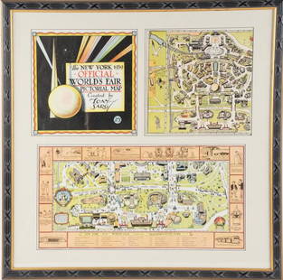
Sold2022Framed Tony Sarg 1939 World's Fair Pictorial MapTony Sarg (American, 1880-1942), "The New York 1939 Official World's Fair Pictorial Map Created by Tony Sarg 25¢" cover and Transportation Zone maps, three pieces matted and under glass in paintedSee Sold Price
Sold2021ASSORTED AMERICAN / CANADIAN STOCK CERTIFICATES, LOT OFASSORTED AMERICAN / CANADIAN STOCK CERTIFICATES, LOT OF NINE, including 1927 Durant Motor Company of New Jersey; 1909 Frances Gold Mines, Limited, Ontario; three 1907 The Silbert Consolidated Mining CSee Sold Price
Sold2017Johnson: Set of 2 Antique Maps of Ontario/New FoundLandTitle/Content of Map: Canada set of 2 Maps Ontario/New Found-Land Nova Scotia Date Printed: 1868 Cartographer: A.J. Johnson Material/Medium: Paper Size: 24 1/2" x 18" Hand colored steel engraved Map.See Sold Price
Sold2017Mitchell: Antique Map of Ontario in Counties, 1869Map: Ontario in counties Date Printed: 1869 Cartographer: Augustus S. Mitchell Material/Medium: Paper Size: 15 1/4" x 12 1/4" Hand colored engraved map. Printed in Philadelphia. From his 'Mitchell's NSee Sold Price
Sold2020Three maps, late 18th-early 19th centuryThree mapslate 18th-early 19th centuryComprising a French hand-colored copperplate map of Virginia, 1760-1762; a map of the United States, 1719, by H.A. Chatelain, Amsterdam; and a map of Delaware, 18See Sold Price
Sold2022Three Maps of North America, One World MapFour maps, including: Robert Wilkinson, The United States of America Confirmed By Treaty 1783, London, circa 1800-1812, engraving on wove paper; L'Amerique Septentrionale, "Terres vues par Tchirikov 1See Sold Price
Sold2023THREE MAPS OF MAINE 19th CenturyTHREE MAPS OF MAINE19th Century1) J.J. Stoner map of Thomaston. Framed 20.25” x 28”.2) E.M. Woodford 1855 rolled map of Thomaston Village. Approx. 47” x 39”.3) Lee & Marsh 1857See Sold Price
Sold2019Three Maps by Franz Ludwig Güssefeld (1744-1808),Three Maps by Franz Ludwig Güssefeld (1744-1808), "Charte Uber DIE XIII Vereinigten Staaten Nord America," 1784,hand colored, H. - 18 1/2 in., W. - 23 1/2 in. (3 Pcs.)See Sold Price
Sold2019Three Maps by Matthiae Hasii (Homann Heirs),"AmericaeThree Maps by Matthiae Hasii (Homann Heirs),"Americae Mappa Generalis," 1746, hand colored, H.- 19 1/4 in., W.- 22 1/4 in., (3 Pcs.)See Sold Price
Sold2022THREE MAPS OF CAPE COD 20th Century Largest framed 19” x 23”.THREE MAPS OF CAPE COD20th CenturyTwo reproductions. The other by Walter Gaffney and dated 1932.Largest framed 19” x 23”.See Sold Price
Sold2019Three Maps by Guillaume De LThree Maps by Guillaume De L'Isle (1675-1726), "America Septentrionalis," H. -21 1/2 in., W. - 26 in.See Sold Price
Sold2017Ortelius: Three maps of the Near EastThree maps printed from a single engraved plate, from Theatrum Orbis Terrarum, Antwerp, 1598: "'Natoliae, Quae Olim Asia Minor, Nova Descriptio;" "Aegypti Recentior Descriptio …;" "and "CarthaginisSee Sold Price
Sold2022Delamarche - Three Maps of the AmericasCharles Francois Delamarche (1740-1817), including: Amerique Septentrionale; Amerique Meridionale; Carte Des Etats-Unis; published in Paris, each in two sheets, engravings on laid paper with hand coloSee Sold Price
Sold2022Three celestial maps by F. J. Huntington. Each map represents three months of the celestial cycle.Three celestial maps by F. J. Huntington. Each map represents three months of the celestial cycle. Missing the map for January, February, and March. Dimensions are: 14 3/8 inches tall X 13 3/4 inchesSee Sold Price
Sold2022Set of Three MapsSet of Three Maps, to include geographical, statistical, and historical maps of Missouri, Illinois, and Mississippi, plate numbers 34, 33, and 29, hand colored copper engravings, having information teSee Sold Price
Sold2022Three Maps of Africatwo Colton maps, Tanner Map largest- Henry S. Tanner Africa Philadelphia, 1823 22"x22", framed 36"x34"See Sold Price
Sold2021Three MapsA city map, a topographical map and a Human Race distribution map. [Largest: 24" H x 36" W].See Sold Price
Sold2017Three maps of Africa and Middle Eastcomprising: 1) Nicolas Sanson, "Haute Ethiopie …" Paris, 1655, engraving, about 16 X 20 in., p.m.; 2) after Sanson, "Description de l'Empire du Sophi des Perses," Paris, c,1730, engraving with old oSee Sold Price
Sold2016Three maps of AsiaHeading: (Asia) Author: Title: Three maps of Asia Place Published: Various places Publisher: Date Published: Various dates Description: Includes:See Sold Price
21 hrs LeftForum AuctionsRussia.- Peter the Great.- Uystryalov (Nikolai) Karty, Plany I Snimki K Pervym Trem Tomam£750
Jun 23Schilb Antiquarian Rare Books1855 San Francisco 1st ed California Gold Rush Illustrated MAPS Soule Indians$1(1 bid)
1818 AuctioneersLiterature. Peake, Mervyn - Gormenghast Trilogy. Three volumes - Titus Groan (1946, 1st);£50(1 bid)
1818 AuctioneersBeatrix Potter. Three issues from the 20 Watercolour Postcards series. The World of Beatrix£8
1818 AuctioneersLiterature. Jerome, Jerome K. - Three Men in a Boat. 1889, later state with '11 Quay Street' on£14
6 days LeftJasper521732 Homann Map of Nurnberg -- Grundris der des Heil Rom. Reichs Freyen Stadt Nurnberg$190
1818 AuctioneersIllustrated Books. Three titles: Lemaitre, Jules - A B C Petits Contes. Tours: Maison Alfred Mame Et£10
1818 AuctioneersWainwright. Two titles: Three Westmorland Rivers (1979) & Westmorland Heritage: Popular Edition (£8
1818 AuctioneersTravel. Far East. Three titles: Peck, Graham - Through China's Wall. London: 1941. 2nd impression;£10
1 day LeftPotter & Potter AuctionsFOOTE, Shelby (1916-2005). The Civil War. A Narrative. New ...$200(1 bid)


![[MAPS] THREE EARLY MAPS OF NORTH AMERICA: [MAPS] Three early maps of North America Three maps of North America sold together, including: Francois, Delmarche. AMERIQUE SEPTENTRIONALE. 1833. Engraved map. 27.5 X 33 cm (plate mark). ** Bellin, J](https://p1.liveauctioneers.com/1124/208511/106199207_1_x.jpg?height=310&quality=70&version=1624388585)


![Colton's St. Louis/Chicago Map [Midwest City Map]: Colton's Pittsburgh and Cincinnati Map; top is Pittsburgh and bottom is Cincinnati. J. H. Colton Cartographer. Published by J. H. Colton, New York. Stamped 'Entered according to Act of Congress in the](https://p1.liveauctioneers.com/5755/154409/77936936_1_x.jpg?height=310&quality=70&version=1573094011)
![Colton's St. Louis/Chicago Map [Midwest City Map]: Colton's St. Louis and Chicago Map; left is St. Louis and right is Chicago. J. H. Colton Cartographer. Published by J. H. Colton, New York. Stamped 'Entered according to Act of Congress in the Year 18](https://p1.liveauctioneers.com/5755/154409/77936935_1_x.jpg?height=310&quality=70&version=1573094011)


![Three Maps: A city map, a topographical map and a Human Race distribution map. [Largest: 24" H x 36" W].](https://p1.liveauctioneers.com/1221/219345/112910244_1_x.jpg?height=310&quality=70&version=1632498055)


![[BRITISH MILITARY GAZETTEER]. The Military Panorama, or, Of... (1 of 2)](https://p1.liveauctioneers.com/928/328184/176813576_1_x.jpg?height=282&quality=70&version=1714496988)


