Sold2022Road Atlases, Maps, Books With Mineral AreasIncluded are maps and books of geology and mineral resources in North Carolina, AAA road maps of Colorado and Wyoming, two road atlases for Baltimore County and New Hampshire. Some areas are denoted aSee Sold Price
Sold2022Postcards, Photo Books,Maps and Guide Books.Postcards, Photo Books,Maps and Guide Books. Pompeii, France, North Wales, London, Paris, Arundel and Windsor Castle, Imperial War Museum, Pratts England and Wales Road Atlas etc. (39 items)See Sold Price
Sold20201798 1ed Cary ROADS New Itinerary England Wales1798 1ed Cary ROADS New Itinerary England Wales Topography Atlas Travel Guide John Cary was a famous English cartographer from the 18th-century. Cary gained his reputation as a map maker from his workSee Sold Price
Sold20212 Large Scrapbooks of Shell Oil 30's US Road Map BooksPair of Folio Style Shell Oil 1930s US Road Map Books. These map booklets, with tabs for various US States like North Carolina, South Carolina, Virginia, West Virginia, and Texas, were published by ShSee Sold Price
Sold2023Vintage road atlas, map manuals, and moreVintage road atlas, map manuals, and moreSee Sold Price
Sold20221833 Jos. Perkins A New General Atlas Map Book1833, written and engraved by Jos. Perkins, publisher - Anthony FinleySee Sold Price
Sold20181911 Philadelphia 24 34 44 Wards Atlas Map BookFirst few pages have wear, tear , and a couple are loose.See Sold Price
Sold20181928 Philadelphia 26th 36th 48th Wards Atlas Map BookApprox. 22" x 18 1/2" and 1 1/4" thickSee Sold Price
Sold2017VARIOUS ATLAS AND MAP BOOKSVARIOUS ATLAS AND MAP BOOKS- RAND McNALLY FAMILY WORLD ATLAS- SIXTH PRINTING 1987- HARD COVER- THE MAP BOOK EDITED BY PETER BARBER- FIRST PUBLISHED IN THE U.S. IN 2005- HARD COVER- THE MAP CATALOG- 3RSee Sold Price
Sold2020Ogilby, John 1939 Facsimile Atlas. Road Maps, UK"Britannia, Volume the First..." Facsimile Edition of the 1675 Edition by John Ogilyby & Alexander Duckham, 1939. Oblong 4to (315 x 250mm) 100 Maps printed both sides on 50 sheets. Cloth bound, a littSee Sold Price
Sold2021Atq Map & Atlas Books, 1899 Spoffords & More - 1899Atq Map & Atlas Books, 1899 Spoffords & More - 1899 Maps Spofford's Cabinet Encyclopedia, 1906 Hammonds Pictorial Atlas of World w/ 1956 Hammond Double Day AtlasSee Sold Price
Sold2024Shell Oil Company Road Map AtlasLarge binder with Shell logo, includes states and city maps, overall size 18.5"x13.5"See Sold Price
Sold2022[CATALOGUES] A large group of early auction and dealer catalogues relating to rare books, maps &[CATALOGUES] A large group of early auction and dealer catalogues relating to rare books, maps & atlases, and related collections, 1950s-70s. A fine large collection of auction catalogues from Parke BSee Sold Price
Sold2021Ephemera AssortmentEphemera Assortment Including books, magazines, sheet music, newspapers, coloring books, road maps and advertising Property from: Mooncat Antiques, Lake in the Hills, Illinois Condition: Good to Fair,See Sold Price
Sold2022Vintage Travel Destination Maps & EphemeraThere is a 1949 Rand McNally road atlas, 40+ vintage maps including locations such as New York, Pittsburgh, Boston, Ohio, Pennsylvania, New Jersey, advertising ephemera for various companies includingSee Sold Price
Sold2021Large Group of Vintage Maps,Road Atlas - Atlas of theLarge Group of Vintage Maps,Road Atlas - Atlas of the World War, Atlas Portfolio w/ Asst Loose Maps, Maps from Around The WorldSee Sold Price
Sold2019Vintage Road Maps (14)Including 1980-1981 New Jersey map & guide; (3) Somerset & Hunterdon Counties New Jersey map; Burlington Bridges Area Road map; Northern Hunterdon County, NJ map; Sunoco New York map; Texaco Florida,See Sold Price
Sold2023Group of 10 Assorted EphemeraIncludes Indiana Sinclair Road Map, Chicago souvenir book, Booklets, and more, Largest measures 7 1/2 x 10 1/2 inches.See Sold Price
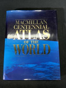
Sold2022Macmillan Centennial Atlas of the World BookMacmillan Centennial Atlas of the World. Published by Macmillan, 1997. Wear to cover and jacket consistent with exposure. Measures approx. 12 x 15.5 inches. Atlas, map, topography, photo book, referenSee Sold Price
Sold20182 Boxes of Books on Maps & Atlases2 Boxes of Books on Maps & Atlases-- Dimensions: ---See Sold Price
Sold20211830 "A New Atlas World" Educational School Map Book1830 "A New Atlas World"Antique Educational School Maps. This is a wonderful antique atlas for early education, geography classes. It has a layout of the world and the breakdown of each continent. BecSee Sold Price
Sold2020Grp: 10 Maps of British Cities w/ 1 Map VeniceGroup of maps of British cities. Includes one map of Birmingham; two road maps for the London area: "A Map of the New Roads & c. from Westminster Bridge" and "A Plan of the intended New Road from PadiSee Sold Price
Jun 13Swann Auction Galleries(CANADA.) Thomas Jefferys. A Large and Particular Plan of Shegnekto Bay, and the Circumjacent$1,100
Jun 13Swann Auction Galleries(PHILADELPHIA -- ROXBOROUGH/MANAYUNK.) John Levering. Plan of the Township of Roxborough$500
Jun 13Swann Auction Galleries(HONDURAS -- ROATAN ISLAND.) Lieutenant Henry Barnsley; and William H. Toms, engraver. A Draught of$750
Jun 13Swann Auction Galleries(CANADA.) Jonathan Carver. A New Map of the Province of Quebec, According to the Royal Proclamation$450
Jun 13Swann Auction Galleries(NEW YORK CITY.) Bernard Ratzer. [The Ratzen Plan] To His Excellency Sr. Henry Moore. Bart.,$19,000
Jun 13Swann Auction Galleries(NEW YORK -- CATSKILL MOUNTAINS.) Edwin E. Howell. Relief map of Catskill Mountains.$450
Jun 13Swann Auction Galleries(COLORADO.) Louis Nell; and Chain, Hardy & Co. Nell's Topographical & Township Map of the State of$600
Jun 13Swann Auction Galleries(TITLE PAGES.) Group of 10 seventeenth-and-eighteenth-century engraved allegorical atlas title$600
3 days LeftHolabird Western Americana CollectionsNevada Mining District Collection, 1923-79 (12) [181938]$75
Jun 13Swann Auction Galleries(TRI-STATE AREA.) A.R. Ohman Map Co. Map Showing 100 Miles Around New York City.$450
Jun 13Swann Auction Galleries(NEW YORK CITY.) G.W. Colton; and J.M. Atwood. Map of the Country Thirty Three Miles Around the City$600
Jun 13Swann Auction Galleries(AMERICAN REVOLUTION.) Robert Sayer and John Bennett. The Theatre of War in North America, with the$2,200
Jun 13Swann Auction Galleries(UNITED STATES.) James Hamilton Young; and Samuel Augustus Mitchell. Traveller's Guide Through the$450
Jun 13Swann Auction Galleries(BOTANICAL.) Basilus Besler. Two hand-colored engraved plates of tulips from Hortus Eystettensis.$375(1 bid)
Jun 13Swann Auction Galleries(NEW YORK CITY.) H. Walter; after John Bachmann. Vue General de New-York.$2,200
Jun 13Swann Auction Galleries(CONNECTICUT.) William Lester, Jr. Map of New London and Windham Counties in Conn.$600
Jun 13Swann Auction Galleries(PHOTOGRAPHY -- STEREOVIEWS.) Carleton Watkins, J.J. Reilly, and others. Group of approximately 80$750


![[CATALOGUES] A large group of early auction and dealer catalogues relating to rare books, maps &: [CATALOGUES] A large group of early auction and dealer catalogues relating to rare books, maps & atlases, and related collections, 1950s-70s. A fine large collection of auction catalogues from Parke B](https://p1.liveauctioneers.com/292/250642/130213445_1_x.jpg?height=310&quality=70&version=1654271664)


![(KOREA.) [Miniature manuscript road atlas]. (1 of 3)](https://p1.liveauctioneers.com/199/332329/179231727_1_x.jpg?height=282&quality=70&version=1717450360)


![(NEW YORK CITY.) Bernard Ratzer. [The Ratzen Plan] To His Excellency Sr. Henry Moore. Bart., (1 of 1)](https://p1.liveauctioneers.com/199/332329/179231669_1_x.jpg?height=282&quality=70&version=1717450360)


![Nevada Mining District Collection, 1923-79 (12) [181938] (1 of 9)](https://p1.liveauctioneers.com/2699/331499/178846289_1_x.jpg?height=282&quality=70&version=1717095214)


![(KOREAN ATLAS.) Ch'onha Chido [Atlas of all under Heaven]. (1 of 4)](https://p1.liveauctioneers.com/199/332329/179231729_1_x.jpg?height=282&quality=70&version=1717450360)
