Sold20171848 Houze ATLAS Geography 101 MAPS Europe Africa1848 Houze ATLAS Geography 101 MAPS Europe Africa America Hand-Colored England A rare 19th-century atlas filled with over 100 full-page maps hand-traced in color. These maps by Antoine Philippe HouzeSee Sold Price
Sold2022Antique French Map of AfricaAntique French Map of Africa. "Carte de L'Afrique..."by J. Andriveau-Goujon, Paris, dated 1841. Framed. Ex. Collection William and Diane Bousquette, Purchase, New York. Size: 15'' x 19.5'', 38 x 50 cmSee Sold Price
Sold2023French map of Africa published by Bonne 1780Rigobert Bonne (6 October 1727 – 2 September 1794) work represents an important step in the evolution of the cartographic ideology away from the decorative work of the 17th and early 18th centuSee Sold Price
Sold2017Antoine Bouvard A pair: "Paris Street Scene"ANTOINE BOUVARD (French 1840 - 1920) A Pair: Two Paris Street Scene Each oil on canvas Each: 13 x 18 inches / 33.02 x 45.72 cm Each signed lower right: Bouvard Condition: Each in good conditionSee Sold Price
Sold2017ANTOINE BOUVARD (French 1840-1920) A PAINTING, "QuietANTOINE BOUVARD (French 1840-1920) A PAINTING, "Quiet on the Grand Canal, Venice," oil on canvas, signed L/R. 20" x 26"See Sold Price
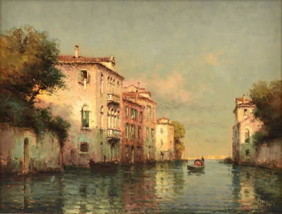
Sold2024Joseph Antoine Bouvard (French, 1840-1920)Joseph Antoine Bouvard (French, 1840-1920), "Venice - Grand Canal", oil on canvas, signed lower left, 15 1/4 in. x 21 5/8 in., framed, overall 23 1/8 in. x 28 3/4 in. x 2 5/8 in.See Sold Price
Sold2018(4) ANTIQUE FRENCH MAPS - FROM CHRISTIE'S AUCTIONFour antique French maps of Africa & Middle East. They were purchased from Christie's auction in 1994. Measures 8.75" x 7.75" to 16.25" x 13.5" w/ frames.See Sold Price
Sold2022Cortambert french Africa map 1864 engraving hand coloredEugene Cortambert (french, 1805-1881): french Africa map, copper hand colored engraving, from Geographie Universelle de Malte-Brun published in 1864 in Paris by Boulanger & Legrand.24" X 19”.DimSee Sold Price
Sold202117th C. French Engraving Map of N. Africa MoroccoFrench hand-colored engraving of North Africa, including Morrocco, parts of Algeria, Strait of Gibraltar. Dated 1655. Measures 16"H x 21"W visual image , 23.75"H x 27.75"W framed. Condition report: GoSee Sold Price
Sold2023Two Maps, Africa by Eustache Herisson, 1809, World Hemispheres 1832 Reprint after A.H Brue, GermanDescription: An antique Africa map, in French and dated 1809 by Eustache Herisson, and a reprit of an early 19th century map of World Hemispheres by Adrien-Hubert Brue. Type: MapMaterials: PaperMarkinSee Sold Price
Sold20171807 William Guthrie French ATLAS Illustrated MAPS1807 William Guthrie French ATLAS Illustrated MAPS Asia Africa France America Originally translated into French in 1801, William Guthrie’s “Geographical, Historical and Commercial Grammar’, hasSee Sold Price
Sold2020LARGE FRENCH SCHOOL Aid politica MAP OF AFRICA MIDPublished by the Librairie Amand Collin in Paris Circa 1950 edited by Vidal and Lablache this map shows the political boundaries of the African colonies of the 1950 with a color coding including theirSee Sold Price
Sold2020Craste, Leon. Afrique Occidentale Francaise. Paris: A.Craste, Leon. Afrique Occidentale Francaise. Paris: A. Karcher, 1930s. A lovely pictorial map of French West Africa with vignettes and insets throughout. 32 x 47”. Folds present with inpainting.See Sold Price
Sold20191840 SDUK Map of West Africa -- West Africa ITitle/Content of Map: 1840 SDUK Map of West Africa -- West Africa I Date: 1840 London Cartographer: SDUK Size: 12.2 x 15.1 in. This is a fantastic Map of todays Mauritania (in part), Senegal, Gambia,See Sold Price
Sold2022ODILON REDON, LITHOGRAPH, TENTATION DE ST. ANTOINEOdilon Redon (French 1840-1916), "Des peuples divers habitent les pays de l'océan" (Different Peoples Dwell in the Countries of the Ocean), lithograph from La Tentation De St. Antoine, apparently uSee Sold Price
Sold2022Wyld, James 1840 LG Hand Col Map. West Africa"Map of Part of the Western Coast of Africa Extending from the Isles de Loss to Sherboro Island" Showing Sierra Leone and area. Hand Colored Steel Engraved Map By Surgeon O'Beirne and Major Laing. PubSee Sold Price
Sold20221738 Geography ATLAS 16 Maps Africa Italy Asia Buffier Poland Ottoman Turkey1738 Geography ATLAS 16 Maps Africa Italy Asia Buffier Poland Ottoman Turkey Known primarily for his contributions to philosophy, Claude Buffier, a 17th-century French Jesuit historian, published a woSee Sold Price
Sold2024Colonial Africa. Ethnicity. British French Portuguese Belgian. TIMES 1922 mapTITLE/CONTENT OF MAP: 'Africa - Political' DATE PRINTED: 1922 IMAGE SIZE: Approx 44.0 x 57.5cm, 17.25 x 22.5 inches (Large); Please note that this is a folding map. TYPE: Antique atlas map CONDITION:See Sold Price
Sold2023Colonial Africa. Ethnicity. British French Portuguese Belgian. TIMES 1922 mapTITLE/CONTENT OF MAP: 'Africa - Political' DATE PRINTED: 1922 IMAGE SIZE: Approx 44.0 x 57.5cm, 17.25 x 22.5 inches (Large); Please note that this is a folding map. TYPE: Antique atlas map CONDITION:See Sold Price
Sold2023Colonial Africa. Ethnicity. British French Portuguese Belgian. TIMES 1922 mapTITLE/CONTENT OF MAP: 'Africa - Political' DATE PRINTED: 1922 IMAGE SIZE: Approx 44.0 x 57.5cm, 17.25 x 22.5 inches (Large); Please note that this is a folding map. TYPE: Antique atlas map CONDITION:See Sold Price
Sold2022Nicolas de La Mare (French, 1639–1723), Antoine Coquart (French, 1668–1707), and Nicolas de FerNicolas de La Mare (French, 1639–1723), Antoine Coquart (French, 1668–1707), and Nicolas de Fer (French, 1646-1720), "Cinquieme Plan de la Ville de Paris," c. 1705, hand-colored map, preSee Sold Price
Sold2023ANTOINE PONTHUS-CINIER (French, 1812-1885)Figure in Italianate landscape (Champagne Romaine), ca. 1840 Oil on canvas Signed bottom right H. 22 3/4" W. 28 1/2" Provenance: Paul Bert (Paris)See Sold Price
Sold2021Pluche, Noel 1748 Map of Africa"Le Port d'Ophir…" Copper Engraved Map Published 1748, The Hague for "Le Spectacle de la nature" by Noel Antoine Pluche. Paper Size: 6 x 4 inch (16 x 10cm) A few tiny tone spots. Good ConditionSee Sold Price
Sold2019Pluche, Noel 1748 Map of Africa"Le Port d'Ophir…" Copper Engraved Map Published 1748, The Hague for "Le Spectacle de la nature" by Noel Antoine Pluche. Paper Size: 6 x 4 inch (16 x 10cm) A few tiny tone spots. Good ConditionSee Sold Price
May 16Potter & Potter AuctionsAUDIBERTI, J. Choain. Afrique Equatoriale Francaise. Paris:...$100(1 bid)
2 days LeftL'Autographe LtdHISTORY - LECLERC Philippe Antoine (1902 - 1947) - Signed printed photograph£300
4 days LeftJasper521733 BIBLE OLD TESTAMENT COMMENTARY by CALMET VELLUM FOLIO antique w/ LARGE MAP$160
3 days LeftPlakas AuctionsL’Univers Pittoresque Turquie, Histoire et Description de Tous Les Peuples, Joseph Marie Jouannin£600
Featured11 hrs LeftInternational Art Auction GalleryClaude Monet French 1840 - 1926 Oil on canvas Painting in the style of. Renoir Manet Pissarro Era.$1,300(5 bids)
Featured11 hrs LeftInternational Art Auction GalleryClaude Monet French 1840 - 1926 Oil on canvas Painting in the style of.Renoir Manet Pissarro Era.$1,300(5 bids)
11 hrs LeftInternational Art Auction GalleryClaude Monet French 1840 - 1926 Oil on canvas Painting in the style of. Renoir Manet Pissarro Era.$1,600(7 bids)
May 04International Art Auction GalleryClaude Monet French 1840 - 1926 Oil on Canvas Painting In The Style of. Renoir/Manet/Pissarro Era.$400(2 bids)
May 04International Art Auction GalleryClaude Monet French 1840 - 1926 Oil on Canvas Painting In The Style of. Renoir/Manet/Pissarro Era.$101(2 bids)
8 hrs LeftJeffrey S. Evans & AssociatesLIONELLO BALESTRIERI (ITALIAN, 1872-1958) INTERIOR GENRE SCENE$200
May 16Freeman's | HindmanAntoine Blanchard (French, 1910-1988) Théâtre du Châtelet, Quai de Gesvres, Paris$1,000
May 16Freeman's | HindmanAntoine Blanchard (French, 1910-1988) Rue de la Paix, Place Vendôme$1,500