Sold2024Willem Blaeu, Map of The AmericasAmsterdam, 1617. Together with "Early Maps" by Tony Campbell, Abbeville Press and "The United States in Old Maps and Prints, Eduard Van Ermen. 3 pieces Sight size: 16-1/2"h x 22"w Overall: 23-1/2"h xSee Sold Price
Sold2023Group of 16 South Pacific and Rock Island Railroad Items - Golden State Advertisements, Timetables,Group of Golden State advertisements, timetables, map, folios of photo prints, and posters. 2 Timetables for the Sunset and Golden State Routes dated 1940 and 1957. The older timetable has moderate diSee Sold Price
Sold20171873 Southern Central Annual Passes: IC, MC&NW3 annual passes from central southern states: (1) Illinois Central (2) Memphis Carthage & Northwestern - Frisco predecessor (3) Ohio & Mississippi with fine map on reverse.See Sold Price
Sold20241876 Mitchell Map of Illinois -- County and Township Map of the State of IllinoisTitle: 1876 Mitchell Map of Illinois -- County and Township Map of the State of Illinois Cartographer: S Mitchell Year / Place: 1876 Philadelphia Map Dimension (in.): 20.9 X 14.2 in. This is a very niSee Sold Price
Sold202219TH C. RAILROAD MAP PRINTS - LOT OF 219TH C. RAILROAD MAP PRINTS - LOT OF 2 Lot of 2 railroad map prints, circa 19th century, includes: 1857 Map of the Railroads of the state of New York, drawn by David Vaughan, Lith. C. Van BenthuSee Sold Price
Sold2024Signed & FramedPictorial Map Of The New England States Designed & Drawn By Ernest Dudley ChaseThis lot contains a Signed & Framed Print Pictorial Map Of The New England States Designed & Drawn By Ernest Dudley Chase . The frame is approx 26 1/2" x 20 3/4" while the map is approSee Sold Price
Sold201819C Oak Map Blueprint Ephemera Collector's CaseUnited States,Late 19th Century Squat five drawer cabinet, used for holding maps or blue prints. Oak 46" x 35" x 15 1/2", From an Exeter, Rhode Island estate.See Sold Price
Sold2021Pictorial Map United States IndiansIndians of the U.S.A. Louise E. Jefferson. Friendship Press, New York: 1944. Novelty map showing native American tribes. Vintage color print. 22 1/2" x 34 1/2", overall 26" x 40".See Sold Price
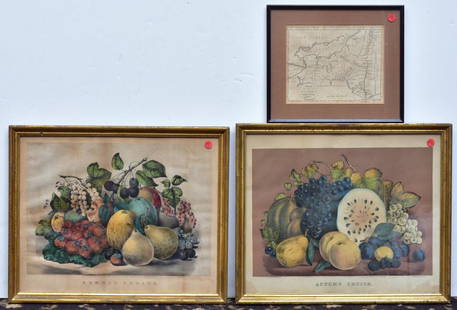
Sold2020Two Currier & Ives PrintsAutumn Fruits and Summer Fruits each 15 1/2" x 19" stone lithographs and a Map of the State of New York by J. Denison, published by Thomas & Andrews, Boston, 1796See Sold Price
Sold2021Map showing Indian Reservations, Norris Peters CoTitle: Map showing Indian Reservations within the limits of the United States.Photo-lithograph, 1904. Published by the Norris Peters Co., Washington, D.C. Image size 21 1/8 x 33 3/16" (53.6 x 84.2 cmSee Sold Price
Sold20202 Antique Map PrintsEach overall with frame 22" high x 28" wide. IMPORTANT: Before bidding, please read the terms and conditions below. When you registered for the auction you agreed to these terms and will be required tSee Sold Price
Sold20232 World Map Prints on Fabric23-1/2" high x 31-1/2" wide. LR IMPORTANT: Before bidding, please read the terms and conditions. When you registered for the auction you agreed to these terms and will be required to comply with them.See Sold Price
Sold2023Fritz Scholder Indian Portrait #2 1st State PrintFritz William Scholder V (American/La Jolla Band of Luiseno Indian, 1937-2005). Color lithograph titled "Indian Portrait No. 2," First state, depicting a portrait of a Native American man agSee Sold Price
Sold20162 United States Maps, including 1817.2 United States Maps, including 1817. 1st item: Northern Provinces of the United States map by John Thomson from "Thomson's New General Atlas", engraved by Nathaniel Rodgers Hewitt, 1817. Colored mapSee Sold Price
Sold2017Two(2) Albrecht Durer PrintsTwo(2) later state prints. Matching walnut frames; 4in. X 3in.(approx.)See Sold Price
Sold2022Illinois State Map AssortmentIllinois State Map Assortment (5) items including 'Illinois' by Anthony Finley, Philadelphia c.1830, depicting land assigned to the Sac and Fox, Winnebago and Ottawa Nations before forcibly removed; 'See Sold Price
Sold2024(2) Texas State Capitol Prints(2) Texas State Capitol prints, to include: -Benjamin Knox, "Texas Capitol", AP lithograph -Early engraving of the Texas capitol, offset lithograph sight: 14 x 23 in., frame: 24.5 x 33.5 in.See Sold Price
Sold2023(2) Texas Maps & Sesquicentennial PrintLot containing (3) framed pieces, to include two (2) Texas related maps, and a signed print celebrating the Texas Sesquicentennial sight: 30 x 25 in., frame: 39 x 33 in. We happily provide seamlessSee Sold Price
Sold2017Rand McNally The United States in Old Maps & PrintsTitle: The United States in Old Maps and Prints. New York. Rand McNally. 1990 Author(s): van Ermen, Eduard First edition. Condition: Fine copy in fine dust jacket (in mylar). Folio. Hard cover. FirstSee Sold Price
Sold20162 Maps incl: Scull and Heap. A MAP OF PHILADELPHIA[United States] 2 Maps. ++ N. Scull and G. Heap. A MAP OF PHILADELPHIA And Parts Adjacent. From the folding map’s 2nd appearance in Gentleman’s Magazine [Lon: Dec. 1777], without the table of distSee Sold Price
Sold20212 18th/19th C United States Maps1.) 1831 Map of the Eclipse of Feb 12th in its Passage Across the United States. Published by Gray and Bowen. 9" high x 8-3/4" wide. Cut from book. 2.) 1797 United States map. Published by J. Wilkes.See Sold Price
Sold2022Antique Map Print - United States - AmericaSet of 4 Map Prints. Antique lithographic map originates from "Letts's Popular Atlas", being a series of maps delineating the whole surface of the globe, with many special and original features; and aSee Sold Price
Sold20172 early maps, Chili & Auriacus Princip, by Ortelius.2 Antique Hand-Colored Map Prints, "Royaume de Chili", a miniature map of Chili, South America ; and "Auriacus Principatus" ( by Ortelius), showing the region around the Roman city of Orange in southeSee Sold Price
Sold20232 50 x 38 Color Print Maps, Europe & South AmericaLot of 2 color print maps. Both in packaging that reads Giant color print maps of, size 50 x 38. New. Informative, practical. One full color map of Europe and 1 full color map of South America. EuropeSee Sold Price
Featured4 days LeftJasper52The Great Jewish Bride, after Rembrandt. Heliogravure from Amand Durand, 19th-Century old print.$280
5 days LeftJasper52World War 2. Guadalcanal Campaign 7-8 Aug 1942 Tulagi Landing Schedule 1959 map$10
5 days LeftJasper52World War 2. Guadalcanal Campaign 7-8 Aug 1942 Landing. Henderson Field 1959 map$10
5 days LeftJasper52World War 2. Guadalcanal Campaign. Landing 7 Aug 1942 & Concurrent Ops 1959 map$10
5 days LeftJasper52Océanique. Partie… Iles Mariannes #2 North Mariana Islands VANDERMAELEN 1827 map$40
5 days LeftJasper52Océanique. Partie… Iles Mariannes #2 North Mariana Islands VANDERMAELEN 1827 map$40
4 days LeftJasper52Ville and castle of Nograd (Novigrad). Hungary. Antique engraving print from XVII century.$180
Featured5 days LeftJasper52Bismarck Archipelago New Guinea New Britain 1943/4. Ports. World War 2 1961 map$8
10 hrs LeftTrillium Antique Prints & Rare BooksCarey, pub. 1814 - Map of the State of Tennessee$50(1 bid)


![2 Maps incl: Scull and Heap. A MAP OF PHILADELPHIA: [United States] 2 Maps. ++ N. Scull and G. Heap. A MAP OF PHILADELPHIA And Parts Adjacent. From the folding map’s 2nd appearance in Gentleman’s Magazine [Lon: Dec. 1777], without the table of dist](https://p1.liveauctioneers.com/179/85723/44108001_1_x.jpg?height=310&quality=70&version=1457209333)


