Sold20221876 Mitchell Map of Minnesota -- County Map of MinnesotaTitle: 1876 Mitchell Map of Minnesota -- County Map of Minnesota Cartographer: S Mitchell Year / Place: 1876 Philadelphia Map Dimension (in.): 13.8 X 11.4 in. This is a very nice map of Minnesota, witSee Sold Price
Sold20211876 Mitchell Map of Minnesota -- County Map ofTitle: 1876 Mitchell Map of Minnesota -- County Map of Minnesota Cartographer: S Mitchell Year / Place: 1876 Philadelphia Map Dimension (in.): 13.8 X 11.6 in. This is a very nice map of Minnesota, witSee Sold Price
Sold20181870 Mitchell Map of Minnesota -- County Map ofTitle/Content of Map: 1870 Mitchell Map of Minnesota -- County Map of Minnesota Date: 1870, Philadelphia Cartographer: S Mitchell Size: 13.8 x 11.5 in. This is nice county map of Minnesota. Great dealSee Sold Price
Sold20171862 Mitchell county map of Minnesota in near fineGreat chance to own an actual 150-year-old piece of history for a reasonable price. Beautiful and clean county map of Minnesota from Mitchell’s 1866 New General Atlas. When matted and framed, antiquSee Sold Price
Sold2017Mitchell: Antique Map of Minnesota, 18621862 Mitchell county map of Minnesota in near fine condition. Great chance to own an actual 150-year-old piece of history for a reasonable price. Beautiful and clean county map of Minnesota from MitchSee Sold Price
Sold2022County Map of Minnesota from S. A. Mitchell, Jr. (1874)Fully hand colored map of Minnesota divided into counties. Towns, capitols, roads, rivers, lakes, railroads, and proposed railroads are labeled. A wagon road from Fort Ridgely westward toward the MissSee Sold Price
Sold2024County Map of MinnesotaPublication Date: ©1862 Title: County Map of Minnesota Cartographer: GAMBLE, W. H. Publisher: S. Augustus Mitchell, Jr. Height: 13.8 Width: 11.5 Railroads shown and labelled. Reverse blank. FloraSee Sold Price
Sold2018Mitchell: MinnesotaReserve Reduced! The beautifully detailed and colored county map of Minnesota from the 1870 edition of Mitchell's popular New General Atlas of the world. Framed by the decorative vine motif border typSee Sold Price
Sold2019Eight (8) Augustus Mitchell MapsCollection of eight maps including New Jersey/Maryland Delaware 1872, Two north and South Carolina 1872 maps (15" x 12"), Minnesota 1890 , Florida and the Carolinas 1860, County map of the state of ArSee Sold Price
Sold20181876 Mitchell Map of Texas -- County Map of the StateReserve Reduced! Title/Content of Map: 1876 Mitchell Map of Texas -- County Map of the State of Texas Showing also portions of the Adjoining States and Territories Date: 1876 Philadelphia CartographerSee Sold Price
Sold20221876 Mitchell Map of California -- County Map of the State of CaliforniaTitle: 1876 Mitchell Map of California -- County Map of the State of California Cartographer: S. Mitchell Year/Place: 1876 Philadelphia Dimensions: 21.2 x 14.6 in. Description: An excellent large mapSee Sold Price
Sold20221876 Mitchell Map of Florida -- County Map of FloridaTitle: 1876 Mitchell Map of Florida -- County Map of Florida Cartographer: S Mitchell Year / Place: 1876 Philadelphia Map Dimension (in.): 10.6 x 13.5 in. Handsome county map of Florida. Virtually allSee Sold Price
Sold20191876 Mitchell Map of Maine -- County Map of the StateTitle/Content of Map: 1876 Mitchell Map of Maine -- County Map of the State of Maine Date: 1876 Philadelphia Cartographer: S MitchellSize: 13.4 X 10.6 in. This is a very nice map of Maine with inset oSee Sold Price
Sold20181876 Mitchell Map of New York -- County Map of theReserve Reduced! Title/Content of Map: 1876 Mitchell Map of New York -- County Map of the State of New York Date: 1876 Philadelphia Cartographer: S Mitchell Size: 13.5 x 21.3 in. A very nice, large maSee Sold Price
Sold20191876 Mitchell Map of Georgia and Alabama -- County MapTitle: 1876 Mitchell Map of Georgia and Alabama -- County Map of the State of Georgia and Alabama Cartographer: S Mitchell Date: 1876 Philadelphia Size: 13.5 x 21.3 in. Additional Information: This isSee Sold Price
Sold20241876 Mitchell Map of Ohio and Indiana -- County Map of Indiana and OhioTitle: 1876 Mitchell Map of Ohio and Indiana -- County Map of Indiana and Ohio Cartographer: S Mitchell Year / Place: 1876 Philadelphia Map Dimension (in.): 11.5 X 13.8 in. This is a very nice map ofSee Sold Price
Sold20241876 Mitchell Map of Illinois -- County and Township Map of the State of IllinoisTitle: 1876 Mitchell Map of Illinois -- County and Township Map of the State of Illinois Cartographer: S Mitchell Year / Place: 1876 Philadelphia Map Dimension (in.): 20.9 X 14.2 in. This is a very niSee Sold Price
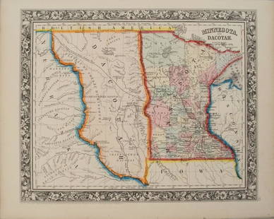
Sold20201860 Mitchell Map of Minnesota and the DakotasTitle/Content of Map: 1860 Mitchell Map of Minnesota and the Dakotas --Minnesota and Dacotah Date: 1860, Philadelphia Cartographer: S Mitchell Size: 10.6 X 13.3 in. This is a rather nice map of MinnesSee Sold Price
Sold20191876 Mitchell Map of Canadian Maritime Provinces --Title/Content of Map: 1876 Mitchell Map of Canadian Maritime Provinces -- County Map of Nova Scotia, New Brunswick, Cape Breton Id. and Prince Edward's Id. Date: 1876 Philadelphia Cartographer: S MitcSee Sold Price
Sold2017Mitchell: Antique Map of Minnesota, 1869Title/Content of Map: Minnesota by Mitchell Date Printed: 1869 Cartographer: Augustus S. Mitchell Material/Medium: Paper Size: 12" x 15" Hand colored engraved Map. From 'Mitchell's New General Atlas.'See Sold Price
Sold20201876 Mitchell Map of Kansas and Nebraska -- County &Title/Content of Map: 1876 Mitchell Map of Kansas and Nebraska -- County & Township Map of the States of Kansas and Nebraska Cartographer: S Mitchell Year/Place: 1876 Philadelphia Size: 14 x 21.3 in.See Sold Price
Sold20201876 Mitchell Map of Colorado, Wyoming, Dakotas,Title/Content of Map: 1876 Mitchell Map of Colorado, Wyoming, Dakotas, Nebraska, and Montana -- County Map of Colorado, Wyoming, Dakota, Montana Date: 1876 Philadelphia Cartographer: S Mitchell Size:See Sold Price
Sold20191876 Mitchell Map of Utah and Nevada [verso] ArizonaTitle/Content of Map: 1876 Mitchell Map of Utah and Nevada [verso] Arizona and New Mexico -- County Map of of Utah and Nevada [verso] County Map Arizona and New Mexico Date: 1876 Philadelphia CartograSee Sold Price
Sold20191876 Mitchell Map of Virginia, West Wirginia [verso]Title/Content of Map: 1876 Mitchell Map of Virginia, West Wirginia [verso] New Jersey, Maryland, Delaware -- County Map of Virginia and West Virginia [verso] County Map of New Jersey [and] County MapSee Sold Price
21 hrs LeftSimpson Galleries, LLC.A PORTFOLIO OF EIGHTEEN MAPS INCLUDING TEXAS AND THE UNITED STATES, 19TH AND 20TH CENTURY$500
3 days LeftJasper521874 Mitchell Map of Mississippi, Louisiana and Arkansas -- County Map of the States of Arkansas$40
5 days LeftSwann Auction GalleriesVARIOUS CARTOGRAPHERS Group of 5 nineteenth-to-twentieth-century maps. 1835-1939.$450
Oct 12JM Hobby Supply and Railroad Artifact AuctionsSt Paul and Chicago RY Statement of First Mortgage Fund Bonds-1867$30
4 days LeftJasper52Westmoria Comitatus; Anglice Westmorland. Westmoreland county map by Blaeu 1645$300
4 days LeftJasper52Shropshyre. Shropshire county map by John Speed. Bassett & Chiswell edition 1676$380
4 days LeftJasper52Merioneth Shire Described county map by John Speed. George Humble edition 1627$380
4 days LeftJasper52Darbieshire. Derbyshire county map by John Speed. Bassett/Chiswell edition 1676$460
4 days LeftJasper52Darbieshire. Derbyshire county map by John Speed. Bassett/Chiswell edition 1676$460
4 days LeftJasper52Countie of Lyncolne. Lincolnshire county map by Speed. Bassett/Chiswell ed. 1676$500
4 days LeftJasper52Suffolke described. Suffolk county map by John Speed. George Humble edition 1611$500


![1876 Mitchell Map of Utah and Nevada [verso] Arizona: Title/Content of Map: 1876 Mitchell Map of Utah and Nevada [verso] Arizona and New Mexico -- County Map of of Utah and Nevada [verso] County Map Arizona and New Mexico Date: 1876 Philadelphia Cartogra](https://p1.liveauctioneers.com/5584/137769/69881187_1_x.jpg?height=310&quality=70&version=1552435690)
![1876 Mitchell Map of Virginia, West Wirginia [verso]: Title/Content of Map: 1876 Mitchell Map of Virginia, West Wirginia [verso] New Jersey, Maryland, Delaware -- County Map of Virginia and West Virginia [verso] County Map of New Jersey [and] County Map](https://p1.liveauctioneers.com/5584/138985/70465971_1_x.jpg?height=310&quality=70&version=1554250661)


