Sold20186V Collectible History DECORATIVE ANTIQUE AMERICAN6V Collectible History DECORATIVE ANTIQUE AMERICAN HISTORY Victorian Gilt Decorative Endpapers Large Color Folding Map Worlds Columbian Exhibition Geology Democratic Party Wood Engravings IllustratedSee Sold Price
Sold20191909 McNally State & Seneca Co. Ohio Survey/AtlasClean, solid atlas containing full-color maps of each state and maps of the world. Large 19 x 26 Railroad Map of Ohio detached but separate (very good cond.) Separate foldout map of the world is detacSee Sold Price
Sold2020Large Vintage Color Map of the World FramedLarge Vintage Color Map of the World Framed. In a burled wood veneer frame. Frame measures 41 inches x 53 inches.See Sold Price
Sold2019Beach- In The Shadow of Mount McKinleyBeach, William N., ''In The Shadow of Mount McKinley'', Derrydale Press, 1931, 289pp, edition of 750, illustrated by Carl Runigus, color frontispiece, large folding map, map endpapers, blue cloth coveSee Sold Price
Sold2023Large color map of Alaska coal mine claims 1909Heading: (Alaska) Author: Stoner, S.N., & A. Kennedy, compilers Title: Map of Certain Coal Claims in the Kayak District Alaska - Clarence Cunningham Agent... Place Published: [Washington, D.C.] PublisSee Sold Price
Sold20191843 Folding Color German World Maps Europe Americas1843 Folding Color German World Maps Europe Americas Geography Austria RARE Three 19th-century world maps published in Vienna in 1843! Published for use in Austrian high schools, this atlas includes fSee Sold Price
Sold2016JONES. The Battle of Waterloo. 1852.Jones, George. The Battle of Waterloo. London: L. Booth, 1852. Several folding maps in color including large silk backed map at front, several plates. Half morocco top edge gilt, original coversSee Sold Price
Sold20231758 Map Chart of World TradewindsAn Accurate Chart of the World with the New Discoveries....Tradewinds.., by Thomas Kitchin, 1758. Large folding map, measures 17 x 13", Condition issues including creasing and repaired breaks at foldsSee Sold Price
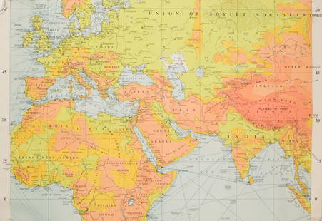
Sold2019Rare 1st ed. 1847 ethno map of Europe/AsiaA large full color map of Europe and Asia showing the ethnographic distribution of people. Includes an accompanying chart. From the first comprehensive physical atlas of the world. This map comes fromSee Sold Price
Sold20181900 HUGE Folding Color Street Map of London 70001900 HUGE Folding Color Street Map of London 7000 Streets Visitors Travel Guide A large, color indicator map of London from the early 20th-century. This map is bound in a hardcover binding and pairedSee Sold Price
Sold2018Air France. Large World Map Airways Route Poster.Masse, Jean. Air France. Large World Map Airways Route Poster. Paris: R. Graindorge/Perceval, ca. 1961. Color map of the world detailing the airline's routes. Linen backed. 45 ½ x 81". Small browSee Sold Price
Sold2018Untitled. [the World On Mercator's Projection]Title/Content of Map: Untitled. [the World On Mercator's Projection] Date Printed: 1920 ca. Cartographer: BARTHOLOMEW, JOHN & SON Size: 49.75x73 Full color gauze back dissected folding map. Folds intoSee Sold Price
Sold2018Rand, McNally & Co.'S New Business Atlas Map of BostonTitle: Rand, McNally & Co.'S New Business Atlas Map of Boston Date: 1909 ca. Cartographer: RAND, MCNALLY & CO. Size: 26 X 19 Large full color city plan with two insets: Environs of Boston and BusinessSee Sold Price
Sold2023MAP, Malta, TirionMalta. Isaac Tirion, Nieuwe Kaart van't Eiland Maltha met Gozo en Comino..., from Nieuwe en Beknopte Hand Atlas, 1761 (dated). Hand Color. Handsome, large map of the Maltese Islands with superb detailSee Sold Price
Sold2022WW2 Army MapsA collection of (8) WW2 U.S. Army Map Service maps of the world. Large, in vivid color.See Sold Price
Sold2023Japanese occupation of Hong Kong Island 20-25th December 1941 1957 old mapDescriptionCAPTION PRINTED BELOW PICTURE: 'Hong Kong Island'DATE PRINTED: 1957IMAGE SIZE: Approx 23.5 x 28.0cm, 9.25 x 11 inches (Large); Please note that this is a folding map.TYPE: Vintage color milSee Sold Price
Sold2019MAP - Mexico, Belize & Guatemala. PinkertonMexico, Belize & Guatemala. John Pinkerton, Spanish Dominions in North America Middle Part, 1811 (dated). Hand Color. This large, handsome map covers the southern part of Mexico with the Yucatan peninSee Sold Price
Sold2022MOLL, HERMAN. [The World Described].MOLL, HERMAN. [The World Described]. 18 engraved multiple-sheet folding maps with original outline hand-color (i.e., incomplete; no beaver map, no codfish map). Tall folio, 25x12 inches, period calf bSee Sold Price
Sold2023Spread of civilisation from antiquity to 1940. World on Kite Projection 1947 mapTITLE/CONTENT OF MAP: 'The Home of Mankind' DATE PRINTED: 1947 IMAGE SIZE: Approx 34.5 x 46.0cm, 13.5 x 18 inches (Large); Please note that this is a folding map. TYPE: Vintage colour atlas map CONDITSee Sold Price
Sold2019MAP - Lake Geneva, Switzerland. Mercator/HondiusLake Geneva, Switzerland. Mercator/Hondius, Lacus Lemanus, 1610 (published). Hand Color. Handsome map of Lake Geneva with good detail of surrounding towns and villages. The large compass rose orientsSee Sold Price
Sold2024MAP, France, HomannWestern France. Johann Baptist Homann, Tabula Ducatus Britanniae Gallis le Gouvernemt. General de Bretagne in suos Novem Episcopatus..., 1720 (circa). Hand Color. Large and very detailed chart roughlySee Sold Price
Sold2022Antique Small Globe on Wire Stand, Copr 1909Antique Terrestrial Globe on wire stand. Copyrighted in 1909 by Weber Costello Co. Wear to piece, fading of color from globe. Measures approx 9 x 6 inches. Globe, decor, world map, antique globe, smalSee Sold Price
Sold20191776 map of France by Zatta w/huge marginsReserve Reduced! "Lovely and large double-page copperplate engraved map of France from the most comprehensive world atlas produced in Italy in the 18th century. Original hand-color in outline with lovSee Sold Price
Sold2018Africa.- Arrowsmith (Aaron) Africa, large folding mapAfrica.- Arrowsmith (Aaron) Africa, large folding map of the continent, with decorative allegorical title cartouche lower left with lions, elephants and Egyptian artefacts, and dedication upper right,See Sold Price
7 days LeftJasper52l'Arménie, la Géorgie et la Daghistan Caucasus. SANTINI/RIZZI-ZANNONI 1784 map$120
7 days LeftJasper52Turquie Européenne. Turkey in Europe. Balkans Greece Aegean. VAUGONDY 1755 map$100
7 days LeftJasper52The Baltic or East Sea, including Gulfs of Botnia & Finland FADEN/NEALE 1803 map$160
Jun 12Dan Morphy AuctionsPHELPS’S TRAVELERS GUIDE THROUGH THE UNITED STATES; CONTAINING UPWARDS OF SEVEN HUNDRED$1,000
11 hrs LeftHunt and Peck Estate Services, Inc.1867 United States General Land Office "Rapport af Chefen fur Land-Kontoret i Furenta Saterna."$200
7 days LeftJasper52Scandinavia physical mountains fjords glaciers. Sweden Norway. STANFORD 1904 map$20
7 days LeftJasper52Scandinavia physical mountains fjords glaciers. Sweden Norway. STANFORD 1904 map$20
7 days LeftJasper52Scandinavia physical mountains fjords glaciers. Sweden Norway. STANFORD 1896 map$25


![Large color map of Alaska coal mine claims 1909: Heading: (Alaska) Author: Stoner, S.N., & A. Kennedy, compilers Title: Map of Certain Coal Claims in the Kayak District Alaska - Clarence Cunningham Agent... Place Published: [Washington, D.C.] Publis](https://p1.liveauctioneers.com/642/280725/147901703_1_x.jpg?height=310&quality=70&version=1678135933)


![Untitled. [the World On Mercator's Projection]: Title/Content of Map: Untitled. [the World On Mercator's Projection] Date Printed: 1920 ca. Cartographer: BARTHOLOMEW, JOHN & SON Size: 49.75x73 Full color gauze back dissected folding map. Folds into](https://p1.liveauctioneers.com/5584/120869/61529702_1_x.jpg?height=310&quality=70&version=1524613752)


![MOLL, HERMAN. [The World Described].: MOLL, HERMAN. [The World Described]. 18 engraved multiple-sheet folding maps with original outline hand-color (i.e., incomplete; no beaver map, no codfish map). Tall folio, 25x12 inches, period calf b](https://p1.liveauctioneers.com/199/251723/130782476_1_x.jpg?height=310&quality=70&version=1655133895)


