Sold20231758 Map Chart of World TradewindsAn Accurate Chart of the World with the New Discoveries....Tradewinds.., by Thomas Kitchin, 1758. Large folding map, measures 17 x 13", Condition issues including creasing and repaired breaks at foldsSee Sold Price
Sold2018Moll: Antique Map of World Trade Winds, 1746Title/Content of Map: World Trade Winds by Moll Date Printed: 1746 Cartographer: Thomas Salmom & Herman Moll Material/Medium: Paper Size: 20 1/2" x 9 1/4" Copperplate engraved. Published in London inSee Sold Price
Sold2022AJ Nystrom 2-Sided Chalkboard School Map, US & WorldLarge AJ Nystrom Roll Up 2 Sided Chalkboard Classroom Map Chart, US & World. Wonderful chart has maps of the United States and the World outlined in yellow on a black chalkboard backing. From the RoyaSee Sold Price
Sold2023Perry, Matthew 1856 Large Map. Chart of the World. Track of the U.S Steam Ships"Chart of the World showing the Track of the U. S. Steam Frigates Mississippi, Susquehanna, and Powhatan" Large Folio Lithograph Map Published 1856, Washington for "Narrative of the Expedition of an ASee Sold Price
Sold2023Thomson, John (Pub) 1825 Map. Chart of the WorldCopper Engraved Map Published 1825 by John Thomson, Edinburgh for "The Edinburgh School Atlas" by N. R. Hewitt. Maps Engraved by Hewitt. Original Outline Hand Colour. Rare. Paper Size: 10.5 x 8 inch (See Sold Price
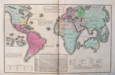
Sold2021Thomson, John (Pub) 1825 Map. Chart of the WorldCopper Engraved Map Published 1825 by John Thomson, Edinburgh for "The Edinburgh School Atlas" by N. R. Hewitt. Maps Engraved by Hewitt. Engraved Vignette in corner. Original Outline Hand Colour. RareSee Sold Price
Sold2023Russell & Barclay 1832 Hand Col Map. Chart of the WorldHand Colored Steel Engraved Map Published 1823-40, by Fisher & Son, "A Complete Atlas of the World" by John Russell et al. A Very Rare Work which is compiled from the same plates used in different ediSee Sold Price
Sold2023Russell & Barclay C1825 Antique Map. Chart of the World (On Mercator Proj.)Copper Engraved Map Published C1825., by Fisher & Son, "A Complete Atlas of the World" by John Russell et al. The companion Atlas to "A Complete and Universal English Dictionary" by James Barclay. PapSee Sold Price
Sold2019Chart of the World, On Mercators ProjectionTitle/Content of Map: Chart of the World, On Mercators Projection Date: 1815 ca. Cartographer: WYLD/HEWETT Size: 11.4Height - 17.4Width Publisher: JOHN THOMPSON & CO. Only named place in Mid-MississipSee Sold Price
Sold2017Chart of the World On Mercators Projection, 1796Map: Chart of the World On Mercators Projection Maker: Thomas & Andrews, Morse/Doolittle (Sculp) Publisher: Boston, 1796 Size: Quarto - 7.30 H x 10.00 W Inches Small map of the world. Shows LouisianaSee Sold Price
Sold2022Chart of the World on Mercator’s Projection, fromTitle/Content of Map: Chart of the World on Mercator’s Projection Date Printed: 1796 Cartographer: Thomas & Andrew Material/Medium: Engraving Size: 8 1/4 x 11" Description: Rare map by Isaiah ThomasSee Sold Price
Sold2017Thomson: Antique World Map, Mercator's Projection, 1814Map: Chart of the World on Mercator's Projection Cartographer: Thomson Place & Date: Edinburgh / 1814 Size: 20" x 17 3/4" Condition: b&w; overall age toning; browning along centerfold; two small, repaSee Sold Price
Sold20231732 H Moll New Map of the Whole World & Tradewinds1732 H Moll New Map of the Whole World with the Tradewinds. Framed, image 8 1/2 x 11 in acid free matt. Hand coloring in map.See Sold Price
Sold2017Chart of the World on Mercators ProjectionCirca 1796 Lot of 2 Antique World Maps; Titles: "Chart of the World on Mercators Projection" (Doolittle, sculp.) Approximate size: 11" x 8-3/8". "Map of the World from the best Authorities" (DoolittleSee Sold Price
Sold20181758 Bellin Chart of the Flags of Sea-Going Nations --Title/Content of Map: 1758 Bellin Chart of the Flags of Sea-Going Nations -- Tableau des Pallions que la Pluspart des Nations Arborent a la Mer Date Printed: 1758, Paris Cartographer: J Bellin Size: 1See Sold Price
Sold20181874 McNally Chart of World Mountain Ranges and RainTitle/Content of Map: 1874 McNally Chart of World Mountain Ranges and Rain Fall Patters -- Chart of the Highlands & Lowlands of the Earth, Principal Volcanoes and Isothermal Lines Date Printed: 1874 cSee Sold Price
Sold20211835 Smith World Map -- A Chart Exhibiting the ActualTitle: 1835 Smith World Map -- A Chart Exhibiting the Actual and Comparative Size of each Country, Nation, or Kingdom; its Population as a Whole and to a Square Mile. Also the Different States of SociSee Sold Price
Sold20191859 Beeton Chronological Chart with World Map -- AnTitle/Content of Map: 1859 Beeton Chronological Chart with World Map -- An Historical Chronological Chart with inset of The World in Mercators Projection Date: 1859 c., London Cartographer: S Beeton SSee Sold Price
Sold2024World Map - Course of Trade Winds Map - Indian Ocean - Atlantic Ocean - from "Histoire Generale deHand-coloured Historic Map "Representation du Cours ordinaire des Vents de Traverse qui regnent le long des Cotes dans la Mer Atlantique & Celle des Indes" charging the course of the trade winds in thSee Sold Price
Sold20201898 Rand McNally Chart of World Flags -- [World Flags]Title/Content of Map: 1898 Rand McNally Chart of World Flags -- [World Flags] Cartographer: Rand McNally Year/Place: 1898, Chicago Size: 12.5 X 9.2 in. This is a very nice chart of 60 world flags, orgSee Sold Price
Sold2017Smith: Antique Map of the World, 1835Map: 1835 Smith World Map -- A Chart Exhibiting the Actual and Comparative Size of each Country, Nation, or Kingdom; its Population as a Whole and to a Square Mile. Also the Different States of SocietSee Sold Price
Sold2020The Second World WarOne of the most comprehensive accounts of the Second World War. Contains maps, charts, copies of correspondence, lists of meeting and a vast array of relative information." Publishers black cloth withSee Sold Price
Sold2022(MANUSCRIPT MAP.) A. Rogers. A Chart of the World According to Mercator's Projections.(MANUSCRIPT MAP.) A. Rogers. A Chart of the World According to Mercator's Projections. Ink and watercolor on four joined sheets of "Potts & Reynolds" watermarked laid paper. 25x31½ inches overallSee Sold Price
Sold20223 PC. FRAMED WORLD MAPS3 PC. FRAMED WORLD MAPS: Comprising; 1- A reduced scale world map based on Mercator's map of 1569. 1- 18th-century hand-colored, A New Map of the Whole World with the Tradewinds According To The LatesSee Sold Price
6 days LeftHunt and Peck Estate Services, Inc.William Hole "A Description of the land of Gosen, and Moses passage though the Deserts"$50
6 days LeftHunt and Peck Estate Services, Inc.Chart Of The World According To Mercators Projection Showing Tracks & Discoveries Of Capt. Cook$140
1 day LeftTrillium Antique Prints & Rare BooksMitchell's A New Universal Atlas.. - Volume with 73 Maps$1,000(1 bid)
5 days LeftJasper521753 Prevost Map of Pacific Wind Currents -- Representation du Cours ordinaire des Vents de Traverse$85
Featured6 days LeftJasper52The Bahamas, Cuba & Bermuda "or Summer Islands". THOMSON 1817 old antique map$180
6 days LeftJasper52Cuba, the Bahamas & Bermuda "or Summer Islands". Turks & Caicos THOMSON 1830 map$160
6 days LeftJasper52Central America Caribbean Gulf of Mexico chart Ports lighthouses LARGE 1918 map$45
Featured6 days LeftJasper52HISPANIOLA. Ocean current directions 1889. Cuba Puerto Rico. USCGS 1889 map$20
5 hrs LeftRapid Estate Liquidators and Auction GalleryVintage Cricket Gillette World Map Lighter Holder$10


![1898 Rand McNally Chart of World Flags -- [World Flags]: Title/Content of Map: 1898 Rand McNally Chart of World Flags -- [World Flags] Cartographer: Rand McNally Year/Place: 1898, Chicago Size: 12.5 X 9.2 in. This is a very nice chart of 60 world flags, org](https://p1.liveauctioneers.com/5584/173638/87405912_1_x.jpg?height=310&quality=70&version=1594766493)


