Sold2022ANTIQUE PRINTED MAP BY SIR JOHN BARROW, London 1797. A chart on Mercator's Projection containing theANTIQUE PRINTED MAP BY SIR JOHN BARROW, London 1797. A chart on Mercator's Projection containing the Track and surroundings of the Lion, the Hindostan and Tenders, from Turon-Bay in Cochin-China to thSee Sold Price
Sold2023General Chart on Mercators Projection. World. Cook's route. PAYNE 1798 old mapTITLE/CONTENT OF MAP: 'General Chart on Mercators Projection' DATE PRINTED: 1798 IMAGE SIZE: Approx 18.0 x 25.0cm, 7 x 9.75 inches (Medium) TYPE: Antique copperplate engraved map with original hand coSee Sold Price
Sold2024Rapkin, John 1860 Antique Map. World on Mercators ProjectionSteel Engraved Map Published 1860 by The London Printing & Published Company, London for "The Royal Dictionary-Cyclopedia for Universal Reference" by Thomas Wright. Drawn & Engraved by John Rapkin. FoSee Sold Price
Sold2019Walker, John 1795 Map of the World on Mercators Proj."General Chart on Mercators Projection" Copper Engraved Map Published 1795, London for "Elements of Geography, and of Natural and Civil History" by John Walker. Centre fold as published. Paper Size: 1See Sold Price
Sold2020World.- Purdy (John, hydrographer) A Chart of theWorld.- Purdy (John) A Chart of the World, on Mercator's Projection; with the Tracks of the more Distinguished Modern Navigators. Regulated throughout, according to the best Scientific Determinations,See Sold Price
Sold2021History of the World by Sir Walter Ralegh 1614 1stThe History of the World In Five Books by Sir Walter Ralegh (Raleigh). 1614. At London Printed for Walter Burre. 669 pp. Includes engraved title page; frontispiece and 8 maps with Chronological TableSee Sold Price
Sold2022Speed, John - Keere, Pieter van den A Prospect of the Most Famous Parts of the WorldSpeed, John - Keere, Pieter van den A Prospect of the Most Famous Parts of the World London: Printed by M.F. for William Humble, 1646. Oblong 8vo, 20 full-page engraved maps, bound with [England, WaleSee Sold Price
Sold2018Encyclopaedia Britannica, 1773 edition[A Dictionary of Arts and Sciences] by a Society of Gentlemen in Scotland, London: Printed for John Donaldson, 1773, three volumes (complete), illustrated with one hundred and sixty copperplates, someSee Sold Price
Sold2022Churchill's Voyages, Six Volumes[A Collection of Voyages and Travels, some now first Printed from Original Manuscripts, others now first Published in English...], ed. Awnsham and John Churchill, London: Printed by Assignment from MeSee Sold Price
Sold20211740 WOMAN's SUPERIOR EXCELLENCE OVER MAN1740 WOMAN's SUPERIOR EXCELLENCE OVER MAN: IN ANSWER TO MAN SUPERIOR TO WOMAN London : printed for John Hawkins, 1740. Presumed first Edition. For a Nearly 300 year old book its in pretty good shape.See Sold Price
Sold2022Stirling-Maxwell, Sir William (publisher) - Vesalius, Andreas Tabulae anatomicae sexStirling-Maxwell, Sir William (publisher) - Vesalius, Andreas Tabulae anatomicae sex Six anatomical tables. London: privately printed for Sir William Stirling-Maxwell, 1874. Large folio, engraved presSee Sold Price
Sold2022Stirling-Maxwell, Sir William (publisher) - Vesalius, Andreas Tabulae anatomicae sexStirling-Maxwell, Sir William (publisher) - Vesalius, Andreas Tabulae anatomicae sex Six Anatomical Tables of Andrew Vesalius. London: privately printed for Sir William Stirling-Maxwell, 1874. Large fSee Sold Price
Sold2022Stirling-Maxwell, Sir William - Vesalius, Andreas Tabulae anatomicae sexStirling-Maxwell, Sir William - Vesalius, Andreas Tabulae anatomicae sex Six anatomical tables. London: privately printed for Sir William Stirling-Maxwell, 1874. Large folio, engraved presentation pagSee Sold Price
Sold2023[MAP]. FRY & JEFFERSON. A Map of the Most Inhabited Part of Virginia. 1775. FIRST PRINTED MAP OF[MAPS & ATLASES]. FRY, Joshua (1699-1754) and Peter JEFFERSON (1708-1757). A Map of the Most Inhabited Part of Virginia containing the whole Province of Maryland with Part of Pensilvania, New JersSee Sold Price
Sold2021248 OZ Antique John Paul & Co Sterling Silver FlatwareWeighs approximately 248 standard ounces. Antique John Paul & Co Sterling Silver Flatware. Having British hallmark for the city of London date letter K for 1905 and maker's mark GJDF for George JacksoSee Sold Price
Sold2022Sir John Dean Paul, Oil on Canvas Melbourne House(English, 1775-1852) depicting Melbourne House and the Banqueting Hall, Whitefall, c. 1750, with label verso Overall: 22"h x 28"w Sight: 17-1/2"h x 23-1/2"w Provenance: David Messum Fine Art, London:See Sold Price
Sold2022(PICTORIAL MAPS.) John Diakoff; G. Primakoff; and P. Sergeeff. Map of China.(PICTORIAL MAPS.) John Diakoff; G. Primakoff; and P. Sergeeff. Map of China. Enormous chromolithographed map of China with profuse pictorial illustration, inset charts, reference tables, and scenic viSee Sold Price
Sold20201761 MAP OF NORTH AMERICA BY ROCQUE18th century map GENERAL MAP OF NORTH AMERICA 1754-1761 by John Rocque, London by A. Drury, 2 part map, 35.5 x 36 inches, good condition.See Sold Price
Sold2022Pamphlets Collection of plays and tracts, 17th-19th centuryPamphlets Collection of plays and tracts, 17th-19th century including: [Vanbrugh, Sir John]. The Provok'd Wife: a Comedy as it is acted at the New Theatre in Little Lincolns-Inn-Fields. London: for RiSee Sold Price
Sold2022PETAVIUS (Dionysius) The History of the World: Or, an Account of Time. London: John Streater 1659,PETAVIUS (Dionysius) The History of the World: Or, an Account of Time. London: John Streater 1659, small folio, folding world map (loose with creases), lacking portrait, contemporary calf, worn with fSee Sold Price
Sold2019Antique 17c English Long Case Grandfather ClockAntique 17th century English tall case grandfather clock. Crafted by John May London who was admitted as a brother of the clock makers company of London in the year 1692. Features ornate marquetry inlSee Sold Price
2023[Prints] Audubon, John J(ames). White-headed Eagle[Prints] Audubon, John J(ames). White-headed Eagle London: John J. Audubon, (1836). Hand-colored engraving with aquatint and etching, on J. Whatman watermarked paper, dated 1836. Engraved, printed, anSee Sold Price
Sold2022Marine Chronometer John R Arnold, London No 487Marine Chronometer, Ship clock, John R. Arnold, London, No 487, 8 day, instrument tag from US Navy. Mahogany case with inlaid brass corners. Winding indicator, Silvered dial, Fusee movement, running cSee Sold Price
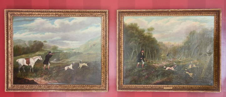
Sold2021Pair of Oil Paintings by Samuel J E JonesPair of Antique 19th C Oil Paintings by Samuel J E Jones. Each of a hunting scene, oil on canvas, framed and signed. Samuel John Egbert Jones, (1797 - 1861) was active/lived in United Kingdom. Each meSee Sold Price
Featured2024Jasper521738 RUSSIA SIBERIA & GREAT TARTARY Description illustrated ANTIQUE in ENGLISHSee Sold Price
1818 AuctioneersPolar Travel. North-West Passage. Two titles: The Search for Franklin. A Narrative of the American£60(6 bids)
4 days LeftTrillium Antique Prints & Rare BooksCatesby, Folio - Green Turtle with Turtle Grass. 2-38$200
4 days LeftTrillium Antique Prints & Rare BooksCatesby, Folio - Cecropia Moth with Custard Apple. 2-86$200
4 days LeftTrillium Antique Prints & Rare BooksCatesby, Folio - Nuthatch & Small Nuthatch with Highland Willow Oak. 1-22$200
Jun 06Freeman's | HindmanSHELLEY, Percy Bysshe (1792-1822). Posthumous Poems. London: John and Henry L. Hunt, 1824.$250
326 Lots AwayJasper521702 BIBLE in ENGLISH CLASPS METAL DECORATIONS RARE OLD & NEW TESTAMENT antique$750
466 Lots AwayJasper521732 HISTORY of ENGLAND 2 volumes by RAPIN de THOYRAS antique ILLUSTRATED FOLIOS$460
332 Lots AwayJasper521816 MAP NORTHERN PART OF RUSSIA or MUSCOVY in EUROPE copper engraving ANTIQUE$35
May 30Antiques Online AuctionsVintage Texas 1845 Map Printed in 1986, Compiled by John Davis$35(4 bids)


![Encyclopaedia Britannica, 1773 edition: [A Dictionary of Arts and Sciences] by a Society of Gentlemen in Scotland, London: Printed for John Donaldson, 1773, three volumes (complete), illustrated with one hundred and sixty copperplates, some](https://p1.liveauctioneers.com/33/130011/66112530_1_x.jpg?height=310&quality=70&version=1540499574)
![Churchill's Voyages, Six Volumes: [A Collection of Voyages and Travels, some now first Printed from Original Manuscripts, others now first Published in English...], ed. Awnsham and John Churchill, London: Printed by Assignment from Me](https://p1.liveauctioneers.com/33/260783/135836332_1_x.jpg?height=310&quality=70&version=1662513112)


![[MAP]. FRY & JEFFERSON. A Map of the Most Inhabited Part of Virginia. 1775. FIRST PRINTED MAP OF: [MAPS & ATLASES]. FRY, Joshua (1699-1754) and Peter JEFFERSON (1708-1757). A Map of the Most Inhabited Part of Virginia containing the whole Province of Maryland with Part of Pensilvania, New Jers](https://p1.liveauctioneers.com/197/305583/163286504_1_x.jpg?height=310&quality=70&version=1697143109)


![Pamphlets Collection of plays and tracts, 17th-19th century: Pamphlets Collection of plays and tracts, 17th-19th century including: [Vanbrugh, Sir John]. The Provok'd Wife: a Comedy as it is acted at the New Theatre in Little Lincolns-Inn-Fields. London: for Ri](https://p1.liveauctioneers.com/94/251108/130829086_1_x.jpg?height=310&quality=70&version=1655281539)


![[Prints] Audubon, John J(ames). White-headed Eagle: [Prints] Audubon, John J(ames). White-headed Eagle London: John J. Audubon, (1836). Hand-colored engraving with aquatint and etching, on J. Whatman watermarked paper, dated 1836. Engraved, printed, an](https://p1.liveauctioneers.com/65/295053/156641149_1_x.jpg?height=310&quality=70&version=1688656790)


![[FABLES]. A group of 3 works, comprising: (1 of 1)](https://p1.liveauctioneers.com/197/329405/177652680_1_x.jpg?height=282&quality=70&version=1715364568)


