Sold2020James Imray Blueback Chart of the English ChannelEnglish Channel London Published by James Imray and Son, 1893, corrected to 1894, with pencil writing changes throughout. Rolled, Blue Back Marine Navigation Chart measures 72" x 41" Estate-found andSee Sold Price
Sold20221894 NAUTICAL CHART OF IRELANDAntique nautical chart with heavy blue paper backing - Chart #18 West Coast of Ireland 1894 (Part II of Navigating Round Ireland). Published in London by James Imray & Son 1894. 34.5 x 50 inches, hasSee Sold Price
Sold2017Rollinson: Correct Chart of the English Channel, 1796Map: A Correct Chart of the English Channel Publication Date: 1796-09-01 Maker: SPOTSWOOD AND NANCREDE, ROLLINSON. Publisher: SPOTSWOOD AND NANCREDE Size: Octavo – 7.10 H x 7.25 W Inches Malham's ChSee Sold Price
Sold2019English Nautical Chart Magnifying Lens w BrassEnglish nautical chart lens / double magnifying lens, with brass collar mount. 3" H x 5.75" diameter. Minor repaired chip at edge.See Sold Price
Sold2018Antique Sea Chart Map of English Channel, 1914Title/Content of Map: 'The English Channel; Inset Newport; Dover; Calais; Tilbury; Brest; Cherbourg; Le Havre; Plymouth Sound; Southampton; Portsmouth; London Docks' sea chart. Ports lighthouses mailSee Sold Price
Sold20191784 Chart of the English Channel France Spain“A Chart of the English Channel with the Coasts of France Spain and Portugal”, printed for Harrison and Co., 1784. Folding, measures 16.5 x 9.5”. Reserve: $20.00 Shipping: Domestic: Flat-rate ofSee Sold Price
Sold2019British Isles.- The Channel.- Searle (Richard William)British Isles.- The Channel.- Searle (Richard William) A correct Chart of the English Channel from the No.Foreland to [...] Brest on the coast of France, sea chart of the Channel with four inset mapsSee Sold Price
Sold20191758 Kitchin Map of the English Channel -- A Chart ofTitle/Content of Map: 1758 Kitchin Map of the English Channel -- A Chart of the English Channel with Adjacent Coasts of England and France Date: 1758, London Cartographer: T Kitchin Size: 7.1 X 10.1 iSee Sold Price
Sold2022Antique Map of Europe - Map of English Channel - Coasts of France, Spain - BaylyAntique map of a chart of the English Channel, with the coasts of France, Spain and Portugal from "The Geographical Magazine; or A New Copious, Compleat, and Universal System of Geography…By WilSee Sold Price
Sold2022Nautical chart of Acapulco by the English pirate Anson, 1749Title: Nautical chart of Acapulco by the English pirate Anson, 1749 Date/Period: 1749 Materials: Copper plate engraved Size: 10 x 7 1/4 “ Nautical chart of the port of Acapulco, Mexico. By the ESee Sold Price
Sold2023Nautical Chart of Manila by the English pirate Anson. 1749Title: Nautical Chart of Manila by the English pirate Anson. 1749 Date/Period: 1749 Materials: Copper plate engraved Size: 10 x 9 3/4” Nautical chart of Manila, Philippines. Showing the city andSee Sold Price
Sold2024Bosporus & Constantinople 1839 British Admiralty Nautical ChartScarce 1839 original British Admiralty Nautical Chart for the Bosporus or Channel of Constantinople. Published according to Act of Parliament at the Hydrographic Office of the Admiralty May 1st 1839.See Sold Price
Sold2022Nautical chart of Petatian near Acapulco by the English pirate Anson, 1749Title: Nautical chart of Petatian near Acapulco by the English pirate Anson, 1749 Date/Period: 1749 Materials: Copper plate engraved Size: 15 1/2 x 10” Nautical chart of Petatian, near Acapulco,See Sold Price
Sold2022Nautical chart of Coiba island, Panama, by the English pirate Anson. 1749Title: Nautical chart of Coiba island, Panama, by the English pirate Anson. 1749 Date/Period: 1749 Materials: Copper plate engraved Size: 15 1/2 x 10” Nautical chart of the east end of Quibo (CoSee Sold Price
Sold2022Nautical chart of the Pacific Ocean, showing the route of the famous Spanish treasure’ManilaTitle: Nautical chart of the Pacific Ocean, showing the route of the famous Spanish treasure’Manila Galleons’, by the English pirate Anson. 1749 Date/Period: 1749 Materials: Copper plateSee Sold Price
Sold2024MAP, English Channel, DanckertsEnglish Channel. Theodorus Danckerts, Novissima et Accuratissima Canalis Inter Angliae et Galliae Tabula cum Omnibus suis Portibus, Arenis et Profundis, 1695 (circa). Hand Color. Magnificent chart ofSee Sold Price
Sold2023Scarce sea chart of the area from Galicia to the southern part of the English Channel and Ireland,Scarce sea chart of the area from Galicia to the southern part of the English Channel and Ireland, oriented with East at the top. Includes a decorative cartouche, compass rose, sailing ships, rhumblinSee Sold Price
Sold2022Nautical chart of the attack by five ships on Acapulco, by the English pirate Anson. 1749Title: Nautical chart of the attack by five ships on Acapulco, by the English pirate Anson. 1749 Date/Period: 1749 Materials: Copper plate engraved Size: 15 1/2 x 10” Nautical chart of the attacSee Sold Price
Sold2023Antique Nautical Chart of the Philippines: Manila Galleons Route by English Pirate George Anson,Title: Antique Nautical Chart of the Philippines: Manila Galleons Route by English Pirate George Anson, 1749 Date/Period: 1749 Materials: Copper plate engravedSize: 21 1/4 x 16 3/4”. Step into tSee Sold Price
Sold2022Nautical chart of Juan Fernandez island. (Robinson Cruseo is) by the English pirate Anson, 1749Title: Nautical chart of Juan Fernandez island. (Robinson Cruseo is) by the English pirate Anson, 1749 Date/Period: 1749 Materials: Copper plate engraved Size: 15 1/2 x 10” Nautical chart of JuaSee Sold Price
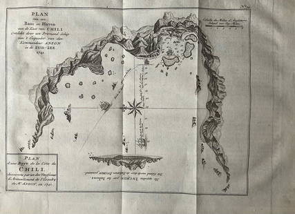
Sold2022Nautical chart of a unidentified bay in Chile. By the English pirate Anson 1749Title: Nautical chart of a unidentified bay in Chile. By the English pirate Anson 1749 Date/Period: 1749 Materials: Copper plate engraved Size: 13 1/2 x 9 3/4” Nautical chart of a unidentified BSee Sold Price
Sold2023Nautical chart of Chequetan harbor near Acapulco, by the English pirate AnsonTitle: Nautical chart of Chequetan harbor near Acapulco, by the English pirate Anson Date/Period: 1749 Materials: Copper plate engraved Size: 15 1/2 x 10" Nautical chart of Chequetan or Seguaaneo, harSee Sold Price
Sold2023Antique Nautical Chart of Juan Fernandez Island: Northeast Side by English Pirate George Anson,1749Title: Antique Nautical Chart of Juan Fernandez Island: Northeast Side by English Pirate George Anson,1749 Date/Period: 1749 Materials: Copperplate engraved Size: 15 1/2 x 10” Explore the legendSee Sold Price
Sold2020Lyttleton, George 1810 Map of The English Channel"Chart of the British Channel with the opposite Coast of the United Kingdom, and the Republic of France" Copper Engraved Map Published 1810, London for "The History of England..." by George Courtney LSee Sold Price
2 days LeftActivity Auctions1894 English Birmingham Sterling Silver Highly Decorative Box No Mono$150
Jun 29Thomaston Place Auction GalleriesFOLLOWER OF JAN ABRAHAMSZ BEERSTRAATEN (NETHERLANDS, 1622-1666)$2,500
6 days LeftFreeman's | HindmanWATSON, George R.. "Glenn Martin to Test-Fly "Pusher" Curtis Single Engine". C. 1920-1929 (printed$100
5 days LeftJasper52Southern Africa Cape of Good Hope-Madagascar ADMIRALTY sea chart 1935 (1955) map$60
5 days LeftJasper52South Namibia coast. Walvis Bay-Orange River ADMIRALTY sea chart 1881 (1954) map$85
2 days LeftKCM Galleries1870 Philip Gilbert Hamerton The Hotel De Beauchamp, Autun etching signed$100
Jun 13TheRedFinch AuctionsThe Queen of the Fishes. With 12 woodcuts by L. Pissarro, one proof of woodcut, and an extra print$7,000
6 days LeftFreeman's | Hindman[ERAGNY PRESS]. RONSARD, Pierre de. Abregé de l'Art Poetique François. 1903. LIMITED$100
6 days LeftFreeman's | Hindman[ENGLISH & CONTINENTAL MANUSCRIPTS]. EDWARD VIII, Duke of Windsor. Autograph letter letter signed to$250


![British Isles.- The Channel.- Searle (Richard William): British Isles.- The Channel.- Searle (Richard William) A correct Chart of the English Channel from the No.Foreland to [...] Brest on the coast of France, sea chart of the Channel with four inset maps](https://p1.liveauctioneers.com/5458/156131/78785342_1_x.jpg?height=310&quality=70&version=1574849334)


![[ERAGNY PRESS]. RONSARD, Pierre de. Abregé de l'Art Poetique François. 1903. LIMITED (1 of 1)](https://p1.liveauctioneers.com/197/329395/177650295_1_x.jpg?height=282&quality=70&version=1715364962)

![[ENGLISH & CONTINENTAL MANUSCRIPTS]. EDWARD VIII, Duke of Windsor. Autograph letter letter signed to (1 of 2)](https://p1.liveauctioneers.com/197/329395/177650345_1_x.jpg?height=282&quality=70&version=1715364962)


