Sold2024Pictorial Map of Hollywood and Vicinity / Hollywood Film Ca...Pictorial Map of Hollywood and Vicinity / Hollywood Film Capital of the World. 1947. Los Angeles: Lowell E. Jones. Lithograph. Rare pictorial map of Hollywood with map of California on verso. PublisheSee Sold Price
Sold2020Rare pictorial map of Oakland and S.F. BayHeading: (California - Oakland, San Francisco, etc.) Author: Lundy, Fred Title: San Francisco Bay. (with) part of San Francisco and Oakland Place Published: Oakland, CA Publisher:Tribune Publishing CoSee Sold Price
Sold2021Rare pictorial tourist map of Imperial Valley, Cal.Heading: (California - Imperial Valley) Author: Pique, Ethel Title: Points of Interest in Imperial Valley, Land of Sunshine & Romance Place Published: El Centro, Calif. Publisher:El Centro Chamber ofSee Sold Price
Sold2020Rare pictorial map of Peking 1936Heading: (China - Beijing) Author: Dorn, Frank Title: A Map and History of Peiping, formerly known as Peking... Place Published: Tienstsin-Peiping Publisher:Peiyang Press, Ltd. Date Published: </See Sold Price
Sold2022RARE PICTORIAL MAP OF CAPE ANN & THE NORTH SHOREMounted to board. Designed by Errol W. Goff for Houghton Mifflin Co Boston MA 1934. 31 3/8 x 36 1/2 inches. Condition: Good. Frame slightly bowed.See Sold Price
Sold2020Small Hand-Colored Map of Nantucket by William SchontzeSmall Hand-Colored Map of Nantucket by William Schontzeler,rare pictorial map of Nantucket in original frame, signed, l.r William Cotton Schontzeler, trained as a draftsman in NY, he owned and workedSee Sold Price
Sold2020Pictorial Map Southern CaliforniaRadio Comedians Map of Southern California. Radio Stations of Los Angeles and Orange County areas. 2nd Quarter, 20th Century. 11 1/2" x 18".See Sold Price
Sold20181938 R Taylor White Pictorial Map of CaliforniaTitle/Content of Map: 1938 R Taylor White Pictorial Map of California -- California Date Printed: 1938, Boston Cartographer: Ruth Taylor White Size: 11.6 x 8.5 in. This is Ruth Taylor White's charmingSee Sold Price
Sold2020Mora, Jo (1876–1947). California. Monterey, CA:Mora, Jo (1876–1947). California. Monterey, CA: Jo Mora Publishing, 1945. A pictorial map of California with numerous colorful illustrations. 25 x 19”. Light dust smudging to margins withSee Sold Price
Sold2020Pierre Duval Nova Mexico Map ca. 1660 CaliforniaPierre Duval (1618-1683), "Nova Mexico," Nuremberg, ca. 1660-1680. This rare map depicts California as an island, based on Sanson's depiction, along with the surrounding areas of Mexico and what is noSee Sold Price
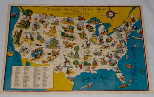
Sold2022Walt Disney Dixon's Mickey Mouse Map of United StatesEarly Disneyana collectible map. Copyright Walt Disney Enterprises 1935. Rare early pictorial map of the United States , richly illustrated with Disney character vignettes in each of the 48 states, MiSee Sold Price
Sold2024RARE HAND-PAINTED MAP, SASKATOON, 1885Saskatoon in 1885 During the Rebellion, mixed media on paper, numbered sites with legend verso, signed lower right, 14" H, 21" W.See Sold Price
Sold2022California Pictorial MapFun Map of Southern California. All-Year Club, c. 1930s. Recreational activities. Santa Barbara, Malibu, Los Angeles, Santa Monica, San Diego. 11" x 11".See Sold Price
Sold2017Pictorial map of Southern CaliforniaHeading: (California) Author: Putnam, Claude G. Title: Southern California's Sunshine Empire and Golden Coast (wrapper title) Place Published: San Bernardino, CA Publisher:Southern California TouristSee Sold Price
Sold20201963 Putnam Pictorial Map of Southern California --Title/Content of Map: 1963 Putnam Pictorial Map of Southern California -- Ride the Roads to Romance along the Gold Coast thru the Sunshine Empire of Southern California Cartographer: C Putnam Year/PlaSee Sold Price
Sold20211950 Putnam Pictorial Map of Southern California --Title: 1950 Putnam Pictorial Map of Southern California -- Ride the Roads to Romance along the Gold Coast thru the Sunshine Empire of Southern California Cartographer: C Putnam Year / Place: 1950, SanSee Sold Price
Sold20211963 Putnam Pictorial Map of Southern California --Title: 1963 Putnam Pictorial Map of Southern California -- Ride the Roads to Romance along the Gold Coast thru the Sunshine Empire of Southern California Cartographer: C Putnam Year / Place: 1963, SanSee Sold Price
Sold2017Putnam: Vintage Pictorial Map of South California, 1963Title/Content of Map: 1963 Putnam Pictorial Map of Southern California -- Ride the Roads to Romance along the Gold Coast thru the Sunshine Empire of Southern California Date Printed: 1963, San BernardSee Sold Price
Sold20211885 California MapAuthor: Cram Title: 1885 California Map Medium: Ink on Paper Dimensions: 13.5"X21.5" Map of California dated 1885. Printed and published by George Cram in Chicago. Part of his World Atlas. Double foliSee Sold Price
Sold20201885 Map of CaliforniaAuthor: Watson Title: 1885 Map of California Medium: Ink on Paper Dimensions: 13.5"X21.5" Map of California dated 1885. Engraved and published by Watson in Chicago. Part of his World Atlas. Double folSee Sold Price
Sold2022Pictorial map of mother lode California & NevadaHeading: (California - Mother Lode) Author: Cormak, Robert Title: Mother Lode Map Incorporating Mother Lodes of California and Nevada, Scenes of the "Romantic Days of Gold" Place Published: Berkeley,See Sold Price
Sold2023Pictorial bird's-eye map of Southern CaliforniaHeading: (California - Southern) Author: Putnam, Claude George, Sr. Title: Ride the Roads to Romance Along the Golden Coast and Thru the Sunshine Empire of Southern California Place Published: No placSee Sold Price
Sold2021MORA, Jo (1876-1947). California / El Dorado of theMORA, Jo (1876-1947). California / El Dorado of the West. Monterey, 1945. Lithograph pictorial map, or “carte,” of California. Numerous cartoonish illustrations of cities and towns, nationSee Sold Price
Sold2022RARE and Important Map of Upper California and Oregon territory. 1846 by MitchellTitle: RARE and Important Map of Upper California and Oregon territory. 1846 by Mitchell Date/Period: 1846 Dimension: 11 1/2 x9" Material: Hand colored engraved Additional Information: Rare only becauSee Sold Price
Jun 23Schilb Antiquarian Rare Books1848 Emory Military Reconnaissance 1ed California MAP Indians Texas New Mexico$2(2 bids)
Jun 23Schilb Antiquarian Rare Books1877 Geology Geography Surveys 1ed Nevada Wyoming Utah George Wheeler US West 2v$1
Jul 11Dan Morphy AuctionsVERY RARE SIGNAL GASOLINE DELIVERY TRUCK PORCELAIN CAB TOPPER SIGN AGS 91.$1,300(1 bid)
BonhamsMARKHAM (CLEMENTS) The Land of Silence: A History of Arctic and Antarctic Exploration, FIRST EDI...£10
Jun 23Schilb Antiquarian Rare Books1855 San Francisco 1st ed California Gold Rush Illustrated MAPS Soule Indians$11(3 bids)


![[Annan, Thomas & Sons] - and A.H. Millar (1 of 1)](https://p1.liveauctioneers.com/94/330664/178342314_1_x.jpg?height=282&quality=70&version=1716466933)


