Sold2022Transport Map of Central Europe. Railways mail routes. LARGE 1959 oldTITLE/CONTENT OF MAP: 'Transport Map of Central Europe' DATE PRINTED: 1959 IMAGE SIZE: Approx 49.5 x 72.0cm, 19.5 x 28.25 inches (Large); Please note that this is a folding map. TYPE: Antique colour mSee Sold Price
Sold2023Baltic Sea sea chart. Ports lighthouses mail routes dockyards. LARGE 1959 mapTITLE/CONTENT OF MAP: 'Central European states - Political' Czechoslovakia includes Carpathian Ruthenia, which it administered until it was occupied and annexed by Hungary in 1939; it was subsequentlySee Sold Price
Sold2022EUROPE & MEDITERRANEAN. Relief. Railways. Shipping routes. BARTHOLOMEW 1912 mapTITLE/CONTENT OF MAP: 'Central Europe and The Mediterranean' DATE PRINTED: 1912 IMAGE SIZE: Approx 33.5 x 44.5cm, 13.25 x 17.5 inches (Large); Please note that this is a folding map. TYPE: Antique colSee Sold Price
Sold2019Gross, Alexander 1920 Mixed Lot of 7 Large MapsIncl Austria, Europe, Europe - Political, Central Europe - Railways, Mediterranean Sea, South Atlantic Ocean, and North Atlantic Ocean. Large Lithograph Maps Published 1920, London for "The Daily TeleSee Sold Price
Sold2024Central Europe with Railways: operating & under construction. SWANSTON 1860 mapCAPTION PRINTED BELOW PICTURE: 'Central Europe with Railways' DATE PRINTED: 1860 IMAGE SIZE: Approx 44.5 x 55.0cm, 17.5 x 21.75 inches (Large); Please note that this is a folding map. TYPE: Antique atSee Sold Price
Sold2022EUROPE. INDUSTRIES. Coal & Iron deposits. British consuls. Railways 1920 mapTITLE/CONTENT OF MAP: 'Central & Western Europe (Industrial)' DATE PRINTED: 1920 IMAGE SIZE: Approx 34.0 x 45.0cm, 13.25 x 17.5 inches (Large) TYPE: Vintage colour map CONDITION: Good; suitable for frSee Sold Price
Sold2024MEDITERRANEAN & BLACK SEAS showing steamship routes & railways 1911 old mapTITLE OF THE MAP: 'The Mediterranean; Inset Canary Islands' DATE PRINTED: 1911 IMAGE SIZE: Approx 27.0 x 51.0cm, 10.75 x 20 inches (Large); Please note that this is a folding map. TYPE: Antique colourSee Sold Price
Sold2023Eastern Europe sea chart Ports Lighthouses mail route Black Sea Baltic 1918 mapTITLE/CONTENT OF MAP: 'Eastern European Ports and Waterways' DATE PRINTED: 1918 IMAGE SIZE: Approx 49.0 x 34.0cm, 19.25 x 13.5 inches (Large) TYPE: Antique colour maritime map chart; Scale 1:20,000,00See Sold Price
Sold2024NORTH & CENTRAL ASIA. Siberia Japan Korea Khiva Bokhara Turkistan 1912 old mapTITLE/CONTENT OF MAP: 'Northern Asia; Central Asia' DATE PRINTED: 1912 IMAGE SIZE: Approx 33.0 x 44.0cm, 13 x 17.25 inches (Large); Please note that this is a folding map. TYPE: Antique colour atlas mSee Sold Price
Sold2024NORTH & CENTRAL ASIA. Siberia Japan Korea Khiva Bukhara Turkistan 1901 old mapTITLE/CONTENT OF MAP: 'Northern Asia; Central Asia' DATE PRINTED: 1901 IMAGE SIZE: Approx 43.0 x 33.0cm, 17 x 13 inches (Large); Please note that this is a folding map. TYPE: Antique colour map CONDITSee Sold Price
Sold2024NORTH & CENTRAL ASIA. Khiva Bukhara Turkistan. Unresolved borders 1898 old mapTITLE/CONTENT OF MAP: 'Northern Asia; Central Asia' DATE PRINTED: 1898 IMAGE SIZE: Approx 42.5 x 32.0cm, 16.75 x 12.5 inches (Large); Please note that this is a folding map. TYPE: Antique colour map CSee Sold Price
Sold2024SOUTH & SOUTH WEST ASIA. Physical. Main railways. BARTHOLOMEW 1952 old mapCAPTION PRINTED BELOW PICTURE: 'South & S.W. Asia, Regional' DATE PRINTED: 1952 IMAGE SIZE: Approx 21.5 x 34.0cm, 8.5 x 13.25 inches (Large) TYPE: Vintage colour map; Scale 1:22,500,000 CONDITION: GooSee Sold Price
Sold2024Eurasia. Europe & Asia political & relief. USSR. Trucial Oman. TIMES 1959 mapCAPTION PRINTED BELOW PICTURE: 'Eurasia' DATE PRINTED: 1959 IMAGE SIZE: Approx 47.5 x 59.5cm, 18.75 x 23.5 inches (Large); Please note that this is a folding map. TYPE: Vintage coloured map CONDITION:See Sold Price
Sold2024USSR Central Asia. Kazakhstan Uzbekistan Turkmeniya Aral Sea. TIMES 1959 mapCAPTION PRINTED BELOW PICTURE: 'U.S.S.R // Central Asia // Kazakhstan // Fergana Basin' DATE PRINTED: 1959 IMAGE SIZE: Approx 48.0 x 60.0cm, 18.75 x 23.75 inches (Large); Please note that this is a foSee Sold Price
Sold2024CENTRAL ASIA. Turkestan & Inner c1885 old antique vintage map plan chartTITLE/CONTENT OF MAP: 'Turkestan and Inner Asia' DATE PRINTED: c1885 IMAGE SIZE: Approx 25.0 x 31.0cm, 9.75 x 12.25 inches (Large); Please note that this is a folding map. TYPE: Antique coloured engraSee Sold Price
Sold2024ASIA. Central Asia and the Indian Frontier 1907 old antique map plan chartCAPTION PRINTED BELOW PICTURE: 'Central Asia and the Indian Frontier' DATE PRINTED: 1907 IMAGE SIZE: Approx 36.5 x 48.5cm, 14.5 x 19 inches (Large); Please note that this is a folding map. TYPE: ColouSee Sold Price
Sold2024Turkestan, or Independent Tartary by Edward Weller. Central Asia 1860 old mapCAPTION PRINTED BELOW PICTURE: Turkestan, or Independent Tartary [including Khiva, Bokhara, Kokan, Kunduz, &c., and the shores of the Caspian and of the Aral Sea,] Central Asia between the Caspian SeaSee Sold Price
Sold202113-Star Civil War Vintage Flag. 63" x 34" light-13-Star Civil War Vintage Flag. 63" x 34" light-weight cotton, stars arranged in a medallion pattern with large central star and stars in each corner. Twill cotton sleeve with rope insert. Four old reSee Sold Price
Sold2022Antique Khotan Tiger Oriental Rug- 4'8'' x 8'8''Antique Khotan Tiger Oriental Rug. Measure 4'8'' x 8'8''. Purple field with large central Tiger, coin and medallion border. Scattered wear with a few small old repairs.See Sold Price
Sold2024Asia c750AD Chin Machin Chen-la Tu-fan Caliphs Empire pilgrim routes 1935 mapCAPTION PRINTED BELOW PICTURE: 'Asia, ca. 750 A.D.' DATE PRINTED: 1935 IMAGE SIZE: Approx 34.5 x 30.0cm, 13.5 x 11.75 inches (Large); Please note that this is a folding map. TYPE: Vintage colour map;See Sold Price
Sold2019A platinum Art Deco 2.7 ct diamond ringThe Platinum ring is set with a large and impressive 2.7 ct old cut diamond(SI2 I-K) Three princess cut diamonds flank the central diamond on each side. weight: 7.4 grams US ring size: 8See Sold Price
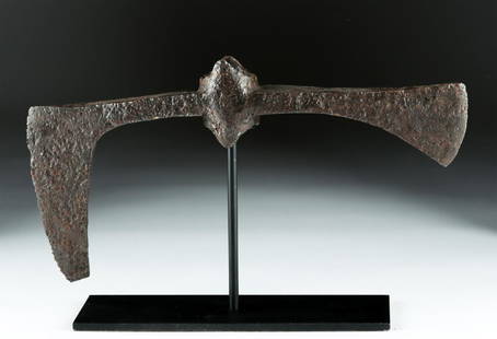
Sold2018Large 7th C. Viking / Anglo-Saxon Iron Broad-Axe HeadNorthern Europe, Viking, Anglo-Saxon, or possibly other Germanic, ca. 7th to 9th century CE. Both magnificent and terrifying, an enormous cast-iron, double-headed broad-axe with a central socketing shSee Sold Price
Sold2018India.- Joseph (Charles) Map of the Grand Trunk RoadIndia.- Joseph (Charles) Map of the Grand Trunk Road from the Karamnassa to the Sutledge, Part Second, from Agra to Ferozepoor, large folding road map of one of the oldest and longest trade routes linSee Sold Price
Sold2022Mitchell's large Mexican-American War map, 1847Heading: Author: Mitchell, Samuel Augustus Title: Map of Mexico, Including Yucatan & Upper California, Exhibiting the Chief Cities and Towns, the Principal Travelling Routes &c. Place Published: PhilSee Sold Price
6 days LeftJasper52SOUTH AMERICA COMMERCIAL.Steamer routes Telegraph cables Railways Canal 1901 map$8
Jun 07Freeman's | Hindman[MORMONS]. MILLROY & HAYES (fl. 1899). Route of the Mormon Pioneers from Nauvoo to Great Salt Lake,$300
7 days LeftPandora AuctionsStylish Vintage Mid-Century Modern Brutalist European 835 Silver & Amethyst Pendant Necklace$25
1 day LeftTrillium Antique Prints & Rare BooksDe Jode, Rare, pub. 1593 - Map of Europe (Nova Totius Europae Tabula)$160(4 bids)
Jun 15Hess Fine AuctionsVery Large Old Master Simon de Chalons Circle Oil on Panel Holy Family Virgin Mary Christ Child$30(3 bids)
7 days LeftPandora AuctionsAntique Art Deco European Sterling Silver & Gemstone Venice Gondola Scene Cigarette Case$200(1 bid)
7 days LeftPandora AuctionsAntique ca. 1880 European 14K Gold & Shell Cameo "Chariot with Putto" Brooch$75
Jun 02Tremont Auctions14K white gold opal and diamond halo ring. Large central opal stone measuring approx. 10.8 x 9.3mm.$150(1 bid)
19 hrs LeftJasper52Large Leaded Crystal Whiskey Decanter with O’mara Old Fashioned Whiskey Glasses$70
3 days LeftArarity AuctionsJules Guerin "Christmas Night, Old Trinity Church, New York City" Antique 1906 Lithograph$25


![Turkestan, or Independent Tartary by Edward Weller. Central Asia 1860 old map: CAPTION PRINTED BELOW PICTURE: Turkestan, or Independent Tartary [including Khiva, Bokhara, Kokan, Kunduz, &c., and the shores of the Caspian and of the Aral Sea,] Central Asia between the Caspian Sea](https://p1.liveauctioneers.com/5584/329387/177649405_1_x.jpg?height=310&quality=70&version=1715717898)


![[MORMONS]. MILLROY & HAYES (fl. 1899). Route of the Mormon Pioneers from Nauvoo to Great Salt Lake, (1 of 2)](https://p1.liveauctioneers.com/197/329395/177650560_1_x.jpg?height=282&quality=70&version=1715364962)


