Sold2024De Jode, Rare, pub. 1593 - Map of Germany (Germaniae Totius, Nostrae Europae celeberrimae regionis,This truly significant map is from one of the rarest atlases ever published, Gerard and Cornelis de Jode's Speculum orbis Terrae. The work was published in Antwerp in 1593 by Arnold Coninx for the widSee Sold Price
Sold2024De Jode, Rare, pub. 1593 - Map of the Holy Land (Descriptio Et Situs Terrae Sanctae Alio NomineThis map of the Holy Land is entitled Descriptio Et Situs Terrae Sanctae Alio Nomine Palestina Multis Preclaris Historys Et Miraculis Utriusque Testamenti A Christo Salvatore nobilitata. The map is beSee Sold Price
Sold2024De Jode, Rare, pub. 1593 - Map of Kingdom of Napoli, Italy (Neapolitani Regni exacta ac diligensThis truly significant map is from one of the rarest atlases ever published, Gerard and Cornelis de Jode's Speculum orbis Terrae. The work was published in Antwerp in 1593 by Arnold Coninx for the widSee Sold Price
Sold2024De Jode, Rare, pub. 1593 - Map of Hainut, Belgium (Hannoniae Comitatus Descriptio)This truly significant map is from one of the rarest atlases ever published, Gerard and Cornelis de Jode's Speculum orbis Terrae. The work was published in Antwerp in 1593 by Arnold Coninx for the widSee Sold Price
Sold2024De Jode, pub. 1593 - Map of Gelderland, Netherlands, Dutch Province (Geldria?)This truly significant map is from one of the rarest atlases ever published, Gerard and Cornelis de Jode's Speculum orbis Terrae. The work was published in Antwerp in 1593 by Arnold Coninx for the widSee Sold Price
Sold2024De Jode, pub. 1593 - Map of part of Germany (Reiterata Episcopatus Monasteriensis geographica?)This truly significant map is from one of the rarest atlases ever published, Gerard and Cornelis de Jode's Speculum orbis Terrae. The work was published in Antwerp in 1593 by Arnold Coninx for the widSee Sold Price
Sold2024De Jode, pub. 1593 - Map of Hesse, Germany (Hessiae Seu Cattorum Nobilissimorum?)This truly significant map is from one of the rarest atlases ever published, Gerard and Cornelis de Jode's Speculum orbis Terrae. The work was published in Antwerp in 1593 by Arnold Coninx for the widSee Sold Price
Sold2024De Jode, pub. 1593 - Maps of Th?ringen & Meissen, Germany (Turingiae Comitatus Provincialis &This truly significant map is from one of the rarest atlases ever published, Gerard and Cornelis de Jode's Speculum orbis Terrae. The work was published in Antwerp in 1593 by Arnold Coninx for the widSee Sold Price
Sold2017De Wit Portolan Sea Chart of EuropeTotius Europae Victoria... Frederic De Wit (1630-1706). Engraved map with original hand color. Amsterdam, 1675. 20 x 35 1/2 inches sheet, 27 1/2 x 43 inches framed. “The most striking and decorativeSee Sold Price
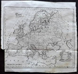
Sold2021Lochhead (Pub) 1811 Rare Map. EuropeCopper Engraved Map Published 1811 by William Lochhead, Berwick for "Modern Geography: And a Compendious General Gazetteer" Rare. Folds as issued. Paper Size: 12 x 10.5 inch (30 x 27cm) Some tone spotSee Sold Price
Sold2023[MAP] DE WIT, F. NOVA ORBIS TABULA IN LUCEM EDITAde Wit, Frederik. NOVA ORBIS TABULA, IN LUCEM EDITA. (Amsterdam: circa 1670s.) Beautiful map in exquisite full handcolouring, with elaborate corner scenes illustrating the four seasons and the Zodiac,See Sold Price
Sold2017World mapWorld map 'Nova Totius Terraum Orbis Geographica Ac Hydrographica Tabula', copper engraving map of Heinrich Hondius, dated 1630,two hemispheres the world map, surrounded by rich allegorical representaSee Sold Price
Sold2021Lochhead (Pub) 1811 Rare Map. Russia in Europe"The Southern Part of Russia in Europe with Russian and Little Tartary" Copper Engraved Map Published 1811 by William Lochhead, Berwick for "Modern Geography: And a Compendious General Gazetteer" RareSee Sold Price
Sold2022Africa.- Fries (Lorenz) [Tabula Nova Partis Africae], woodcut map, [c. 1525].Africa.- Fries (Lorenz) [Tabula Nova Partis Africae], rare Ptolemaic map of Southern Africa, a reduced version of Waldseemuller's map of 1513, from 'Claudii Ptolemaei Geographicae...', woodcut with fuSee Sold Price
Sold2023Thomson, John (Pub) 1825 Map. EuropeCopper Engraved Map Published 1825 by John Thomson, Edinburgh for "The Edinburgh School Atlas" by N. R. Hewitt. Maps Engraved by Hewitt. Original Outline Hand Colour. Rare. Paper Size: 10.5 x 8 inch (See Sold Price
Sold2022De Wit, Map of North and South America, c. 1720Property of a Private Collector, Hilton Head Island, SC Description: Frederick De Wit (circa 1629-1706), Nova Orbis Tabula In Lucem Edita, A.F. De Wit, Amsterdam: Covens and Mortier, c. 1720, publSee Sold Price
Sold2023Thomson, John (Pub) 1825 Map. Russia in EuropeCopper Engraved Map Published 1825 by John Thomson, Edinburgh for "The Edinburgh School Atlas" by N. R. Hewitt. Maps Engraved by Hewitt. Original Outline Hand Colour. Rare. Paper Size: 10.5 x 8 inch (See Sold Price
2022Blaeu, Johannes (Netherlands, 1596-1673) "The New World Map" Double Hemisphere World Map C. 1664Nova et Accuratissima Totius Terrarum Orbis Tabula Translated "The New World Map", Hand Colored w/ Elaborately Decorated Spandrels.   Sight View 16" x 21-1/2", Overall View 21" x 25-1/2"See Sold Price
Sold2017Framed Colored Engraved 17th C. World Map"Nova Totius Terrarum Sive Novi Orbis Tabula" Framed Colored Engraved 17th C. World Map by Willem Janszoon Blaeu - This interesting piece is an early world map created by Willem Janszoon Blaeu. The maSee Sold Price
Sold2019Delamarche, Felix 1829 Pair of Maps Turkey & Asia Minor"Asiae Minoris Tabula" and "Turquie d'Europe" Copper Engraved Maps Published 1829, Paris for "Atlas de La Geographie..." by Felix Delamarche. Contemporary outline hand colour. Centre fold as publishedSee Sold Price
Sold2022De Wit - Nova Orbis Tabula In Lucem Edita, MapFrederick De Wit (circa 1629-1706), Nova Orbis Tabula In Lucem Edita, A.F. De Wit, published by Covens and Mortier, Amsterdam, circa 1720, in two sheets, engraving on laid paper, double hemisphere vieSee Sold Price
Sold2018Map of Palestine - Engraving - Belgium, 16th CenturyTerrae Sanctae, quae Promissionis terra, est Syriae pars ea, quae Palaestina uocatur... edited by Gerard de Jode. Drawn after Tilemann Stella. Copperplate engraving, hand-colored. [Antwerp, 1593]. MapSee Sold Price
Sold2019Delamarche, Felix 1829 Lot 3 Maps. Europe, Roman Empire"L'Europe avant l'Invasion des Barbares" "L'Europe divisee en ses Differens etats Sous Charlemagne" and "Imperii Roman Tabula" Copper Engraved Maps Published 1829, Paris for "Atlas de La Geographie...See Sold Price
Sold2021Framed 17th C. German Engraved Map of France**First Time At Auction** Europe, German, 17th century. "Das Konigreich Franckreich" (The Kingdom of France) Nova Gallia Tabula - copper plate engraving, ca. 1630. A finely engraved map of the KingdomSee Sold Price
6 days LeftFreeman's | Hindman[MAP]. TODESCHI, Pietro. [Nova et Acurata Totius Americae Tabula auct. G.I. Blaeu] America quarta$5,000
Jun 08Trillium Antique Prints & Rare BooksCluver & De L'Isle - Map of the Eastern Hemisphere (Europe, Asia, Africa and part of Australia)$75
6 days LeftFreeman's | Hindman[MAP]. SARTINE, Antoine Plan de la Barre et du Havre de Charles-Town...1778. RARE REVOLUTIONARY WAR$1,000(1 bid)
4 days LeftJasper521752 Robert de Vaugondy Map of Middle East and Ancient Empires -- Antiquor Imperiorum Tabula, in qua$140
Jun 14DuMouchellesRigobert Bonne (French, 1727-1794) Hand Colored Engraving Ca. 18th Century, Les Etats Unis De$50(1 bid)
1 day LeftGold Coast Auctioneers17th-19th c. French Wall Art Collection Map City Sea Scapes Scenes etc.$50
4 hrs LeftTrillium Antique Prints & Rare BooksSanson - Map of Canada or New France with the Great Lakes$75(1 bid)
4 hrs LeftTrillium Antique Prints & Rare BooksSanson - Map of Florida (encompassing most of Southeast North America)$130(2 bids)


![[MAP] DE WIT, F. NOVA ORBIS TABULA IN LUCEM EDITA: de Wit, Frederik. NOVA ORBIS TABULA, IN LUCEM EDITA. (Amsterdam: circa 1670s.) Beautiful map in exquisite full handcolouring, with elaborate corner scenes illustrating the four seasons and the Zodiac,](https://p1.liveauctioneers.com/8124/310027/165853624_1_x.jpg?height=310&quality=70&version=1700184289)


![Africa.- Fries (Lorenz) [Tabula Nova Partis Africae], woodcut map, [c. 1525].: Africa.- Fries (Lorenz) [Tabula Nova Partis Africae], rare Ptolemaic map of Southern Africa, a reduced version of Waldseemuller's map of 1513, from 'Claudii Ptolemaei Geographicae...', woodcut with fu](https://p1.liveauctioneers.com/5458/260724/135800393_1_x.jpg?height=310&quality=70&version=1662479034)


![Map of Palestine - Engraving - Belgium, 16th Century: Terrae Sanctae, quae Promissionis terra, est Syriae pars ea, quae Palaestina uocatur... edited by Gerard de Jode. Drawn after Tilemann Stella. Copperplate engraving, hand-colored. [Antwerp, 1593]. Map](https://p1.liveauctioneers.com/1980/117218/60259210_1_x.jpg?height=310&quality=70&version=1520155929)


![[MAP]. TODESCHI, Pietro. [Nova et Acurata Totius Americae Tabula auct. G.I. Blaeu] America quarta (1 of 1)](https://p1.liveauctioneers.com/197/329395/177650542_1_x.jpg?height=282&quality=70&version=1715364962)


![[MAP]. ORTELIUS, Abraham. Africae Tabula Nova. 1592. (1 of 2)](https://p1.liveauctioneers.com/197/329395/177650533_1_x.jpg?height=282&quality=70&version=1715364962)

![[MAP]. SARTINE, Antoine Plan de la Barre et du Havre de Charles-Town...1778. RARE REVOLUTIONARY WAR (1 of 1)](https://p1.liveauctioneers.com/197/329395/177650540_1_x.jpg?height=282&quality=70&version=1715364962)


