Sold2019Two Maps by Johnson & Ward, consisting of "Venezuela,Two Maps by Johnson & Ward, consisting of "Venezuela, New Granada, Ecuador, Peru, Bolivia, Chile, and Guiana," 1867, hand colored, H.- 14 in., W.- 17 3/4 in.; together with "Brazil, Argentine RepublicSee Sold Price
Sold2021Two Vintage Brazil School Posters Birds & ButterfliesButterfly map Approx. size 44" X 34 1/2" Bird map 45 1/2" X 34 1/2, Published in Brazil by Ð Comp. Melhoramentos De S. Paulo. Beautiful old school posters between two wooden sticks. Butterfly map hasSee Sold Price
Sold2018Bellin: Suite of 3 Antique Brazil Maps, 1756Title/Content of Map: Carte du Bresil Prem. Partie [and] Suite du Bresil Depuis la Baye de Tous les Saints jusqu'a St. Paul [and on the same sheet] Suite du Bresil Cartographer: Bellin Place & Date: PSee Sold Price
Sold2021Findlay, Alex C1835 Antique Map. BrazilSteel Engraved Map Published C1835 by Thomas Kelly, London for "A New and Universal English Dictionary" by the Rev. James Barclay. Maps Drawn & Engraved by Alexander Findlay. Paper Size: 10.5 x 8 inchSee Sold Price
Sold2019Rare 1st issue of Hondius' Brazil map, 1629Heading: Author: Hondus, Jodocus Title: Novus Brasiliae Typus Place Published: Amsterdam Publisher:Jodocus Hondius excudit Date Published: 1629 Description: Copper-engravedSee Sold Price
Sold2021Tallis, John (Pub) 1852 Map. BrazilSteel Engraved Map with Original Outline Hand Color Published 1852-56 by John Tallis, London for "The Universal Pronouncing Dictionary" by Thomas Wright. Drawn & Engraved by John Rapkin. Centre fold aSee Sold Price
Sold2021Two Rock Crystal Spheres on Custom Metal StandsTwo Rock Crystal Spheres on Custom Metal Stands Brazil Two rock crystal quartz spheres which exhibit moderate transparency, mounted with black metal stands, each decorated with an arrow, diameter ofSee Sold Price
Sold20162 Brazil Isabella & Leopoldina MedalsTwo Brazil 1856 Isabella & Leopoldina Official Mint Visit silver medals, by Cristian Lüster, DPA #353, M #28, C #43, each measure approximately 1 1/8 inch in diameter. Total weight 1.180 troy oz. UncSee Sold Price
Sold2020U.S. AND FOREIGN PAPER CURRENCY IN ALBUMU.S. AND FOREIGN PAPER CURRENCY IN ALBUM ~ LOW DENOMINATION FOREIGN BANK NOTES FROM MEXICO AND BRAZIL, TWO U.S. TWO DOLLAR NOTES SERIES 1976 & 1953-B RED SEAL, TEN DOLLAR BILL SERIES 1928, FIVE DOLLARSee Sold Price
Sold2016John Cary: Brazil & Buenos Aires 1815Map: Brazil & Buenos Aires Publishing: John Cary Date: 1815 Size: 11 x 14 inches Original copper engraving John Cary (1754-1835) was an English cartographer who is known for his maps, globes, and hisSee Sold Price
Sold2019Brazil. North oriented to the right. With cannibals.Reserve Reduced! Title/Content of Map: Brazil. North oriented to the right. With cannibals. Date: 1598/99. Cartographer: Ruscelli Size: 11x9” Provenance: Venice. Reserve: $300.00 Jasper52 negotiatesSee Sold Price
Sold2019Brazil, Uruguay, Paraguay and Argentina.Title/Content of Map: Brazil, Uruguay, Paraguay and Argentina. Date 1863 Cartographer: By Johnson & Ward. From, Johnson’s New Illustrated Family Atlas Size: 18x14”. Provenance: New York. Not tearsSee Sold Price
Sold20191870 Mitchell map of Brazil and surrounding countriesHeading: (South America) Author: Mitchell, S. Augustus Title: Maps of Chili, Brazil, Boliva, Paraguay, Uruguay, including the Harbors of Bahia and Rio Janeiro Place Published: N.p. Publisher:N.p.See Sold Price
Sold2023SOUTH AMERICA PROTESTANT MISSIONS. Jamaica Trinidad Br. Guiana Brazil 1911 mapTitle: SOUTH AMERICA PROTESTANT MISSIONS. Jamaica Trinidad Br. Guiana Brazil 1911 map Description: South America; Inset maps of Jamaica; Trinidad; Montevideo; British Guiana; Continuation Southward onSee Sold Price
Sold2017Blaeu Map of BrazilMaritima Brasiliae Universa. Joan Blaeu (1596-1673). Engraved map with original color in part. Amsterdam: Blaeu, 1647. 21 x 24 1/2 inches sheet, 32 1/2 x 36 inches framed. This separately issued and rSee Sold Price
Sold202417th century Brazil original map. "Prefecturae Paranburae Pars Borealis" map by Blaeu. Sheet size:17th century Brazil original map. "Prefecturae Paranburae Pars Borealis" map by Blaeu. Sheet size: 18.875 x 23.375in.See Sold Price
Sold2018Hilde Weber for Osirarte Map of Brazil tableHilde Weber (1913-1994) for Osirarte Map of Brazil table Brazil, 1946 painted ceramic, cherry signed 'Osirarte Ex. Hilde' and 'Drusilla Aden S. Paolo 1946' 32 3/4"w x 21"d x 19"hSee Sold Price
Sold20221719 de Fer Map of Brazil -- Le Bresil dont les Cotes sont Divisees en Capitaineries Dresse sur lesTitle: 1719 de Fer Map of Brazil -- Le Bresil dont les Cotes sont Divisees en Capitaineries Dresse sur les Dernieres Relations des Filibustiers et Fameux Voyageurs . . . Cartographer: N de Fer Year /See Sold Price
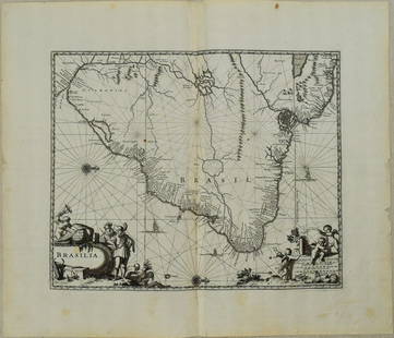
Sold20221650 Blaeu Map of Brazil -- BrasiliaTitle: 1650 Blaeu Map of Brazil -- Brasilia Cartographer: J Blaeu Year / Place: 1650, Amsterdam Map Dimension (in.): 15.2 X 19.5 in. This is a magnificent large map of most of Brazil, Guiana and UruguSee Sold Price
Sold2017Blaeu: Antique Map of Brazil, 1634Map: Novus Brasiliae Typus Cartographer: Blaeu Place & Date: Amsterdam / 1634 (circa) Size: 19 1/2" x 15" Condition: b&w; cleaned; some minor spotting; centerfold reinforced Blaeu's superb, Hondius-deSee Sold Price
Sold20231671 Ogilby Map of Brazil -- BrasiliaTitle: 1671 Ogilby Map of Brazil -- Brasilia Cartographer: J Ogilby Year / Place: 1671, London Map Dimension (in.): 11.3 X 13.8 in. This is an excellent map of the eastern part of Brazil. There is anSee Sold Price
Sold2022Antique Framed Engraved Map of Brazil"Office of Pernambuco Northern Region" (caption translation). This engraving of a map of Brazil includes an inset image showing a sugar plantation and enslaved people engaged in various tasks. In theSee Sold Price
Sold2016Map of Brazil by Pierre van der AaMap: Le Bresil, Serviant Les Nouvelles Observations De Messrs. De L'academie Royale Des Sciences, Etc. Augmenties De Nouveau Maker: Pierre van der Aa, A. Leide Size: Quarto - 9 inches high x 11.8 inchSee Sold Price
Sold2017Janssonius: Antique Map of Brazil, 1630Map: Accuratissima Brasiliae Tabula." European Depiction of Cannibalism in 1600'S Publication Date: 1630 ca. Authors: JOANNES JANSSONIUS, JANSSON, JANS Publisher: JOANNES JANSSONIUS Size: Folio – 14See Sold Price
4 days LeftJasper52Bellin Map of St. Salvador, Brazil -- Plan de la ville de St. Salvador [with] Vue de la Ville de St.$55
May 18Trillium Antique Prints & Rare BooksDe Bry - Brazil: Cannibalism: Their ceremonies for killing and eating their enemies$75
May 18Trillium Antique Prints & Rare BooksDe Bry - Brazil - How we decided to sail to Portuguese-controlled St. Vincent, and how we intended$75


![Bellin: Suite of 3 Antique Brazil Maps, 1756: Title/Content of Map: Carte du Bresil Prem. Partie [and] Suite du Bresil Depuis la Baye de Tous les Saints jusqu'a St. Paul [and on the same sheet] Suite du Bresil Cartographer: Bellin Place & Date: P](https://p1.liveauctioneers.com/5584/114563/58815206_1_x.jpg?height=310&quality=70&version=1514941693)


![Bellin Map of St. Salvador, Brazil -- Plan de la ville de St. Salvador [with] Vue de la Ville de St. (1 of 1)](https://p1.liveauctioneers.com/5584/328338/176911634_1_x.jpg?height=282&quality=70&version=1715113718)


