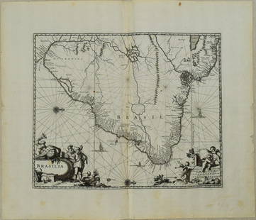
Sold20231671 Ogilby Map of Brazil -- BrasiliaTitle: 1671 Ogilby Map of Brazil -- Brasilia Cartographer: J Ogilby Year / Place: 1671, London Map Dimension (in.): 11.3 X 13.8 in. This is an excellent map of the eastern part of Brazil. There is anSee Sold Price
Sold20231671 Ogilby Map of Panama and Northern South America -- Terra Firma et Novum Regnum Granatense etDescriptionTitle: 1671 Ogilby Map of Panama and Northern South America -- Terra Firma et Novum Regnum Granatense et PopayanCartographer: J OgilbyYear / Place: 1671, LondonMap Dimension (in.): 11.3 X 1See Sold Price
Sold20221650 Blaeu Map of Brazil -- BrasiliaTitle: 1650 Blaeu Map of Brazil -- Brasilia Cartographer: J Blaeu Year / Place: 1650, Amsterdam Map Dimension (in.): 15.2 X 19.5 in. This is a magnificent large map of most of Brazil, Guiana and UruguSee Sold Price
Sold20201671 Montanus/Ogilby Map of Chile -- ChiliTitle/Content of Map: 1671 Montanus/Ogilby Map of Chile -- Chili Cartographer: Montanus/Ogilby Year/Place: 1671, London Size: 11.2 X 14.2 in. This is a very attractive map covering the coastal regionSee Sold Price
Sold2024Churchill & Nieuhof 1744 Folio Map. Brasilia BrazilFolio Copper Engraved Map Published 1704-47 [1744] London for "A Collection of Voyages and Travels..." By Awnsham & John Churchill. The work based mostly on the Voyages and Travels into Brasil and theSee Sold Price
Sold2017Nova Mexico folding map from American 1671 by OgilbyOgilby, John, 1600-1676, Montanus, Arnoldus, 1625?-1683, Nova Mexico from Novissima et Accuratissima Totius Americae Descriptio.11 x 21.25 inches, America: Being The Latest, And Most accurate DescriptSee Sold Price
Sold2018Montanus / Ogilby Novi BelgiMontanus, Petrus (1595-1638) & Ogilby, John (1600-1676). Nova Belgii Quod Nunc Novi Jork Vocatur... Engraved map with original color. J. Ogilby, 1671. 11 ½" x 14 ½" sheet. Centering on Long IslaSee Sold Price
Sold2017Montanus / Ogilby: Antique Map of Central America, 1671Map: Yucatan . . . et Guatimala Cartographer: Montanus / Ogilby Place & Date: Amsterdam / 1671 Size: 14 1/4" x 11 1/4" Condition: b&w; overall age toning and some spotting The detailed map of southeasSee Sold Price
Sold2019Montanus / Ogilby: Antique Map of Central America, 1671The detailed map of southeastern Mexico and Central America from Ogilby's English edition of Montanus' influential history of America. The map encompasses the Mexican heartland, the Yucatan peninsula,See Sold Price
Sold2023Ogilby / Montanus Map of the AmericasOGILBY, John (1600-1676) / MONTANUS, Arnoldus (c. 1625–1683). Insulae Americanae in Oceano Septentrionali cum Terris adiacentibus. Engraved map. London, 1671 (Second state). 16" x 20 1/2" sheet, 33"See Sold Price
Sold2024John Ogilby 1671 Antique "Nova Virginiae Tabula" Pencil Signed Hand Colored Virginia MapAntique 1671 hand-colored and pencil-signed "Nova Virginiae Tabula" map of Virginia and Chesapeake region. In good overall condition, with age-appropriate wear. Approx. image size 11 1/4" x 14". ApproSee Sold Price
Sold2021MAP, Itamaraca, Brazil, MontanusItamaraca, Brazil. Arnoldus Montanus, I. Tamaraca, from De Nieuwe en Onbekende Weereld, 1671 (circa). Black & White. This fine view shows the Dutch Fort Oranje on the island of Itamaraca, off the nortSee Sold Price
Sold2020Map, John OgilbyJohn Ogilby (British, 1600-1676), "Nova Hispania Nova Galicia Guatimala (with part of Florida and Cuba)," 1671, hand-colored engraving, sight (image): 14"h x 11.5"w, overall (with mat/unframed): 17.5"See Sold Price
Sold2023Atq JOHAN HOMANN Peru & Brazil Cartographic MapAntique circa first half of 18th century cartographic map of Peru and Brazil. Maker Homanianos Heredes (Johann Homann). Reads: Tabula America Specilialis Geographica Regni Peru, Brasilia Terra Firma.See Sold Price
Sold2022Nova Hispania Nova Galicia Guatimala. 1671.[Map/South America] Ogilby, John; Montanus Arnoldus. Nova Hispania Nova Galicia Guatimala. 1671. Hand colored copperplate engraved map. Framed: This map, based on the cartography of Hessel Gerritsz, iSee Sold Price
Sold20201671 Yucatan Conventus Iuridici Hispaniæ Novæ ParsBy John Ogilby, London, ca. 1671 28.5 cm x 36 cm Excellent clear print. Paper is darkened at the edges, far from the map margins. Focus is on Central America, extending down from Tampico on the Bay ofSee Sold Price
Sold2023An important historical map by Montanus and Ogilby depicting New York, New England, and Virginia,An important historical map by Montanus and Ogilby depicting New York, New England, and Virginia, published in 1671. This map from a Jansson-Visscher map of the Northeast, extending from the St. LaureSee Sold Price
Sold2019MAP - Guyana, Suriname, French Guiana. MontanusGuyana, Suriname, French Guiana. Montanus/Ogilby, Guiana sive Amazonum Regio, 1671 (circa). Hand Color. This decorative map covers the region from the Isla Margarita in the northwest to the coast of nSee Sold Price
Sold2024Map Of The Kingdom Of New Granada And Popayan By John OgilbyLikely removed from Ogilby's Atlas of America Published 1671, Site 11.5" x 14"See Sold Price
Sold2023MAP, Mexico, MontanusAcapulco, Mexico. Montanus/Ogilby, Portus Acapulco, from America, 1671 (circa). Black & White. This attractive copper engraved view of Acapulco and its bay is a nice rendering of the town, with fortifSee Sold Price
Sold2021Montanus 1671 Map of Mexico & Central AmericaDESCRIPTION: Map by cartographer Montanus extending to Costa Rica, based off cartographer Gerritsz's work. Title cartouche is bright and colorful reading "NOVA HISPANIA NOVA GALICIA GUATIMALA" and depSee Sold Price
Sold2019Map - Brasilia TabulaMap, Brasilia Tabula. [Art: 15 x 18 inches; Frame: 22 x 26 inches]. Age toning.See Sold Price
Sold2021Tallis, John (Pub) 1852 Map. BrazilSteel Engraved Map with Original Outline Hand Color Published 1852-56 by John Tallis, London for "The Universal Pronouncing Dictionary" by Thomas Wright. Drawn & Engraved by John Rapkin. Centre fold aSee Sold Price
Sold2021Findlay, Alex C1835 Antique Map. BrazilSteel Engraved Map Published C1835 by Thomas Kelly, London for "A New and Universal English Dictionary" by the Rev. James Barclay. Maps Drawn & Engraved by Alexander Findlay. Paper Size: 10.5 x 8 inchSee Sold Price
1 day LeftJasper521775-1780 Uruguay, Northern Argentina, Southern Brazil, and Rio de Janeiro. By Bonne & Raynal$30
May 14Fleischer's Auctions1755 Map Partie de l'Amerique Septentrionale, qui comprend Le Cours de L'Ohio...$200(3 bids)
5 days LeftCrescent City Auction GalleryWilliam H. Williams (1817-1886), New Orleans "Map of the Sixth District and Carrollton," 1871, H.-$650
May 18Nadeau's Auction GalleryPair of Broyhill Brasilia Mid-Century Modern Two Part Cabinets$400(1 bid)
6 days LeftSchilb Antiquarian Rare Books1977 JRR Tolkien 1st ed 1st Printing Silmarillion Lord of the Rings + MAP + DJ$200(5 bids)
3 days LeftHunt and Peck Estate Services, Inc.Jacques Nicolas Bellin Map Of Western Part Of New France Or Canada$220(2 bids)
May 15University ArchivesFeb. 1777 Issue of The Gentleman's Magazine with Superb Map of Philadelphia$140(1 bid)
6 days LeftSchilb Antiquarian Rare Books1883 FLORIDA for Tourists & Settlers Illustrated Fort Barrancas MAP Fine BINDING$90(5 bids)
6 days LeftSchilb Antiquarian Rare Books1859 AFRICA VOYAGES Barth Timbuktu Tripoli SLAVES Illustrated Slavery MAP African$62(4 bids)
3 days LeftHunt and Peck Estate Services, Inc.1794 Laurie & Whittle after Thomas Jefferys Map Of The United States Of America$360(2 bids)
May 18Avra Art Auctions YOSHIYA TAKAOKA (1909-1978, Japan, Brazil) Sao Paulo Artist, Label Verso$20(1 bid)
3 days LeftHunt and Peck Estate Services, Inc.Abraham Ortelius Map Middle East "Turcici Imperii Descriptio"$240(1 bid)


![Churchill & Nieuhof 1744 Folio Map. Brasilia Brazil: Folio Copper Engraved Map Published 1704-47 [1744] London for "A Collection of Voyages and Travels..." By Awnsham & John Churchill. The work based mostly on the Voyages and Travels into Brasil and the](https://p1.liveauctioneers.com/3952/320085/171971821_1_x.jpg?height=310&quality=70&version=1708266709)


![Nova Hispania Nova Galicia Guatimala. 1671.: [Map/South America] Ogilby, John; Montanus Arnoldus. Nova Hispania Nova Galicia Guatimala. 1671. Hand colored copperplate engraved map. Framed: This map, based on the cartography of Hessel Gerritsz, i](https://p1.liveauctioneers.com/179/268856/140616119_1_x.jpg?height=310&quality=70&version=1668545725)


![Map - Brasilia Tabula: Map, Brasilia Tabula. [Art: 15 x 18 inches; Frame: 22 x 26 inches]. Age toning.](https://p1.liveauctioneers.com/1221/144060/73442991_1_x.jpg?height=310&quality=70&version=1562691258)


