Sold20231866 Schönberg's Early Map of Texas Historic Vintage Inspired Map1866 Schönberg's Early Map of Texas Historic Vintage Inspired Map As settlers spread west, Schönberg's map of Texas shows the growing state of Texas and the contemporary counties as ofSee Sold Price
Sold20221866 Schönberg's Early Map of Texas Historic Vintage Inspired Map1866 Schönberg's Early Map of Texas Historic Vintage Inspired Map As settlers spread west, Schönberg's map of Texas shows the growing state of Texas and the contemporary counties as ofSee Sold Price
Sold2021Early U.S. map shows Texas, Upper Calif. – 1839Title: Early U.S. map shows Texas, Upper Calif. – 1839 Description: Vintage and interesting geography map showing Texas and Upper California at a time when they made up the entire southwestern UniteSee Sold Price
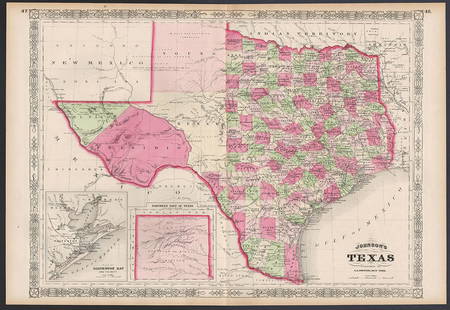
Sold2023Excellent example of Johnson’s Texas, 1866Authentic and impressive vintage map of Texas. One of the more collectible maps to be produced in the mid-19th century. A highly desirable map that details the state in full. Shows the elevated TableSee Sold Price
Sold2022Vintage Maps of Texas CountiesBound vintage book containing maps of Texas counties, featuring maps based off early twentieth century cartography 1.5"h x 17"w x 14"d We happily provide seamless shipping services on everything weSee Sold Price
Sold2022Exceptional map of Johnson's Texas, 1866Authentic and impressive vintage map of Texas. A highly desirable map that details the state in full. Shows the elevated Table Lands, the U. S. Mail Route, the Staked Plain (El Llando Estadado), numerSee Sold Price
Sold2022Vintage County Maps of Texas Topography Maps TexasThese are vintage maps that were first made in 1915 and 1921. These maps are a great glance into the early official mapping of the Americas. The two maps in this lot are of Texas. (1) Topography map oSee Sold Price
Sold2021San Antonio Conservation Society 1926 MapVintage 1926 San Antonio Conservation Society historic guide map of San Antonio de Bexar, drawn by Emily Edwards, portrays San Antonio from 1682-1721, unframed 39 x 28"; Provenance: A Schertz, TX EsSee Sold Price
Sold2022San Antonio Conservation Society 1926 MapVintage 1926 San Antonio Conservation Society historic guide map of San Antonio de Bexar, drawn by Emily Edwards, portrays San Antonio from 1685-1721, framed, dated 1926 41"h x 30"w Provenance: A SSee Sold Price
Sold2021Fascinating and scarce 1876 map of Montana TerritoryTitle: Fascinating and scarce 1876 map of Montana Territory Description: "Historic vintage map of the Montana Territory published the year of Custer’s massacre near the Little Big Horn River. This mSee Sold Price
Sold2021Important Texas Historical MemorabiliaCollection of Important Texas Historical Memorabilia including a 1936 Centennial state flag, two early maps of Texas - the first a "Map of Texas as a Republic" by T. G. Bradford, engraved by G. W. BoySee Sold Price
Sold2021Two Early Maps of the Texas RepublicTwo Early Maps of the Texas Republic each engraved with hand-coloring, the first by T. G. Bradford, engraved by G. W. Boynton, published Boston, 1838; the second by C. S. Williams, from A New UniversaSee Sold Price
Sold2021Set 8 of School Charts - Texas History and ResourcesSet 8 of Vintage School Charts Maps - Texas History and Resources36 in tall x 45 x 1 - Denoyer - Geppert of Chicago / J. L Clark & Lewis W. NewtonSee Sold Price
Sold2021c 1730 Seutter Map: Novi Belgii, in America ...Historic Maps c. 1730 Historic Rare Earlier State of Seutter's Important American Northeast Map & New York City Restitutio View c. 1730 Hand-Colored Copper-Engraved Map titled, "Recens Edita totius NoSee Sold Price
Sold20211721 Map of America With California as an IslandHistoric Maps 1721 Hand-Colored "A New Map of America from the Latest Observations" with "California" Shown as an Island 1721 Hand-Colored Engraved Western Hemisphere Map titled, "A New Map of AmericaSee Sold Price
Sold2024E.O. Goldbeck (1892-1986), Texas Oil Field PhotoVintage pictorial map of oilfields of Burkburnett, Texas, dated April 15th, 1919, marked #2, photographed by Charles Steele, framed sight: 8.5 x 60.5 in., frame: 13.5 x 65.5 in. Provenance: PropertySee Sold Price
Sold2023Early Leather Bound BooksEarly leather bound books including 1848 Lorenzo Dow's Journal (4th ed), 1853 Zadock Thompson's History of Vermont (with hand-colored fold-out map and appendix)- covers loose, 1866 Palmer History of LSee Sold Price
Sold2022Petrus Kaerius and Abraham Ortelius, Two Vintage MapsPETRUS KAERIUS and ABRAHAM ORTELIUS (Flemish, 1571-1646), and (Belgian, 1527-1598), Orbis Terrarum Typus De Integro Multis In Locis Emendatus auctore Petro Kaerio anno 1607, and Indiae Orientalis InsuSee Sold Price
Sold20241850 map of Holland and Belgium – Mitchell/CowperthwaitAn authentic vintage map of what is known as the Low Countries—Holland and Belgium. With an 1850 copyright date and found in an 1853 edition of Mitchell’s New Universal Atlas. A very cleanSee Sold Price
Sold2022(REPUBLIC OF TEXAS.) James Hamilton Young. A New Map of Texas, with the Contiguous American &(REPUBLIC OF TEXAS.) James Hamilton Young. A New Map of Texas, with the Contiguous American & Mexican States. Hand-colored engraved map of Texas with inset text panels relating information on its riveSee Sold Price
Sold2023MITCHELL'S NEW MAP of TEXAS, OREGON & CALIFORNIA1846 Philadelphia, S. Augustus Mitchell. hardcover leather bound. 5 1/4 x 3 1/4 inches. Map unfolded 22 x 20 1/2 inches and presented in a custom frame 23 1/2 x 22 inches (overall)See Sold Price
Sold2022MITCHELL, S. AUGUSTUS. A New Map of Texas, Oregon and California.MITCHELL, S. AUGUSTUS. A New Map of Texas, Oregon and California. Engraved pocket map of the American territories west of the Mississippi River. 22¾x21 inches overall, ample margins; strong origiSee Sold Price
Sold2018Young New Map of TexasA New Map of Texas with the contiguous American and Mexican States. James Hamilton Young. Engraved map with original hand color. Philadelphia: S. Augustus Mitchell, 1839. 13 x 15 1/2 inches visible, 1See Sold Price
Sold2021A New Map of Texas, Oregon and California"A New Map of Texas, Oregon and California with the Regions Adjoining" by S. Augustus Mitchell, engraving with hand-coloring, 1st edition, published Philadelphia, 1846; framed together with original bSee Sold Price
2 days LeftTrillium Antique Prints & Rare BooksPtolemy & Magini, pub. 1620 - Map of the World with Six Windheads$130(4 bids)
2 days LeftTrillium Antique Prints & Rare BooksPtolemy & Magini, pub. 1620 - Double Hemisphere Map of the World$400(5 bids)
11 hrs LeftLeland LittleAmbrosius Macrobius's Commentary on Cicero's The Dream of Scipio , with Rare Woodcut Map$325(4 bids)
May 12Schilb Antiquarian Rare Books1977 JRR Tolkien 1st ed 1st Printing Silmarillion Lord of the Rings + MAP + DJ$200(5 bids)
11 hrs LeftLeland LittleElsevier Edition of Quintus Curtius Rufus's Illustrated Biography of Alexander the Great$50


![[Ambrotype] Texas Confederate Soldier (1 of 1)](https://p1.liveauctioneers.com/7226/322253/173251509_1_x.jpg?height=282&quality=70&version=1710004847)


![[Maps] American Atlas, Folio (1 of 14)](https://p1.liveauctioneers.com/3532/326332/175680379_1_x.jpg?height=282&quality=70&version=1713151485)


![Photographer & Camera [CDV] (1 of 1)](https://p1.liveauctioneers.com/7226/322253/173251711_1_x.jpg?height=282&quality=70&version=1710004847)

