Sold2022Scandinavia.- Moll (Herman) A New Map of Denmark and Sweden according to ye newest and most exactScandinavia.- Moll (Herman) A New Map of Denmark and Sweden according to ye newest and most exact observations..., large detailed map with inset map of the Northern part of Norway, Lapland and GreenlaSee Sold Price
Sold2022(AMERICAS.) Herman Moll. A Map of America According to ye Newest and Most Exact Observations.(AMERICAS.) Herman Moll. A Map of America According to ye Newest and Most Exact Observations. Engraved map of North and South America showing California as an island. 11½x7¾ inches sheet sizSee Sold Price
Sold2017Herman Moll A New Map of Great Britain 1717. TitlHerman Moll A New Map of Great Britain 1717. Title: 'A New Map of Great Britain According to the Newest and Most Exact Observations'. A large and very intricate map of the British isles with colouredSee Sold Price
Sold2022MAP, China, Korea & Japan, MollChina, Korea & Japan. Herman Moll, China According to the Newest and Most Exact Observations, 1720 (circa). Hand Color. Nice copper engraved map in Moll's typical style presents the Korean peninsula,See Sold Price
Sold2019Moll map with California an Island. 1708Heading: Author: Moll, Herman Title: A Map of America. According to ye Newest and Most Exact Observations Place Published: London Publisher: Date Published: 1708 Description:See Sold Price
Sold2017Moll: Antique Map of Arabia, 1712Title: Arabia, According to the Newest and most Exact Observations. 1712 Moll map of Arabia with Hajj route from Basra Map maker: Herman Moll Place and Year: London, c. 1712 Dimensions: 17.5 x 25.5 cmSee Sold Price
Sold2017A New and Exact Map of France Dividid HERMAN MOLLDetails: MOLL, Herman (fl. 1678-1732). A New and Exact Map of France Dividid [sic] into all its provinces and acquisitions, according to the newest observations, and that accurate survey made by theSee Sold Price
Sold2022MOLL, HERMAN. A New Map of the North Parts of America claimed by France under ye Names of Louisiana,MOLL, HERMAN. A New Map of the North Parts of America claimed by France under ye Names of Louisiana, Mississipi, Canada and New France with ye Adjoyning Territories of England and Spain. Large engraveSee Sold Price
Sold2022BEAVER MAP, HERMAN MOLL (DUTCH/BRITISH, 1654-1732)A New and Exact Map of the Dominions of the King of Great Britain on ye Continent of North America containing Newfoundland, New Scotland, New England, New York, New Jersey, Pensilvania, Maryland, VirgSee Sold Price
Sold2022Herman Moll's New Map of the World - California as an Island!, Ca. 1725Herman Moll's New Map of the World - California as an Island!, Ca. 1725 1p, measuring 13.625" x 8.5", n.p., ca. 1725. A hand-colored map entitled "A New Map of the World according to the New ObservatiSee Sold Price
Sold2017FRAMED WORLD MAP BY HERMAN MOLL, 1719'A New & Correct Map of the Whole World, by Herman Moll, Geographer, 1719.' Hand tinted and framed. Frame size: 73 x 124 cm (28 3/4 x 48 3/4 in.)See Sold Price
Sold2022MOLL, HERMAN. [The World Described].MOLL, HERMAN. [The World Described]. 18 engraved multiple-sheet folding maps with original outline hand-color (i.e., incomplete; no beaver map, no codfish map). Tall folio, 25x12 inches, period calf bSee Sold Price
Sold2022World.- Speed (John) A New and Accurat Map of the World Drawne according to ye truest DescriptionsWorld.- Speed (John) A New and Accurat Map of the World Drawne according to ye truest Descriptions latest Discoveries & best observations yt have beene made by English or Strangers, double-hemisphereSee Sold Price
Sold2019Herman Moll 1654-1732), "A New And Correct Map of theHerman Moll 1654-1732), "A New And Correct Map of the World," 1710, hand colored, H. - 22 in., W. - 38 in.See Sold Price
Sold2016JOHN SPEED (BRITISH, 1552-1629) MAP OF THE WORLDJOHN SPEED (BRITISH, 1552-1629) MAP OF THE WORLD, (UPDATED 6/14/16) hand-colored engraving on laid paper, titled "A New and Accurat Map of the World Drawne according to ye truest Descriptions latest DSee Sold Price
Sold2017Moll - Correct Map of the Whole World, 1719Herman Moll (1654?-1732), cartographer and publisher A New & Correct Map of the Whole World Shewing y.e Situation of its Principal Parts. Viz the Oceans, Kingdoms, Rivers, Capes, Ports, Mountains, WooSee Sold Price
Sold2024Map of the North Parts of America Claimed by France by Herman Moll (London, 1720)Map of the North Parts of America Claimed by France by Herman Moll (London, 1720) "A New Map of the North Parts of America claimed by France under ye Names of Louisiana, Mississippi, Canada, and New FSee Sold Price
Sold2022(MEXICO.) Henry Schenk Tanner. A Map of the United States of Mexico,(MEXICO.) Henry Schenk Tanner. A Map of the United States of Mexico, As Organized and Defined by the Several Acts of Congress of that Republic. Large hand-colored lithographed map of southwestern NortSee Sold Price
Sold2022DES BARRES, JOSEPH FREDERICK WALLET The North East Shore of the Gulph of Mexico. London: circa 1780.DES BARRES, JOSEPH FREDERICK WALLET The North East Shore of the Gulph of Mexico. London: circa 1780. A very large hand-colored engraved map on four joined sheets. Overall 30 x 84 inches (76 x 214 cm).See Sold Price
Sold2019Asia.- Clouet (Jean Baptiste Louis) Carte D'AsieAsia.- Clouet (Jean Baptiste Louis) Carte D'Asie Divisée en ses Principaux Etats, large wall map of Asia, with two title cartouches in French and Spanish, decorative borders containing twenty vigSee Sold Price
Sold2021Ancient Japanese Jomon Pottery Jar TL TestedEast Asia, Japan, Middle to Late Jomon period, ca. 2500 to 1500 BCE. A large hand-built pottery vessel of a sprouting form with a flat base and flared rim. The cylindrical exterior walls are texturedSee Sold Price
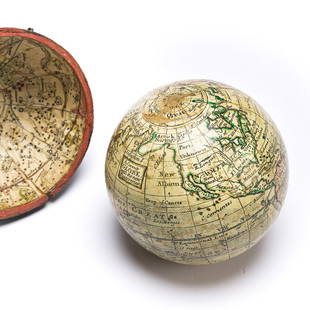
Sold2023(GLOBES.) Style of Herman Moll. A Correct Globe with the New Discoveries.(GLOBES.) Style of Herman Moll. A Correct Globe with the New Discoveries. 2¾-inch miniature terrestrial pocket globe comprised of 12 hand-colored engraved gores and 2 polar calottes on a plasterSee Sold Price
Sold2018Bleau Map of AsiaBLAEU, Willem Janszoon (1571-1638). Asia Noviter Delineata…Engraved map with original hand color. Amsterdam, c. 1618-1650. 20 x 24 inches sheet, 25 1/8 x 21 3/8 inches framed This is one of the mostSee Sold Price
Sold2021Arrowsmith's large map of America 1804Heading: Author: Arrowsmith, Aaron Title: Map of America Place Published: London Publisher:A. Arrowsmith Date Published: 1804 Description: Engraved map, hand-colored, with uncolSee Sold Price
1 day LeftHunt and Peck Estate Services, Inc.The Scots Settlement in America called New Caledonia$100
Featured11 hrs LeftJasper52Barbuda Island. West Indies Caribbean. ADMIRALTY sea chart 1850 (1966) old map$120
Featured11 hrs LeftJasper52The Bahamas, Cuba & Bermuda "or Summer Islands". THOMSON 1817 old antique map$180
3 days LeftBidhausRon Campbell Magical Mystery Tour Original Hand Drawn Beatles Record Album Art$70(2 bids)
1 day LeftMynt AuctionsIker Casillas Hand Signed Autographed Jumbo 11x14 Photo Real Madrid GA$10(1 bid)
1 day LeftMynt AuctionsMorgan Spurlock "Yippee!! Obesity!" Signed McDonalds Large Fry PSA/DNA #V22465$10


![A New and Exact Map of France Dividid HERMAN MOLL: Details: MOLL, Herman (fl. 1678-1732). A New and Exact Map of France Dividid [sic] into all its provinces and acquisitions, according to the newest observations, and that accurate survey made by the](https://p1.liveauctioneers.com/5671/103625/53044992_1_x.jpg?height=310&quality=70&version=1494009518)


![MOLL, HERMAN. [The World Described].: MOLL, HERMAN. [The World Described]. 18 engraved multiple-sheet folding maps with original outline hand-color (i.e., incomplete; no beaver map, no codfish map). Tall folio, 25x12 inches, period calf b](https://p1.liveauctioneers.com/199/251723/130782476_1_x.jpg?height=310&quality=70&version=1655133895)