Sold2017Moll - Correct Map of the Whole World, 1719Herman Moll (1654?-1732), cartographer and publisher A New & Correct Map of the Whole World Shewing y.e Situation of its Principal Parts. Viz the Oceans, Kingdoms, Rivers, Capes, Ports, Mountains, WooSee Sold Price
Sold2017FRAMED WORLD MAP BY HERMAN MOLL, 1719'A New & Correct Map of the Whole World, by Herman Moll, Geographer, 1719.' Hand tinted and framed. Frame size: 73 x 124 cm (28 3/4 x 48 3/4 in.)See Sold Price
Sold20231732 H Moll New Map of the Whole World & Tradewinds1732 H Moll New Map of the Whole World with the Tradewinds. Framed, image 8 1/2 x 11 in acid free matt. Hand coloring in map.See Sold Price
Sold2018Framed Map of the World, Dated 1719Framed map of the whole world, dated 1719. [31 x 50 inches]. Moderate condition; tape shows through.See Sold Price
Sold2023Eglomise World Map Coffee Table20th century reverse-painted glass coffee table with reproduction of the 1730 original by Herman Moll, titled "A New and Correct Map of the World Laid Down According to the Newest Discoveries and FromSee Sold Price
Sold2019Herman Moll 1654-1732), "A New And Correct Map of theHerman Moll 1654-1732), "A New And Correct Map of the World," 1710, hand colored, H. - 22 in., W. - 38 in.See Sold Price
Sold2018Moll: Antique Map of World Trade Winds, 1746Title/Content of Map: World Trade Winds by Moll Date Printed: 1746 Cartographer: Thomas Salmom & Herman Moll Material/Medium: Paper Size: 20 1/2" x 9 1/4" Copperplate engraved. Published in London inSee Sold Price
Sold20211747 Map of the Whole World Known to AncientsA Map of the Whole World as far as it was Known to the Antients, published by Paul Knapton, London 1747. Fine condition. The map measures 9.5 x 6" with large margins. Fine condition. Reserve: $50.00 SSee Sold Price
Sold2023Cartography14. Cartography.A New and Correct Map of the World According to the Latest Discoveries. Double-page engraved map. 17 x 26-1/2 inches, outlined in color; a few stains, hole at upper right corner, generSee Sold Price
Sold20223 PC. FRAMED WORLD MAPS3 PC. FRAMED WORLD MAPS: Comprising; 1- A reduced scale world map based on Mercator's map of 1569. 1- 18th-century hand-colored, A New Map of the Whole World with the Tradewinds According To The LatesSee Sold Price
Sold2022Herman Moll's New Map of the World - California as an Island!, Ca. 1725Herman Moll's New Map of the World - California as an Island!, Ca. 1725 1p, measuring 13.625" x 8.5", n.p., ca. 1725. A hand-colored map entitled "A New Map of the World according to the New ObservatiSee Sold Price
Sold2018HERMANN MOLL (BRITISH, 1654-1732) MAP OF THE WORLDHERMANN MOLL (BRITISH, 1654-1732) MAP OF THE WORLD, engraving on laid paper, double hemispheric form with North Pole inset, showing California as an island, titled "A NEW MAP OF THE WORLD according toSee Sold Price
2022Allard, Carel (Netherlands, 1648-1709) World Map C.1696Flat Globe Commonly Called The Whole World Sight View 20-1/2" x 23-3/4", Overall 21-1/4" x 25" "Planispharium Terrestre, Sive Terrarum Orbis, Planispearice Constructi Representatio QuintupleSee Sold Price
Sold2019McCormick's Map of the WorldReserve Reduced! Title/Content of Map: McCormick's Map of the World Date: 1930 © Material/Medium: McCormick & Co., Inc. Size: 15.5Height - 17.5Width Standard of Quality the whole world over. BSee Sold Price
Sold2023Large 1719 Dutch bible published by Pieter Keur, Amsterdam. Illustrated with numerous engravings ofLarge 1719 Dutch bible published by Pieter Keur, Amsterdam. Illustrated with numerous engravings of biblical scenes and a double page world map. Tooled full leather binding with heavy brass mounts andSee Sold Price
Sold2022MAP, China, Korea & Japan, MollChina, Korea & Japan. Herman Moll, China According to the Newest and Most Exact Observations, 1720 (circa). Hand Color. Nice copper engraved map in Moll's typical style presents the Korean peninsula,See Sold Price
Sold2023MAP, Africa, MollNorthern Africa. Herman Moll, Patriarchatus Alexandrini. Geographica Nova Descriptio, from The Works of the Learned Joseph Bingham..., 1726 (published). Black & White. Engraved in Herman Moll's unmistSee Sold Price
Sold2022MAP, Middle East, MollMiddle East & Cyprus. Herman Moll, The North Part of Turky in Asia Containing Asia Minor, Armenia, Syria, Diarbeck, Irac-Arabick &c., from Atlas Geographus, 1712 (circa). Black & White. This uncommonSee Sold Price
Sold2020World. ‘ the Mother Earth map’Title: World. ‘ the Mother Earth map’ Date/Period: 1732/1736 Materials: Copperplate engraved Dimensions: 13 1/2 x 9” By. H. Moll. From. Atlas minor. Published, London Reserve: $800.00 Shipping:See Sold Price
Sold2018Kitchin - 10 Engraved Maps from 'A General Atlas'Thomas Kitchin (or Thomas Kitchen) (1719-1784), 10 Engraved Maps from A General Atlas, Describing the Whole Universe: Being a Complete and New Collection of The Most Approved Maps Extant; Corrected wiSee Sold Price
Sold20211716 Nova Anglia Septentrionali Americae implanataBy: Johann Baptiste HomannDate: 1719 (published) AmsterdamDimensions: 19 x 22.5 inches (48 x 57 cm)An intriguing map of the northeastern portion of the United States at a time when several European naSee Sold Price
Sold2022MOLL, HERMAN. [The World Described].MOLL, HERMAN. [The World Described]. 18 engraved multiple-sheet folding maps with original outline hand-color (i.e., incomplete; no beaver map, no codfish map). Tall folio, 25x12 inches, period calf bSee Sold Price
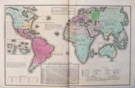
Sold2017Smith: Antique Map of the World, 1835Map: 1835 Smith World Map -- A Chart Exhibiting the Actual and Comparative Size of each Country, Nation, or Kingdom; its Population as a Whole and to a Square Mile. Also the Different States of SocietSee Sold Price
Sold20211835 Smith World Map -- A Chart Exhibiting the ActualTitle: 1835 Smith World Map -- A Chart Exhibiting the Actual and Comparative Size of each Country, Nation, or Kingdom; its Population as a Whole and to a Square Mile. Also the Different States of SociSee Sold Price
May 12Schilb Antiquarian Rare Books1937 John Steinbeck 1st ed Of Mice and Men California Great Depression Classic$120(7 bids)
1 day LeftTrillium Antique Prints & Rare BooksPtolemy & Magini, pub. 1620 - Map of the World$50(1 bid)
May 17Royal Treasures Warehouse LLC1530s Old Map of the World as seen from the North & South Poles$100
May 16Potter & Potter AuctionsLANGENECKERT. It’s A Dog’s World. 1968. St. Louis: Ralston ...$100
1 day LeftTrillium Antique Prints & Rare BooksCarey, pub. 1814 - Map of the East Indies with India, China, & New Holland (Australia)$50(1 bid)


![Framed Map of the World, Dated 1719: Framed map of the whole world, dated 1719. [31 x 50 inches]. Moderate condition; tape shows through.](https://p1.liveauctioneers.com/1221/128419/65884062_1_x.jpg?height=310&quality=70&version=1539717036)


![MOLL, HERMAN. [The World Described].: MOLL, HERMAN. [The World Described]. 18 engraved multiple-sheet folding maps with original outline hand-color (i.e., incomplete; no beaver map, no codfish map). Tall folio, 25x12 inches, period calf b](https://p1.liveauctioneers.com/199/251723/130782476_1_x.jpg?height=310&quality=70&version=1655133895)