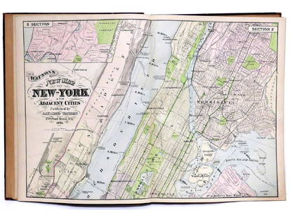
Sold2023"Atlas Of The Hudson River Valley From New York City To Troy", by F.W. Beers, hand colored maps in"Atlas Of The Hudson River Valley From New York City To Troy", by F.W. Beers, hand colored maps in large folio, published by Watson & Co. New York 1891. Each map page with canvas backing so most map pSee Sold Price
Sold20211891 Large F.W. Beers Atlas of the Hudson River ValleyAtlas of the Hudson River Valley from New York City to Troy, by F.W. Beers, published by Watson and Co, New York, 1891. Oversize hardcover folio format contains incredible map pages with much typograpSee Sold Price
Sold2022Rare Rev. War map of Hudson River campaign, pre-Vermont, 1832Rare Revolutionary War battle map of the important Hudson River corridor showing northern New England and Quebec. This map is from the rare atlas from John Marshall’s “Life of Washington” publisSee Sold Price
Sold2022Early HUDSON RIVER MAP, softcover, by BRYANT UNION PUBLISHING CO. NEW YORK CITY. Measures approx.Early HUDSON RIVER MAP, softcover, by BRYANT UNION PUBLISHING CO. NEW YORK CITY. Measures approx. 104" long, on back side is prominent places & advertising. Nice overall condition for its fragility. ISee Sold Price
Sold202219th c Hudson River panoramic map with poem on back, in treen barrel form, intact, has to be removed19th c Hudson River panoramic map with poem on back, in treen barrel form, intact, has to be removed and put back carefully, from local Hudson Valley estate. Small tears on map, overall for age & howSee Sold Price
Sold20231891 F.W. BEERS ATLAS OF THE HUDSON RIVER NYC TO TROY 21" X 16 1/2" BAD COVER AND BINDING BUT THE1891 F.W. BEERS ATLAS OF THE HUDSON RIVER NYC TO TROY 21" X 16 1/2" BAD COVER AND BINDING BUT THE INTERIOR IS GOODSee Sold Price
Sold2017ATLAS OF THE HUDSON RIVER VALLEY FROM NEW YORK CITY TOATLAS OF THE HUDSON RIVER VALLEY FROM NEW YORK CITY TO TROY, F.W. BEERS, WATSON & CO., 1891 (COMPLETE) "PRESENTED TO THE HUDSON RIVER LODGE NO.607, COMPLIMENTS OF BROS. G.H. & G.E. JACOBS, NEWBURGH NYSee Sold Price
Sold20211891 BEERS RARE ATLAS OF THE HUDSON RIVER VALLEY ,1891 BEERS RARE ATLAS OF THE HUDSON RIVER VALLEY , COMPLETE, FROM ESTATE IN STANFORDVILLE, N.Y. VERY HARD ATLAS TO FIND…..See Sold Price
Sold2016Map, Hudson River, Rev. War, Sauthier, 1776At the top of the map is written: "A Topographical Map of Hudsons River, with the Channels Depth of Water, Rocks, Shoals, &c. and the Country Adjacent, from Sandy-Hook, New York and Bay to Fort EdwardSee Sold Price
Sold2020Hudson River Guide and Map 1903Heading: Author: Link, William F. Title: The Hudson by Daylight. Map, Showing the Prominent Residences, Historic Land-Marks, Old Reaches of the Hudson, Indian Names... Place Published: New York PubliSee Sold Price
Sold2018Hudson River Sheet No.1 from New York to HaverstrawTitle/Content of Map: Hudson River Sheet No.1 from New York to Haverstraw Date Printed: 1864 Cartographer: WHITING, H. L./J. MECHAN/F. W. DORR Material/Medium: GPO Size: 39X16.75 "from a trigonometricSee Sold Price
Sold2021With map of Hudson River Valley 1851Heading: (New York - Hudson River Railroad) Author: Title: Hudson River and the Hudson River Railroad: With a complete map, and wood cut views of the principal objects of interest upon the line PlaceSee Sold Price
Sold2021Map of Hudson River at West PointCopyrighted 1891 Image Sight is 19 1/2" x 29 3/4" . Condition, some folds and foxing. Some water damage, top left.See Sold Price
Sold2022Framed Map of Hudson River Days Pt. GW BridgeFramed Map of Hudson River Days Pt. GW Bridge, published by the U.S. Department of Commerce National oceanic and atmospheric administration national ocean survey, Measures 29 x 41 1/2 inches, gold tonSee Sold Price
Sold2017Adriance, Platt & Co. Farm Implement AdvertisingThis poster is framed behind glass. If features five illustrations of Adriance Machines in use over a background of the Hudson River. The poster is linen backed and does have a few areas of touch up.See Sold Price
Sold2021(NEW YORK.) David H. Burr. Hudson River & Vicinity.(NEW YORK.) David H. Burr. Hudson River & Vicinity. Engraved strip map of the Hudson River from lower Warren County to New York City. 24¾x4½ inches extended, folding into publisher's 12mo foSee Sold Price
Sold20181778 Revolutionary War Magazine & Map of Hudson's RiverThe January 1778 issue of Gentleman’s Magazine featuring a folding map of “Hudson’s River with the Adjacent Country”, showing area from Lake Ontario to Long Island and Philadelphia. ImportantSee Sold Price
Sold2024Gentleman's Magazine 1778 Map. Hudson's River USA Canada"Map of Hudson's River with the adjacent Country" Copper Engraved Map Published 1778, London for the "Gentleman's Magazine" Folds as issued. Paper Size: 12.5 x 9.5 inch (32 x 24cm) Very minor offsettiSee Sold Price
Sold20211807 Lewis Map of Lower Hudson River -- A Plan of theTitle: 1807 Lewis Map of Lower Hudson River -- A Plan of the Country from Frogs Point to Croton River showing the Positions of the American and British Armies from the 12th of October 1776 untill theSee Sold Price
Sold20161844 BROADSIDE- WILLARD'S NEW MAP OF THE HUDSON RIVER1844 BROADSIDE- WILLARD'S NEW MAP OF THE HUDSON RIVER AND RAIL-ROAD GUIDE FOR 1844, HAS PCS MISSING AND STAINS, AS PICTUREDSee Sold Price
Sold2023Sight-Seeing Map of the Hudson RiverTitle: Sight-Seeing Map of the Hudson River Cartographer: RADCLIFFE, W. H. Publication Date: c1910 Publisher: W.H. RADCLIFFE Height: 45 Width: 7.3 "Points of interest visible from the Hudson River boaSee Sold Price
Sold2021Lot of 6 Boston Almanacs with maps, 1841-1859. EmbossedLot of 6 Boston Almanacs with maps, 1841-1859. Embossed and gilt cloth covered boards. Each with maps of Boston present - some include additional? detached maps, such as Hudson River. Books for yearsSee Sold Price
Sold2023Hudson Valley MapFramed 1847 "NEW MAP OF THE HUDSON RIVER". Sight 26 1/2" x 9 1/2".See Sold Price
Jun 23Schilb Antiquarian Rare Books1831 Northern Traveller Voyages to NIAGARA Falls Quebec Canada Illustrated MAPS$1(1 bid)
Featured5 days LeftJasper52Northern & Southern Africa. Maghreb. Orange River Sovereignty. HALL 1856 map$20
5 days LeftJasper52Afrique. Bambara #20 Niger River. Western Mali. Mauritania VANDERMAELEN 1827 map$70
4 days LeftJasper521893 Civil War Map of Knoxville Area -- Topographical Map of the Approaches and Defences of$70
4 days LeftJasper521893 Civil War Map of Yorktown -- Secession Works at Yorktown [with] The Position of Yorktown with$55


![1893 Civil War Map of Yorktown -- Secession Works at Yorktown [with] The Position of Yorktown with (1 of 1)](https://p1.liveauctioneers.com/5584/331064/178466378_1_x.jpg?height=282&quality=70&version=1716924723)


![Delaware & Hudson Co Pass 1906 [180454] (1 of 2)](https://p1.liveauctioneers.com/2699/331495/178785926_1_x.jpg?height=282&quality=70&version=1717094933)
![Delaware & Hudson Canal Co Pass 1896 [180459] (1 of 2)](https://p1.liveauctioneers.com/2699/331495/178785924_1_x.jpg?height=282&quality=70&version=1717094933)