Sold2022Antique Map Print - Russia in Asia - Syria - TurkestanSet of 4 Map Prints. Antique lithographic map originates from "Letts's Popular Atlas", being a series of maps delineating the whole surface of the globe, with many special and original features; and aSee Sold Price
Sold20231700s MAP of ASIA MINOR ARMENIA SYRIA SYCILY PERSIA antiqueMap of Asia Minor early 18th century hand colored Size 14 1/2 by 18 3/4" Very good condition Reserve: $160.00 Shipping: Domestic: Flat-rate of $25.00 to anywhere within the contiguous U.S. InternaSee Sold Price
Sold2023Antique Map Print - Asia - East Asia - Western Asia - North Asia - Central AsiaTitle: Antique Map Print - Asia - East Asia - Western Asia - North Asia - Central Asia Description: A detailed small map from ”Introductionis in universam Geographiam…” accessit P. BSee Sold Price
Sold2022Antique Map Print - India - AsiaSet of 4 Map Prints. Antique lithographic map originates from "Letts's Popular Atlas", being a series of maps delineating the whole surface of the globe, with many special and original features; and aSee Sold Price
Sold2017Hughes: Antique Map of Asia Minor & Syria, 1856Map: Asia Minor and the Northern Part of Syria Date: 1856 By William Hughes from Long's Classical Atlas Size: 13 x 10 inches Please note that this lot has a confidential reserve. When you leave a bidSee Sold Price
Sold2023Antique Map Print - Five West Indies - North America - South America - 1701Title: Antique Map Print - Five West Indies - North America - South America - 1701 Date/Period: 1701 Dimensions: 15 cm x 13 cm Material: Paper Additional Information: A detailed small map from ”See Sold Price
Sold2017Carey & Lea: Map of Syria, Mesopotamia, Assyria, 1832Syria, Mesopotamia, Assyria, &c. Pub. 1832 by Carey & Lea. 7 x 9. Antique hand colored map of Syria, Mesopotamia, Assyria, and other surrounding areas in the Ancient Middle East (mainly comprising modSee Sold Price
Sold2023Antique Print - World - Map of the World in Hemispheres - Philipp Cluver - 1701Title: Antique Print - World - Map of the World in Hemispheres - Philipp Cluver - 1701 Date: 1701 Material: Paper Dimensions: 27 cm x 13 cm Description: A detailed small map from ”IntroductionisSee Sold Price
Sold2017Blundell: Antique Map of Mesopotamia Babylon Syria 1722Title/Content of Map: 1722 Blundell Map of Mesopotamia, Babylon and Syria -- Syria after ye Death of Alexander the Great Date Printed: 1722 c. Cartographer: J Blundell Size: 7.9 x 11.8 in. A very niceSee Sold Price
Sold2023Antique Woodcut - Asia Minor - Capadocia - Armenia - Map Munster - CosmographiaTitle: Antique Woodcut - Asia Minor - Capadocia - Armenia - Map Munster - Cosmographia Date/Period: c. 1578 Dimension: 8” x 12” inches / 21 cm x 30 cm Material: Paper Additional Information: StepSee Sold Price
Sold2022Antique Print - Map of Adakoy Koyu - Ankara - Turkey - Asia Minor - Joseph RouxOriginal copper engraving print originates from ”Recueil des Principaux Plans des Ports et Rades de la Mer Mediterranee …” by Joseph Roux of the edition of 1804. The charts are engraSee Sold Price
Sold20191764 Asia Minor Turkey and Syria Map1764 map showing Turkey with Dardanelles peninsula in detail,Syria and Mesopotamia and Cyprus. Author D'AnvilleSee Sold Price
Sold2024Antique Map of The Kingdom of Spain, 1701 PrintAntique Map of The Kingdom of Spain, 1701 Print. 28 x 34 1/2 in with frame. 18 x 24 1/2 in without frame. Local Pick up call one day before to make an appointment. TO SHIP THIS ITEM IN USA OR INTERNATSee Sold Price
2024Antique Map of The Kingdom of Spain, 1701 PrintAntique Map of The Kingdom of Spain, 1701 Print. 28 x 34 1/2 in with frame. 18 x 24 1/2 in without frame. Local Pick up call one day before to make an appointment. TO SHIP THIS ITEM IN USA OR INTERNATSee Sold Price
Sold2024Antique Map of The Kingdom of Spain, 1701 PrintAntique Map of The Kingdom of Spain, 1701 Print. 28 x 34 1/2 in with frame. 18 x 24 1/2 in without frame. Local Pick up call one day before to make an appointment. TO SHIP THIS ITEM IN USA OR INTERNATSee Sold Price
Sold202418th century MAP of ARMENIA GEORGIA NATOLIA BLACK SEA ASIA MINOR antiqueby I.Senex Overall size 9.5 by 14" Very good condition, folds Reserve: $70.00 Shipping: Domestic: Flat-rate of $25.00 to anywhere within the contiguous U.S. International: Foreign shipping rates are dSee Sold Price
Sold2023Asia. Arabia Siam China Anam Persia Abou Thubbi (Abu Dhabi) BARTHOLOMEW 1862 mapTITLE OF PRINT (NOT PRINTED ON THE PAGE):'Asia' DATE PRINTED: 1862 IMAGE SIZE: Approx 44.0 x 57.5cm, 17.25 x 22.75 inches (Large); Please note that this is a folding map. TYPE: Antique coloured atlasSee Sold Price
Sold2020Bartholomew, John 1922 Lot of 5 Maps Egypt & Holy LandIncl Egypt and The Nile, Lower Egypt, Asia Minor/Syria/Mesopotamia, Palestine and Persia. Large Lithograph Maps Published 1922 by The Times, London for "The Times Survey Atlas of the World" Maps by JoSee Sold Price
Sold2019Bartholomew, John 1922 Mixed Lot of 9 Large MapsIncl Mapping of the World, World Climate, Germany East, Southern Russia, Asia Minor/Syria/Mesopotamia, Palestine, Indian Ocean, North America - Political, North Atlantic Ocean. Large Lithograph Maps PSee Sold Price
Sold2019Bartholomew, John 1922 Lot of 3 Maps of the Holy Land"Asia Minor, Syria & Mesopotamia" "Palestine" and "Persia" Large Lithograph Maps Published 1922 by The Times, London for "The Times Survey Atlas of the World" Maps by John George Bartholomew of the EdSee Sold Price
Sold2022MAP, Middle East, MollMiddle East & Cyprus. Herman Moll, The North Part of Turky in Asia Containing Asia Minor, Armenia, Syria, Diarbeck, Irac-Arabick &c., from Atlas Geographus, 1712 (circa). Black & White. This uncommonSee Sold Price
Sold2022Asia. Astley's travels title page volume 2 1745 old antique print pictureCAPTION PRINTED BELOW PICTURE: 'Asia' DATE PRINTED: 1745 IMAGE SIZE: Approx 22.5 x 16.5cm, 8.75 x 6.5 inches (Medium) TYPE: Antique copperplate map CONDITION: Good; suitable for framing. Please checkSee Sold Price
Sold2023Duval - Map of the Mediterranean Sea with Surrounding borders of Europe, Asia, and AfricaThis fascinating map is from Pierre Duval. It was part of a composite or collector's atlas of his maps. It was done in Paris circa 1670s. The composite atlas originally included maps from the followinSee Sold Price
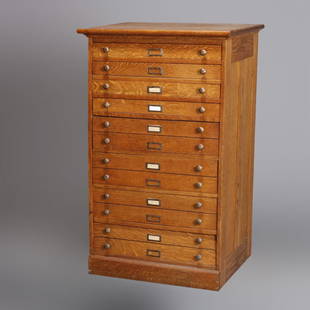
Sold2020Eight Drawer Oak Map, Art or Print File Cabinet, C 1910An antique map, art or print fining cabinet offers oak construction with eight drawers, brass pulls throughout, c1910. Measures- 45.5" H x 28" W x 22.75" D. ***IN-HOUSE SHIPPING & DELIVERY QUICK QUOTESee Sold Price
2 days LeftJasper521696 SYRIA Asia Minor & Syrian-Arabic region HISTORY antique ILLUSTRATED vellum$340
5 days LeftTrillium Antique Prints & Rare BooksDe Jode, Rare, pub. 1593 - Map of Asia (Tertiae Partis Asiae)$100
5 days LeftTrillium Antique Prints & Rare BooksHarris - Map of India and East Indies Islands (Part of China & East Asia)$75
5 days LeftTrillium Antique Prints & Rare BooksDavid Roberts - Statues of Memnon at Thebes, During the Inundation$200
5 days LeftTrillium Antique Prints & Rare BooksDavid Roberts, RSE - Pair of Lithographs of Scenes in Cairo$500
5 days LeftTrillium Antique Prints & Rare BooksDavid Roberts - Pair of Lithographs of Boats on the Water$200
5 days LeftTrillium Antique Prints & Rare BooksCaptain Cook - Hawaii: A View of Karakakooa, in Owyhee. 68$75
5 days LeftTrillium Antique Prints & Rare BooksCaptain Cook - Hawaii: A Man of the Sandwich Islands, in a Mask. 66$75
5 days LeftTrillium Antique Prints & Rare BooksCaptain Cook - Hawaii: A Canoe of the Sandwich Islands, the Rowers Masked. 65$75
5 days LeftTrillium Antique Prints & Rare BooksCaptain Cook - Tonga: The Reception of Captain Cook, in Hapaee. 14$75
5 days LeftTrillium Antique Prints & Rare BooksPrevost - Chart of the South Pacific Ocean with part of New Holland (Australia), New Zealand, and$75
5 days LeftTrillium Antique Prints & Rare BooksPrevost - 5 Botanical or Flora Engravings (Banana, Mango, Pineapple, Papaya, Coconut)$75