Sold2019ASSEMBLED LOT OF VINTAGE MAPSASSEMBLED LOT OF VINTAGE MAPS: Maps of the east coast, National Geographic maps, AAA road maps, 6 1/4" X 10 1/2" $40 - $80 Shipping:See Sold Price
Sold2022Vintage Map Print - Map of the World - Africa - Europe - Australia - 1972Title: Vintage Map Print - Map of the World - Africa - Europe - Australia - 1972 Description: A wonderful lithographic map from a magazine National Geographic. National Geographic has been publishingSee Sold Price
Sold2018Vintage Maps110+ Assorted California Maps; 50+ Assorted USA and World Maps; 25+ national Geographic Magazine Maps; 1950s -60s Classic Artistic. Road Maps of the Western States; 7Union Oil; Chevron Oil; Shell Oil;See Sold Price
Sold2019Vintage National Geographic Magazine's Map of Mexico,Description: Vintage paper map from National Geographic Magazine, depicting Mexico, Central America & the West Indies. Copyright 1939. Material: paper. Measurement: approximate 33"h x 40"w (INCHES). SSee Sold Price
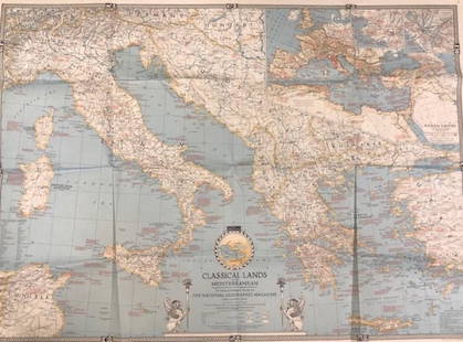
Sold2020Vintage National Geographic MagazineDescription: Vintage paper map from National Geographic Magazine, depicting the classical lands of the Mediterranean. Copyright 1940. Material: paper. Measurement: approximate 26.5"h x 34"w (INCHES).See Sold Price
Sold2022Vintage Map Print - Europe -The Historic Mediterranean - Italy - Greece - 1982Title: Vintage Map Print - Europe -The Historic Mediterranean - Italy - Greece - 1982 Description: A wonderful lithographic map from a magazine National Geographic. National Geographic has been publisSee Sold Price
Sold2022Vintage Discovery, Map, EphemeraThis lot consists of 1 postcard autographed by George Wallace, 4 invitation letters to the Space Shuttle Columbia liftoff in 1986, 1 $2 bill, various National Geographic maps (approx 30) and 3 AfricanSee Sold Price
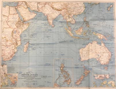
Sold2020Vintage National Geographic Magazine map of the IndianDescription: Vintage color paper map from National Geographic Magazine depicting the Indian Ocean. Copyright 1941. Material: paper. Measurement: approximate 26.5"h x 34"w (INCHES). Shipping cost: $12;See Sold Price
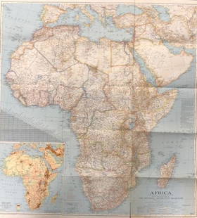
Sold2020Vintage National Geographic Map of AfricaDescription: Vintage color paper map from National Geographic Magazine depicts Africa. Some tearing on bottom. Map is copyrighted from 1943. Material: paper. Measurement: approximate 26.5"h x 34"w (INSee Sold Price
Sold2024Large Group of Vintage Magazines and MapsLarge Group of Vintage Magazines and MapsIncluding, Popular Mechanics, Army Talks, Flying Aces, Battle Maps, Popular Science, and maps from National Geographic Magazine.See Sold Price
Sold2017Collection of 35 vintage mapsCollection of 35 vintage maps mostly from The National Geographic Magazine including Northern Africa; The Philippines; The Top of the World; Scandinavia; Northern Europe; Southwestern United States; JSee Sold Price
Sold2020(44)Vintage National Geographic Maps - Asst Regions(44)Vintage National Geographic Maps - Asst RegionsSee Sold Price
Sold2020c 1920 s TRAVEL MAP ROUTES to YOSEMITE NATIONAL PARK byc 1920 s TRAVEL MAP ROUTES to YOSEMITE NATIONAL PARK by CALIFORNIA AUTO ASSOC. Vintage Circa 1920s Travel Map and Guide; "ROUTES to YOSEMITE NATIONAL PARK". Copyright by California State Automobile AsSee Sold Price
Sold2021Bartholomew, John 1904 Lot of 4 Railway Maps UK IrelandRailways of Scotland, Ireland, England & Wales, and General Map of the British Isles with Railway & Steamship Routes. Lithograph Map Published 1904, London for "The Survey Gazetteer of the British IslSee Sold Price
Sold2024Vintage 1937 British Isles map(29.5in.x36in.)Vintage 1937 British Isles map(29.5in.x36in.)See Sold Price
Sold2019British Isles C1870 Lot of 4 Maps by The NationalGeology/Physical Maps. Lithograph Map Published C1870 by the National Society for Promoting the Education of the Poor for "Maps illustrative of the physical, political, and historical geography of theSee Sold Price
Sold2022Ireland.- Ortelius (Abraham) Eryn. Hibernaie, Britannicae Insuale, engraved map, [c. 1590].NO RESERVE Ireland.- Ortelius (Abraham) Eryn. Hibernaie, Britannicae Insuale, the first map of Ireland to include any geographic details, based on Mercator's 1564 wall map of the British Isles and isSee Sold Price
Sold2021VARIOUS VINTAGE NEW YORK TRANSPORTATION GUIDESVARIOUS VINTAGE NEW YORK TRANSPORTATION GUIDESTravel around New York and surrounding areas by train, trolley, bus, and ferry with these fun vintage route maps and street guides!See Sold Price
Sold2022National Geographic Magazine Jan. to June 1927National Geographic Magazine January to June 1927 Bound in one volume. Map is present. Blue cloth with leather spine title bands. Included in this issue are: Jamaica,See Sold Price
Sold2022National Geographic Magazine Jan. to June 1927National Geographic Magazine January to June 1927 Bound in one volume. Map is present. Blue cloth with leather spine title bands. Included in this issue are: Jamaica,See Sold Price
Sold2024Stanford, Edward 1901 Large Map. Geological Map of the British IslesLarge Folio Lithograph Map Published 1901, London for "Stanford's London Atlas of Universal Geography" by Edward Stanford. Centre fold as published. Paper Size: 29 x 21.5 inch (74 x 55cm) Very minor tSee Sold Price
Sold2024Stanford, Edward 1901 Large Map. Stereographical Map of The British IslesLarge Folio Lithograph Map Published 1901, London for "Stanford's London Atlas of Universal Geography" by Edward Stanford. Centre fold as published. Paper Size: 29 x 21.5 inch (74 x 55cm) Left marginSee Sold Price
Sold2024Stanford, Edward 1901 Large Map. Hydrographical Map of the British IslesLarge Folio Lithograph Map Published 1901, London for "Stanford's London Atlas of Universal Geography" by Edward Stanford. Centre fold as published. Paper Size: 29 x 21.5 inch (74 x 55cm) Good ConditiSee Sold Price
Sold2024Stanford, Edward 1901 Large Map. British Isles - Railway MapLarge Folio Lithograph Map Published 1901, London for "Stanford's London Atlas of Universal Geography" by Edward Stanford. Centre fold as published. Paper Size: 29 x 21.5 inch (74 x 55cm) Very minor tSee Sold Price
3 days LeftPotter & Potter AuctionsCRISANTI, Mark (American, b. 1964) National Geographic # 4....$300
4 days LeftRail & Road Auctions45 Peices of Western Railroad Paper Ephemera - Southern Pacific, Northern Pacific, Union Pacific,$30(1 bid)
3 days LeftJasper52WEST INDIES Caribbean Windward Leeward Islands Barbados Pirates? MALLET 1683 map$240
1159 Lots AwayRapid Estate Liquidators and Auction GalleryMonmouth, Illinois Vintage Topography Map$30
2 days LeftFreeman's | Hindman[Maps & Atlases] A New Map of North America, with the West India Islands...$300
2 days LeftLunds Auctioneers & Appraisers Ltd.Book & Map: "Some Account of the British Dominions Beyond the Atlantic", 1776, William DCA$550(2 bids)
Freeman's | Hindman[MAPS - LOUISIANA - WAR OF 1812]. Maps of Louisiana, incl. Battle of New Orleans battle site map.$150(1 bid)
2 days LeftLiberty & 33rd Furniture Co.Antique Victorian Walnut Architect's Blueprint Flat File Cabinet or Collector's Cabinet$800
7 days LeftBrandywine Valley AuctionsVintage British School Artist Dion Pears Battle of Britain Oil Painting Signed$50(1 bid)


![Ireland.- Ortelius (Abraham) Eryn. Hibernaie, Britannicae Insuale, engraved map, [c. 1590].: NO RESERVE Ireland.- Ortelius (Abraham) Eryn. Hibernaie, Britannicae Insuale, the first map of Ireland to include any geographic details, based on Mercator's 1564 wall map of the British Isles and is](https://p1.liveauctioneers.com/5458/248003/128645375_1_x.jpg?height=310&quality=70&version=1652282230)


![[Maps & Atlases] A New Map of North America, with the West India Islands... (1 of 2)](https://p1.liveauctioneers.com/65/332523/179335173_1_x.jpg?height=282&quality=70&version=1717709447)


![[MAPS - LOUISIANA - WAR OF 1812]. Maps of Louisiana, incl. Battle of New Orleans battle site map. (1 of 7)](https://p1.liveauctioneers.com/197/333931/180433328_1_x.jpg?height=282&quality=70&version=1718838007)


