Sold20231815 Bowyer Map of Elba and Napoleon's Portrait -- Map of the Island of ElbaTitle: 1815 Bowyer Map of Elba and Napoleon's Portrait -- Map of the Island of Elba Cartographer: R Bowyer Year / Place: 1815, London Map Dimension (in.): 13.4 X 8.7 in. This is a magnificent presentaSee Sold Price
Sold2016Lot of two prints. 1) Porto Ferrajo and The Isle ofLot of two prints. 1) Porto Ferrajo and The Isle of Elba. Portrait of Napoleon with a View and Map of Elba. Published 1815. Engraved by Davies. 13-1/2" x 8-3/4". Overall size: 20-1/2" x 15-1/2". 2) TaSee Sold Price
Sold2019ELBA. Italian island.Title/Content of Map: ELBA. Italian island. Date: 1576-1590. Cartographer: By Porcacchi Size: 8x12”. Provenance: Republic of Venice First map of island published in atlas. Decorated with a mermaid,See Sold Price
Sold2020"Italy". Island of Elba. Kingdom of Naples, PapalTITLE/CONTENT OF MAP: 'Italy // Island of Elba' The map shows the Italian states largely as they had been prior to the French Revolution. Inset in the top right hand corner is a map of Elba, the islanSee Sold Price
Sold2018INVASION OF NAPLES 1806: Napoleonic Wars. Elba.TITLE/CONTENT OF MAP: 'Map of South Italy, to Illustrating the Invasion of Naples, &c., 1806; Inset map of the Island of Elba' DATE PRINTED: 1848 IMAGE SIZE: Approx 15.5 x 21.0cm, 6 x 8.25 inches (MedSee Sold Price
Sold2020Antique L. Salesio Napoleonic Figural LampDESCRIPTION:Antique Napoleonic Figural Lamp. Titled: EL L'ISLE D'ELBA, LA REVE'; "DREAMING OF ELBA ISLAND". Depicts a seated Napoleon looking at storming troops. SIgned " Salesio" Stamp on side of bacSee Sold Price
Sold20211865 Hawaiian Islands Pacific Islands Kamehameha1865 Hawaiian Islands Pacific Islands Kamehameha Portraits EARLY HAWAII MAP Rufus Anderson’s “The Hawaiian Islands” is a 19th-century account of the Pacific islands covering the origin of the isSee Sold Price
Sold2022Napoleon invades Russia, with 2 maps, 1815Heading: Author: Porter, Robert Ker Title: Narrative of the Campaign in Russia During the Year 1812... to which is added A Narrative of the Events Which Followed Buonaparte's Campaign in Russia to thSee Sold Price
Sold2015History of Battery E, 1st Regiment Rhode Island 1892Lewis, George. History of Battery E, 1st Regiment of Rhode Island Light Artillery. Providence: Snow and Farnham, 1892. Illustrated with portraits and map. 1st Edition.Inv. 1076See Sold Price
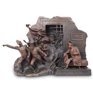
Sold2024A Patinated Metal Napoleonic Sculptural Lamp, after SalesioA Patinated Metal Napoleonic Sculptural Lamp, after SalesioLugli Salesio (Italian 1869-1936), a Napoleonic table lamp, the sculpture emblematic of Napoleon's exile on the island of Elba, dreaming of aSee Sold Price
Sold2019Central Europe.- Napoleon.- Bowyer (R., publisher) ANO RESERVE Central Europe.- Napoleon.- Bowyer (R., publisher) A Map Exhibiting the Retreat of the French Army from Moscow to Paris, in three horizontal sections, depicting the disastrous retreat of NaSee Sold Price
Sold20211855 Napoleon Bonaparte Exile on Elba Napoleonic Wars1855 Napoleon Bonaparte Exile on Elba Napoleonic Wars French Rev Island Empire Napoleon Bonaparte’s military leadership in the early 19th-century is considered some of the most impactful and inSee Sold Price
Sold2024NAPOLEONIC EUROPE. French Revolution 1793- Bonaparte's abdication 1815 1876 mapCAPTION PRINTED BELOW PICTURE: 'Europe from the Revolution (1793) to the abdication of Napoleon Bonaparte 1815' DATE PRINTED: 1876 IMAGE SIZE: Approx 15.5 x 22.5cm, 6 x 8.75 inches (Medium) TYPE: AntiSee Sold Price
Sold2020Antique Map (C18C.) Crete & Etching of M. Pepyn1. Map depicting Greek island of Crete and surrounding islands. 2. Martinus Pepyn portrait etching. Dimensions: 1.12.25" x 16.5 framed 18.5 x 22.5 2. 9 7/8 x 6.25 framed 18.75 x 14 7/8 (SHAA7510/2)(JPSee Sold Price
Sold2022(NAPOLEON.) Campagne des Francais en Italie, en 1800.(NAPOLEON.) Campagne des Francais en Italie, en 1800. Stipple engraved portrait of Napoleon, [iv], 34 pages, 4 engraved folding maps differently hand-colored to illustrate the French invasion of northSee Sold Price
Sold20172 FRAMED NAPOLEON ENGRAVINGSA pair of profesionally framed and matted antique Napoleon color engravings. The first is Napoleons Return from Elba, the other is a classic portrait. In matching frames, each measures 15.50"x12.50"x1See Sold Price
Sold2023The March of the Twenty-SixFirst edition. 'The Story of Napoleon's Marshals'. 1796-1815. Publishers navy cloth with gilt title to spine. Map endpapers. Full-page plates. Napoleon created 26 Marshals of France who held the higheSee Sold Price
Sold2021ST. LOUIS 1904 WORLD'S FAIR OFFICIAL SOUVENIR MUGST. LOUIS 1904 WORLD'S FAIR OFFICIAL SOUVENIR MUGMetal, enameled cup. Featuring the Eads Bridge, map of 1803 Louisiana Purchase, and portraits of Jefferson and Napoleon. 2.75" heightSee Sold Price
Sold2016[War, Military History, Lot of 3]Including: ***** 1: Hooper, George. WATERLOO: THE DOWNFALL OF THE FIRST NAPOLEON: A HISTORY OF THE CAMPAIGN OF 1815. London, 1862. 8vo. 1st ed. Maps and plates. Modern 1/4 calf, spine in gilt. Very GoSee Sold Price
Sold2016Napoleon's Pocket Map of Europe. 1811-12Carte des Routes des Postes de l'Empire Francais du Royaume de l'Italie et de la Confederation du Rhin. Tardieu, gravieur des postes Imperiales, 1812. Approximately 50 x 56 1/4 inches, color outlSee Sold Price
Sold2021Europe In Napoleon's Time 1897Title/Content of Map: Europe In Napoleon's Time 1897 Date Printed: 1897 Cartographer: I.S. Clare Material/Medium: Paper Size: approx. 11x14 inches Additional Info: Cram's Universal Atlas Reserve: $30.See Sold Price
Sold2017Allard Map of America with California as Island, 1697Map: Allard Map of America with California as Island - Recentissima Novi Orbis sive Americae Septentrionalis et Meridionalis Tabula Cartographer: C. Allard Date: ca. 1697 Size: 19 x 22.5 inches Nice lSee Sold Price
Sold2020New and Complete Map of Scotland, And Islands TheretoTitle/Content of Map: New and Complete Map of Scotland, And Islands Thereto Belonging; Cartographer: Date: 1779 Publisher: ROBT. SAYER Size: 46.7Height - 39.7Width "from actual surveys, the Shires proSee Sold Price
Sold2021FRENCH SCHOOL (19TH CENTURY).Oil on canvas. Portrait of Napoleon. From a Long Island, NY collection. - Dimensions: 9.5" high x 7.5" wideSee Sold Price
Jun 06Elmwood'sAN ANTIQUE CAROLINE MURAT, QUEEN OF NAPLES PORTRAIT MINIATURE set with a painted miniature portrait£1,800
Featured4 days LeftJasper521750 Bowen Map of Bermuda and St. Kitts -- A New & Accurate Map of Bermudas or Sommer's Islands...$600
Featured4 days LeftJasper521867 Beers Map of New York City Area -- Map of New York and Vicinity Accompanying "Atlas of New York$200
6 days LeftFreeman's | Hindman[CIVIL WAR]. Archive of items related to Elisha Hunt RHODES (1842-1917), 2nd Rhode Island Volunteer$750
Jun 07Freeman's | HindmanHARDY, Thomas. The Short Stories. 1928. WITH FORE-EDGE PAINTING of a portrait of Hardy.$150
Jun 06Freeman's | HindmanSTEVENSON, Robert Louis (1850-1894). Treasure Island. London, Paris & New York: Cassell & Company,$1,500
5 days LeftForum AuctionsStevenson (Robert Louis) Treasure Island, first edition, first issue, 1883.£1,000
Jun 08Early American History Auctionsc 1730 Hand-Colored Colonial Era Map of the Americas, California shown as an Island, Matted + Framed$500(1 bid)
Featured4 days LeftJasper521630 Mercator Map of Bermuda -- Mappa Aestivarum Insularum Alias Bermudas Dictarum ad Ostia Mexicane$320
Featured4 days LeftJasper52c1720 World showing Dutch East India Co possessions. CA as a island. By J.Malherbe$600
Jun 08Early American History Auctionsc 1797 JOHN ADAMS, President of the United States of America. Historical Liverpool Creamware Pitcher$2,000


![(NAPOLEON.) Campagne des Francais en Italie, en 1800.: (NAPOLEON.) Campagne des Francais en Italie, en 1800. Stipple engraved portrait of Napoleon, [iv], 34 pages, 4 engraved folding maps differently hand-colored to illustrate the French invasion of north](https://p1.liveauctioneers.com/199/251723/130782477_1_x.jpg?height=310&quality=70&version=1655133895)


![[War, Military History, Lot of 3]: Including: ***** 1: Hooper, George. WATERLOO: THE DOWNFALL OF THE FIRST NAPOLEON: A HISTORY OF THE CAMPAIGN OF 1815. London, 1862. 8vo. 1st ed. Maps and plates. Modern 1/4 calf, spine in gilt. Very Go](https://p1.liveauctioneers.com/3532/91776/46880618_1_x.jpg?height=310&quality=70&version=1469669287)


![[CIVIL WAR]. Archive of items related to Elisha Hunt RHODES (1842-1917), 2nd Rhode Island Volunteer (1 of 6)](https://p1.liveauctioneers.com/197/329785/177758366_1_x.jpg?height=282&quality=70&version=1715625218)


