Sold202118th C Large Handcolored Mercator Map GermanyLarge beautifully handcolored map of Braunswyck and Meydburg after Gerard Mercator circa 1640, this being an 18th century restike.. Printed at Amsterdam. Measures 23 x 19". Fine, reinforced central veSee Sold Price
Sold20241630 Mercator Map of Northern Germany -- Saxonia Inferior et Meklenborg Duc:Title: 1630 Mercator Map of Northern Germany -- Saxonia Inferior et Meklenborg Duc: Cartographer: G Mercator Year / Place: 1630, Amsterdam Map Dimension (in.): 7.2 X 9.8 in. This is an excellent map oSee Sold Price
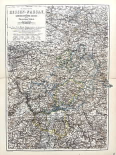
Sold2022Original Antique Map -Hessen Nassau - Map of Furstenthum WaldeckAntique outline hand colored map from edition of Meyer’s world atlas, edited by Ludwig Ravenstein, published by Bibliographic Institute in 1872. Technique: Engraving. Place: Leipzig, Germany. SSee Sold Price
Sold2024Gerhard Mercator Bolonia & Gvines ComitatusThis map shows the area around Duisburg, Germany, drawn around 1630. It stretches along the coast from Berck to Gravelines, including many details. You can see lots of rivers, forests, and villages, aSee Sold Price
2016Rugen / Germany 1611Map Title: Nova Famigerabilis Insulae Ac Ducatus Rugiae Descriptio..(Rich in Heraldry Rugen/ Germany) Published: Mercator-Hondius, Amsterdam Date: 1611 Size: 14.75 x 19 inches. Highly decorative map oSee Sold Price
Sold2022Ancient map of a region of Bavaria, 1628Authentic vintage map of the Rhineland Palatinate of Bavaria in Southern Germany. From an edition of Mercator’s Atlas Minor. Jocodus Hondius created the Atlas Minor in 1607 as a smaller versionSee Sold Price
Sold2017Mercator (Gerard) - Atlas sive Cosmographicae,Editio Quinta, engraved pictorial title, prelims, 49 double-page maps, including Asia, Russia, Turkey, Lithuania, Asia Minor and Persia, regions of Italy Spain, Germany and Eastern Europe, and 11 singSee Sold Price
Sold20181695 Mercator Map of the Known World -- UniversalisTitle/Content of Map: 1695 Mercator Map of the Known World -- Universalis Tabula Iuxta Ptolemaeum Date: 1695, Amsterdam Cartographer: G Mercator Size: 13.7 x 18.6 in. This outstanding and decorative mSee Sold Price
Sold2018Mercator map of the North Pole 1619Heading: Author: Mercator, Gerard Title: Septentrionalium Terrarum descriptio Place Published: Amsterdam Publisher: Date Published: 1595-[1619] Description: Copper-engravedSee Sold Price
Sold2020Mercator's map of Americas in 1595Heading: Author: Mercator, Michael Title: America siue India Nova ad Magnæ Gerardi Mercatoris aui Universalis imitationem in compendi um redacta. Per Michaelem Mercatorem Duysburgensem Place PublishSee Sold Price
Sold2020Mercator map of AsiaGerardus Mercator (1512-1594), ''Asia ex magna orbis terre descriptione Gerardi Mercatoris desumpta studio et industria G.M. Iunioris,'' Amsterdam, ca. 1613. map of Asia with hand-coloring, from MercaSee Sold Price
Sold2020Gerardus Mercator Map of Asia 1613Gerardus Mercator (1512-1594), "Asia ex magna orbis terre descriptione Gerardi Mercatoris desumpta studio et industria G.M. Iunioris," Amsterdam, ca. 1613. Hand colored map of Asia. Dimensions: Sight;See Sold Price
Sold2019Mercator's map of Americas in 1595Heading: Author: Mercator, Michael Title: America siue India Nova ad Magnæ Gerardi Mercatoris aui Universalis imitationem in compendi um redacta. Per Michaelem Mercatorem Duysburgensem Place PublishSee Sold Price
Sold201916th century Natolie Sive Asie Minor Mercator Map16th Century fine early map of Turkey in Asia, published in Amsterdam by Gerard Mercator. Strapwork cartouche at lower right. Two more cartouches, one shows scales, the other has a Latin inscription.See Sold Price
2017Hondius / Mercator: Map of Japan & Korea, 1630Map: 1630 Hondius / Mercator Map of Japan and Korea - Iaponia Cartographer: J. Hondius / G. Mercator Year / Place: 1630 c. Amstredam Map Dimensions: 13.4 x 17.4 in. Condition: Excellent - very good coSee Sold Price
Sold2017Mercator: Map of Japan with Korea, 1630Title: Iaponia Map maker: Gerard Mercator & J.E. Cloppenburgh, Pieter Van Den Keere Place and Year: Amsterdam, 1630 Dimensions: 18.8 x 24.6 cm (7.4 x 9.7 in) Technique: Copperplate engraving Coloring:See Sold Price
Sold20241630 Mercator Map of Asia -- AsiaTitle: 1630 Mercator Map of Asia -- Asia Cartographer: G Mercator Year / Place: 1630, Amsterdam Map Dimension (in.): 7.3 X 10 in. This is an excellent smaller map of Asia. This map still show many mytSee Sold Price
Sold2019Mercator, map of Morea, Greece, 1630Mercator, map of Morea, Greece, 1630, Gerard Mercator, "Morea olim Peloponnesus", Peloponnese Peninsula, Greece, hand-colored copper engraving, published as part of an atlas by J. Hondius, Jr., AmsterSee Sold Price
Sold2017Mercator: Map of South East England, 16131613 Mercator Map of South East England -- Warwicum, Northhamtonia, Huntingdonia, Cantabrigia, Suffolcia, Oxonium, Buckinghamia, Bedfordia, Hartfordia, Effexia. Mercator's great map of the southeast rSee Sold Price
Sold2023MAP, Germany, Braun & HogenbergMainz & Wurzburg, Germany & Sion, Switzerland. Braun & Hogenberg, Moguntia, Germaniae Metropolis, ad Rheni... [on sheet with] Herbipolis, Comuniter Wirtzburg... [and] Sedunum, Primaria & MetropoliticaSee Sold Price
Sold20221630 Mercator Map of Catalonia of Spain -- CataloniaTitle: 1630 Mercator Map of Catalonia of Spain -- Catalonia Cartographer: G Mercator Date/Place: 1630, Amsterdam Dimensions: 7.2 X 9.9 in. Description: This is an attractive map showing the province oSee Sold Price
Sold2016Mercator map of RussiaHeading: Author: Mercator, Gerard / Jodocus Hondius Title: Russia cum Confinijs Place Published: Amsterdam Publisher: Date Published: 1609-[1628-33] Description: Copper-engSee Sold Price
Sold2022FRAMED HANDCOLORED MERCATOR MAP OF THE WORLD BY JOHNSON & WARD, 1863From Johson's "Family Atlas" of 1863, Western & Eastern Hemisphere, joined sheets, as issued, in gilt molded panel frame, black mat with gilt liner, under glass, OS: 23 1/4" x 34 1/4", SS: 16" x 27",See Sold Price
Sold20241630 Natolie Sive Asia Minor Mercator Mapearly map of Turkey in Asia, published in Amsterdam by Gerard MercatorSee Sold Price
4 days LeftJasper52Large Antique French map GERMAN EMPIRE 1792 colored by POIRSON engraver Basset$170
4 days LeftJasper52Rand, McNally & Co.'S Indexed Atlas of the World Map of Germany (Western Sheet). | (Eastern Sheet).$60
4 days LeftJasper521799 Cary Map of Germany's Franconia -- A New Map of the Circle of Franconia, from the Latest$70
4 days LeftJasper521801 Cary Map of Germany's lower Saxony -- A New Map of the Circle of Lower Saxony From the Latest$70
4 days LeftJasper521799 Cary Map of Germany's Bavaria -- A New Map of the Circle of Bavaria, from the Latest$70
5 days LeftJasper52Atlanta Karte der Besatzungs-Zonen. Map of the Occupation Areas of Germany 1946$440
11 hrs LeftTrillium Antique Prints & Rare BooksHomann - 3 Maps of Czech Republic, Austria, Russia$100
4 days LeftC & T Auctioneers and Valuers LtdTwo Vintage Action Force Red Shadows Black Major Variant Action Figures Series 2 carded moc 1983£80
Sep 28Trillium Antique Prints & Rare BooksHomann - 6 Maps of European Countries: France, Belgium, Denmark, Spain, Portugal$100


![Mercator map of the North Pole 1619: Heading: Author: Mercator, Gerard Title: Septentrionalium Terrarum descriptio Place Published: Amsterdam Publisher: Date Published: 1595-[1619] Description: Copper-engraved](https://p1.liveauctioneers.com/642/122092/62169135_1_x.jpg?height=310&quality=70&version=1526256630)


![MAP, Germany, Braun & Hogenberg: Mainz & Wurzburg, Germany & Sion, Switzerland. Braun & Hogenberg, Moguntia, Germaniae Metropolis, ad Rheni... [on sheet with] Herbipolis, Comuniter Wirtzburg... [and] Sedunum, Primaria & Metropolitica](https://p1.liveauctioneers.com/6576/279721/147265449_1_x.jpg?height=310&quality=70&version=1677104593)

![Mercator map of Russia: Heading: Author: Mercator, Gerard / Jodocus Hondius Title: Russia cum Confinijs Place Published: Amsterdam Publisher: Date Published: 1609-[1628-33] Description: Copper-eng](https://p1.liveauctioneers.com/642/93238/47584241_1_x.jpg?height=310&quality=70&version=1472923400)


